[https://books.google.com/books?id=fXNrb_v9q7MC&newbks=0&printsec=frontcover&source=gbs_ge_summary_r&cad=0#v=onepage&q&f=true](https://books.google.com/books?id=fXNrb_v9q7MC&newbks=0&printsec=frontcover&source=gbs_ge_summary_r&cad=0#v=onepage&q&f=true)
[https://mavink.com/post/80E9EAE75200E3B25ECF63A7A74B5E4242AM6D574F/sky-star-chart-constellations-map](https://mavink.com/post/80E9EAE75200E3B25ECF63A7A74B5E4242AM6D574F/sky-star-chart-constellations-map)
The attached document offers an extensive critique of traditional map projections, particularly focusing on the Mercator projection and its implications on our understanding of geography. The Mercator projection, developed by Gerardus Mercator in 1569, was revolutionary for navigation because it straightened lines of latitude and longitude, making it easier for sailors to plot courses using a compass. However, this projection significantly distorts landmasses, especially near the poles, leading to misconceptions about the relative size and importance of different regions, a phenomenon often referred to as the "Greenland problem."
The document challenges the conventional notion that maps simply project the globe onto a flat surface. Instead, it argues that maps project coordinate systems, most commonly the geographic coordinate system known as the Graticule, which is derived from celestial observations. This system is inherently spherical because it is based on angles to the stars, which are used to determine longitude and latitude. The document suggests that this reliance on celestial observations has led to the pseudoscientific notion of a globe Earth.
Furthermore, the document explores various types of map projections, such as cylindrical, conical, and azimuthal, each with its own set of distortions and uses. It highlights the azimuthal projection as unique, noting that it is often misrepresented in online discussions. The document emphasizes that all map projections are essentially different ways of representing the same coordinate system, which is inherently spherical due to its celestial origins.
Touching on the historical context of mapmaking, referencing the Longitude Act and the role of the Royal Society in establishing the prime meridian at Greenwich. It critiques the historical narrative that suggests longitude was a difficult problem to solve before the invention of the chronometer, arguing that celestial navigation methods were already highly effective.
In summary, the perception of a globe Earth is a result of projecting a spherical coordinate system derived from celestial observations onto maps. It calls for a reevaluation of how we interpret these projections and suggests that the true basis for understanding geography lies in the Graticule and celestial sphere, rather than the globe itself.
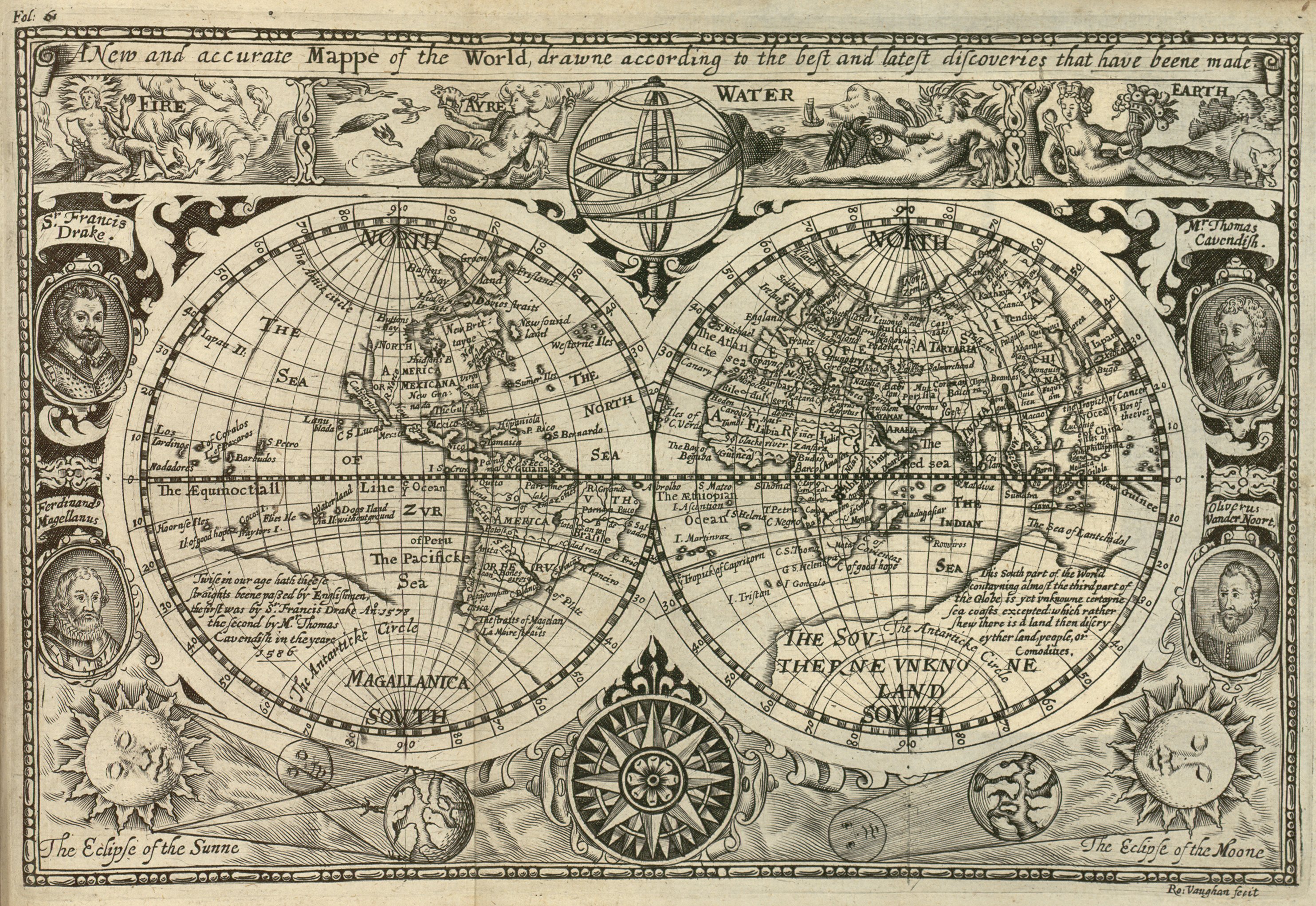
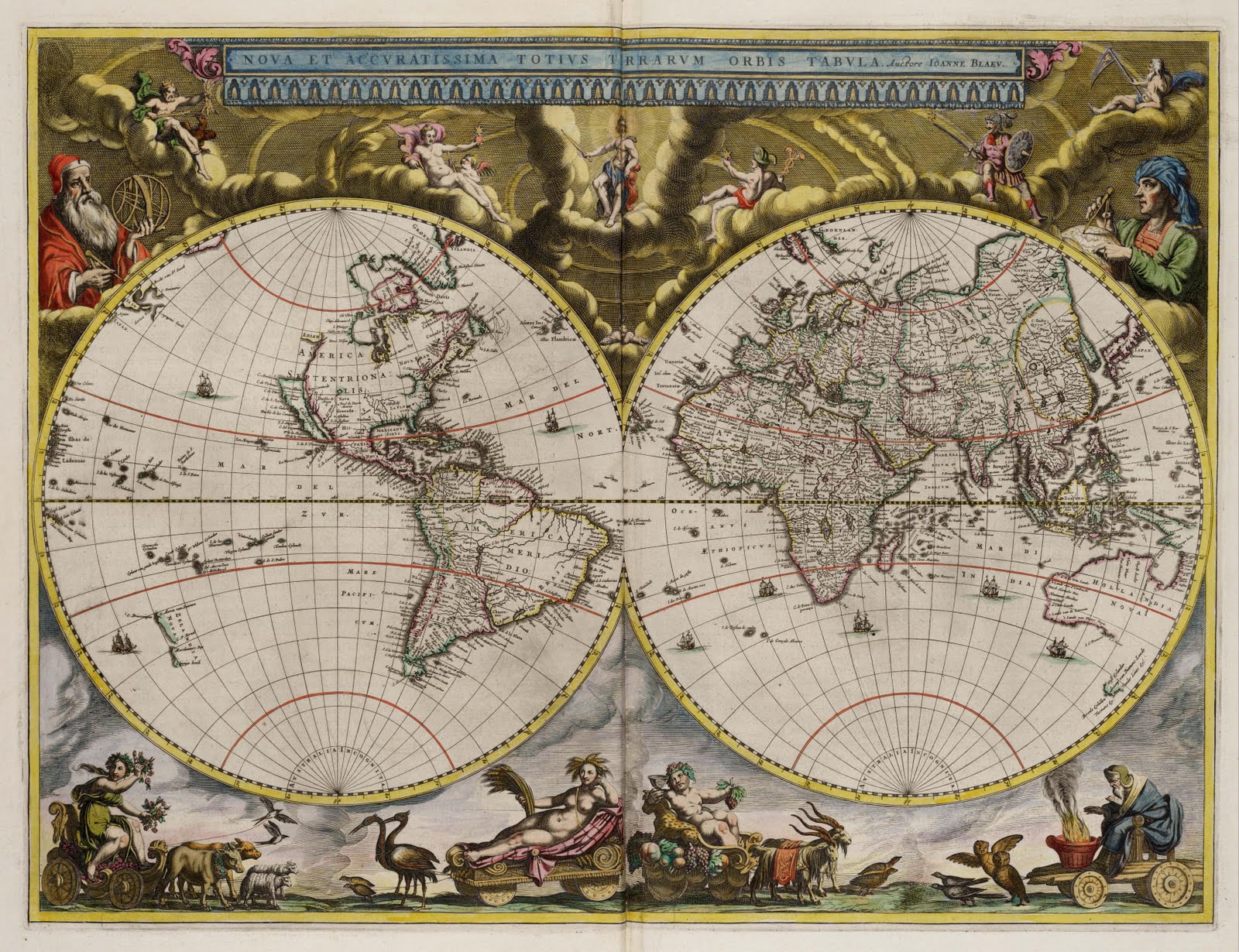
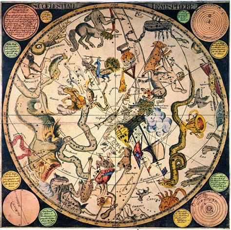
The place of humanity as the connecting centre of the cosmographic map made cosmography doubly geocentric. Methodologically, cosmography’s basic mapping procedure assumes a central earthly sphere around which the planets revolve. This remains true whether or not geocentricity is accepted as a scientific truth. E
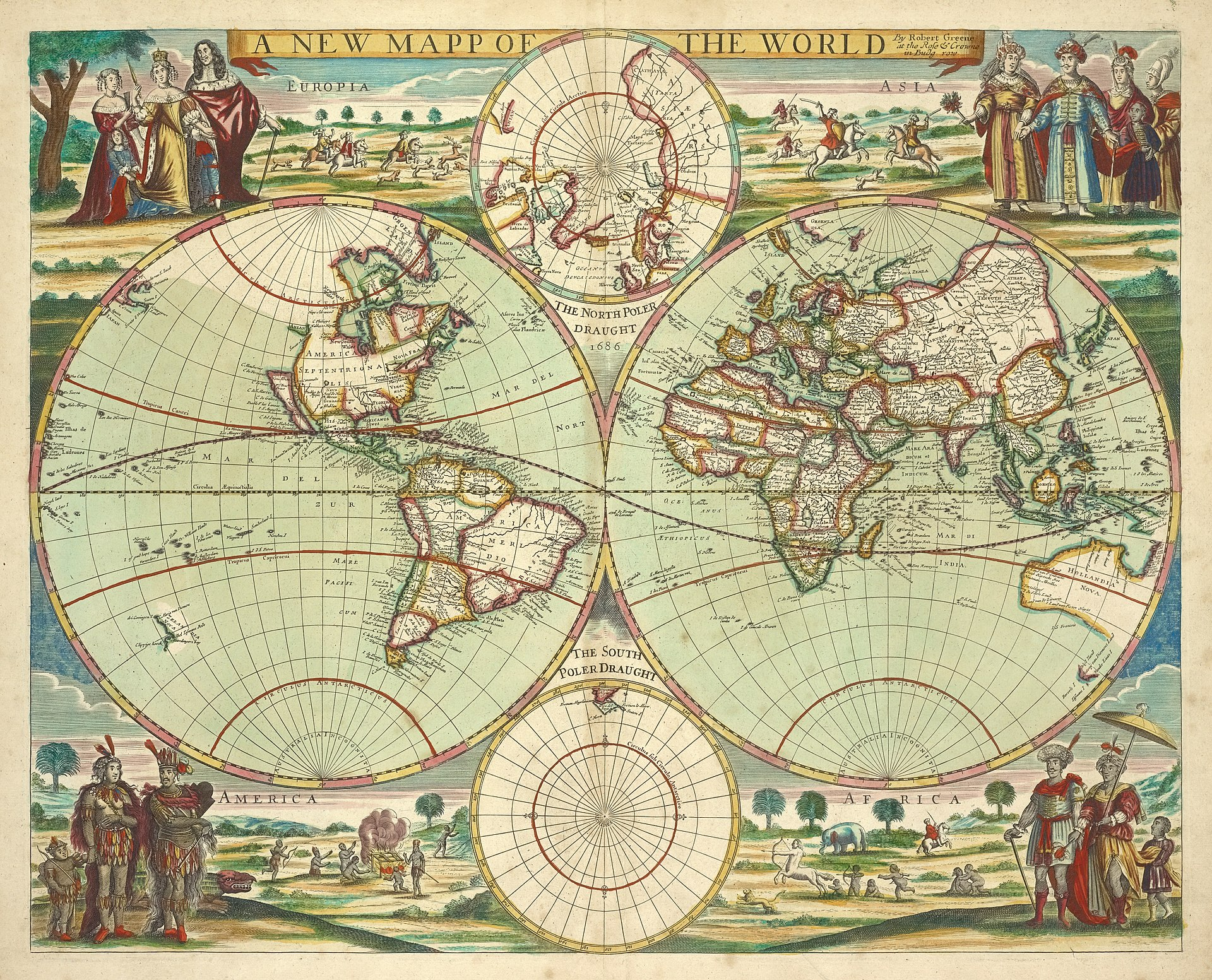
Cosmography and geography in two parts,
_Lawrence H. Slaughter Collection of English maps, charts, globes, books and atlases_
[https://digitalcollections.nypl.org/collections/atlases-gazetteers-guidebooks-and-other-books#/?tab=navigation&roots=79ca8ed0-683a-0132-072e-58d385a7b928](https://digitalcollections.nypl.org/collections/atlases-gazetteers-guidebooks-and-other-books#/?tab=navigation&roots=79ca8ed0-683a-0132-072e-58d385a7b928)
[https://digitalcollections.nypl.org/items/510d47da-ef57-a3d9-e040-e00a18064a99/book?parent=6a373d50-c5d3-012f-a6fb-58d385a7bc34#page/93/mode/2up](https://digitalcollections.nypl.org/items/510d47da-ef57-a3d9-e040-e00a18064a99/book?parent=6a373d50-c5d3-012f-a6fb-58d385a7bc34#page/93/mode/2up)
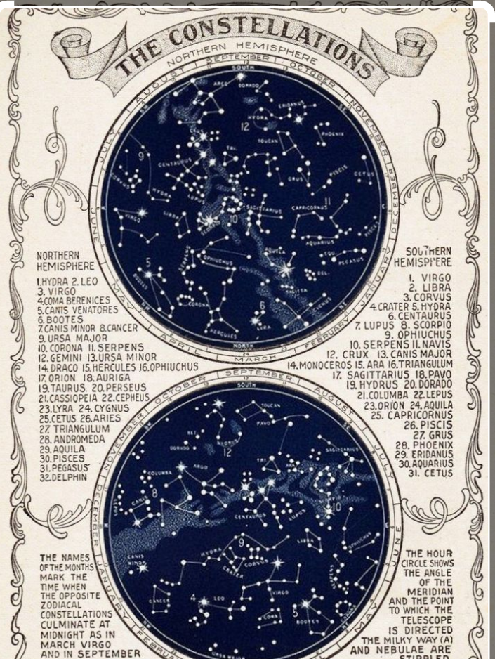
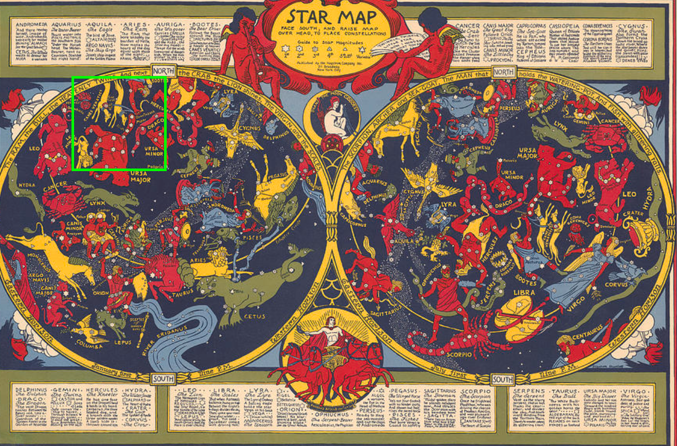
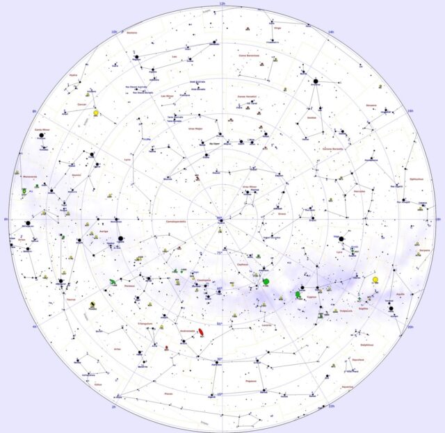
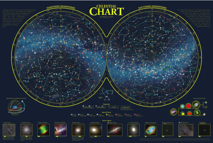
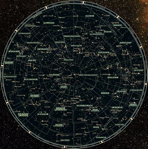
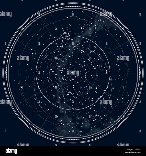
# Constellation Map
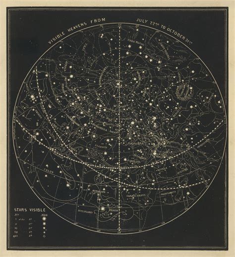
Constellation maps divide the celestial sphere into 88 parts, known as [constellations](https://www.constellation-guide.com/constellations/), helping astronomers locate stars and deep sky objects. The star constellations that can be seen in the night sky depend on the observer’s location and season, and they change throughout the year.
Out of the [88 constellations](https://www.constellation-guide.com/constellation-list/) recognized by the International Astronomical Union (IAU), 36 are found predominantly in the [northern sky](https://www.constellation-guide.com/constellation-map/northern-constellations/), while the remaining 52 are located in the [southern sky](https://www.constellation-guide.com/constellation-map/southern-constellations/).
As our planet spins on its axis, we see different constellations, with stars appearing to move across the sky from east to west, just as the Sun rises in the east and sets in the west from our point of view. As the Earth orbits around the Sun, constellations move slowly to the west over the course of a year and we see different parts of the sky at night because, as the seasons change, we are looking in a different direction in space. This means that different constellations are viewable at different times of year.
[](https://www.constellation-guide.com/wp-content/uploads/2021/06/northern-constellations.jpg)
Northern hemisphere map, image: Roberto Mura
The celestial sphere, an imaginary sphere surrounding Earth, is divided into the northern and southern hemispheres by the line of the Earth’s equator, extended into space. Similarly, the Earth’s North and South Poles, extended into space, mark the north and south celestial poles. The north celestial pole can be easily located because it is marked by [Polaris](https://www.star-facts.com/polaris/), a relatively bright star located in [Ursa Minor constellation](https://www.constellation-guide.com/constellation-list/ursa-minor-constellation/). The south celestial pole is a bit trickier to pinpoint because there are stars visible to the unaided eye marking its location.
[Polaris](https://www.star-facts.com/polaris/) and other stars lying near the celestial poles appear to move across a smaller area than stars lying closer to the equator. The farther they are from the poles, the wider the circle the stars make across the night sky. The stars that are close to the poles never set below the horizon for observers in locations where the stars are visible: they are circumpolar. Near the equator, there are no circumpolar stars. With the celestial poles on the horizon, all stars appear to rise in the east and set in the west for observers at the equator.
[](https://www.constellation-guide.com/wp-content/uploads/2021/06/southern-constellations.jpg)
Southern hemisphere sky map, image: Roberto Mura
Observers can never see [all 88 constellations](https://www.constellation-guide.com/constellation-list/) from a single location on Earth. While some of the [southern constellations](https://www.constellation-guide.com/constellation-map/southern-constellations/) can be seen from northern latitudes at certain times of year – [Scorpius](https://www.constellation-guide.com/constellation-list/scorpius-constellation/), for instance, is visible over the southern horizon in the summer – others never rise over the horizon. [Crux](https://www.constellation-guide.com/constellation-list/crux-constellation/), also known as the [Southern Cross](https://www.constellation-guide.com/the-southern-cross/), which is prominent enough in the southern sky to be featured on several national flags in the southern hemisphere, can never be seen from most locations north of the equator. Similarly, the constellation [Ursa Minor](https://www.constellation-guide.com/constellation-list/ursa-minor-constellation/), which contains [Polaris](https://www.star-facts.com/polaris/), the closest bright star to the north celestial pole, cannot be seen from most places south of the equator.
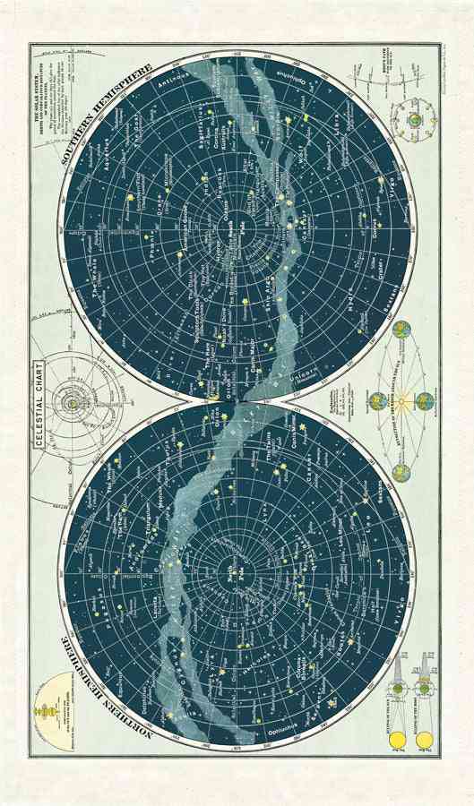
The position of all stars and deep sky objects on the celestial sphere is mapped relative to the celestial equator and poles, just as different locations on Earth are mapped using the equator and Greenwich, England. A star’s latitude or position north or south of the celestial equator is called declination, while its longitude or position east or west is called right ascension and measured in hours, minutes, and seconds.
## Links
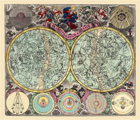
A New atlas of the mundane system; or, of geography and cosmography: describing the heavens and the earth, the distances, motions and magnitudes of the celestial bodies
Extracted from Samuel Dunn's "A New atlas of the mundane system; or, of geography and cosmography: describing the heavens and the earth, the distances, motions and magnitudes of the celestial bodies" (3rd or 4th ed.), London, Laurie & Whittle (1786-1789 or 1796).
[https://www.geographicus.com/P/AntiqueMap/america-dezauche-1800](https://www.geographicus.com/P/AntiqueMap/america-dezauche-1800)
[https://www.loc.gov/resource/g3200m.gct00242/?sp=1&st=slideshow](https://www.loc.gov/resource/g3200m.gct00242/?sp=1&st=slideshow)
Dezauche, Jean-Claude, Geographical atlas of the four parts of the world, (Dezauche: Paris), 1800.
[https://www.wired.com/2014/11/get-to-know-a-projection-azimuthal-orthographic/](https://www.wired.com/2014/11/get-to-know-a-projection-azimuthal-orthographic/)
The second, called the azimuthal stereographic, also looks at the planet, but from an eye placed on the far side of the globe _looking through it_. Where the orthographic causes the continents to fall away, and the gnomonic stretches them into infinity, the stereographic moderately stretches them towards the edges. Their sizes are slightly off, but their shapes and arrangement stay true to life. As such, it's the most practical of the three, and is useful for teaching geography or plotting sea voyages. Not only does it make a pretty classy looking world map, Hipparchus also used it to map the stars.

[http://www.berksastronomy.org/starcharts.htm](http://www.berksastronomy.org/starcharts.htm)
Celestial Cartography – Maps of the Heavens
With the invention of printing in the 15th Century, it was only a matter of time until maps and globes became commonplace. Printed maps of the world were soon supplemented with maps of countries and of towns. These were then assembled into terrestrial atlases.
Old maps are valued today not just for their beauty, but because they show how our knowledge of geography advanced over the centuries. Cities grew and the boundaries between countries changed over time. And the art of mapmaking itself evolved over time. The quality and accuracy of terrestrial maps make for a fascinating study of man’s quest for knowledge of the world.
Maps of the heavens followed a similar journey. Man’s knowledge of the heavens and the accuracy of celestial maps and atlases have marched hand in hand over the centuries. Charts of the sky were followed with charts of the constellations which were then collected into celestial atlases. The charts and atlases on display here chronicle this journey. Along with advances in scientific knowledge, celestial maps represent some of the most beautiful and artistic creations in the history of map making.


does the nautical mire deal with the circumference of a circle only
1. The video covers the most commonly employed celestial coordinate systems used to locate and track celestial objects, including the horizontal system and the equatorial system.
2. The horizontal system is based on the observer's local horizon, while the equatorial system is measured relative to the projection of the [celestial equator](https://en.wikipedia.org/?curid=153681).
3. The two coordinates in each system are similar - [altitude](https://en.wikipedia.org/?curid=59211)/[azimuth](https://en.wikipedia.org/?curid=47487) in the horizontal system and [declination](https://en.wikipedia.org/?curid=8612)/[right ascension](https://en.wikipedia.org/?curid=26073) or [local hour angle](https://en.wikipedia.org/?curid=48838) in the equatorial system.
4. The equatorial system is analogous to the [geographic coordinate system](https://en.wikipedia.org/?curid=48361), with the [celestial equator](https://en.wikipedia.org/?curid=153681) and [poles](https://en.wikipedia.org/?curid=49752) corresponding to the terrestrial equator and [poles](https://en.wikipedia.org/?curid=49752).
5. The projection of the equatorial system depends on the observer's [latitude](https://en.wikipedia.org/?curid=17616), with the [celestial equator](https://en.wikipedia.org/?curid=153681) tilting relative to the horizon.
6. Right ascension measures the angular or [sidereal time](https://en.wikipedia.org/?curid=48837) offset relative to the vernal equinox, while [local hour angle](https://en.wikipedia.org/?curid=48838) measures the angular offset from the local meridian.
7. Sidereal time, the Julian day system, [precession](https://en.wikipedia.org/?curid=24714), and [nutation](https://en.wikipedia.org/?curid=22094) are important concepts related to the equatorial coordinate system.
8. Precession causes the celestial [poles](https://en.wikipedia.org/?curid=49752) to trace a circular path due to the Earth's axis wobble, while [nutation](https://en.wikipedia.org/?curid=22094) creates smaller oscillations in the axis.
9. The video covers how to calculate Greenwich Apparent Sidereal Time ([GAST](https://en.wikipedia.org/?curid=37958996)) using the Julian date and the [equation of the equinoxes](https://en.wikipedia.org/?curid=438948).
**A Brief History of Printed Star Atlases**
**16th Century: Rough Beginnings, Ancient Origins**
The earliest printed depictions of the constellations were not true maps of the sky. Constellation figures were produced as woodcut diagrams with stars positioned to adorn the figures, but these star were not positioned to accurately portray the heavens.
It was not until 1515 that the first printed maps of the heavens appeared that accurately portrayed the night sky. In that year, the celebrated artist Albrecht Dürer produced a pair of woodcut northern and southern planispheres (hemispherical views of half the heavens). His planispheres included a coordinate system and attempted to accurately position the stars of the 48 constellations based on the star catalog contained in Ptolemy’s 2nd century _Almagest_. The _Almagest_ had been passed down through the centuries and was revered as the authoritative source for celestial information. While the _Almagest_ contained no celestial maps, it did contain a description of each of the ancient constellations based on the positions and brightness of the stars within each constellation.
Early planispheres and celestial globes were popular, and it was only a matter of time until a true celestial atlas was to appear on the cartographic scene.
The year was 1540, and the place was Venice. Italian cardinal Alessandro Piccolomini was a prolific writer who turned his attention to the production of a book about the constellations and their mythical lore. He included woodcut maps of all but one of Ptolemy’s constellations – the stars of the constellation Equuleus were too faint to be represented. On his maps Piccolomini indicated stellar magnitudes and a scale for each constellation. However, he chose to omit drawings of the constellation figures themselves. In addition, his star charts lacked any coordinate system so there was no way to accurately determine the positions of stars in the sky.
The first celestial atlas with an accurate coordinate system and constellation figures did not appear until 1588. In that year, Giovanni Gallucci published an atlas of 48 woodcut constellation charts. In addition, his atlas included nebulae – a generic term for faint milky or cloudy objects in the sky. Ptolemy had identified seven such objects in the _Almagest_, and Gallucci included all of these.
Nebulae first appeared on planispheres about 1540. It was about that time, too, that certain new or modern constellations began to appear. Once the ancient constellations were placed on a celestial map or globe, vacant areas became evident. Map and globe makers began to invent new constellations to add to these vacant areas.
Gallucci’s atlas was a major advance, but it was to be overshadowed in 1603 by the first of the great celestial atlases.
|||||
|---|---|---|---|
|||||
||**_Imagines Constellationum Borealium <br>_** – Basel, 1541-||**_Imagines Constellationum Australium_** <br>– Basel, 1541-|
Northern and Southern Woodcut Celestial Planispheres
Johannes Honter (1498-1549)
These early planispheres are typical of the first accurate celestial maps. They are divided at the ecliptic – the path that the sun and planets follow through the sky. The ecliptic is also the home of the zodiac. The twelve constellations of the zodiac lie along the ecliptic and the position of the sun within a constellation is the origin of the signs of astrology. The constellations of the zodiac appear along the edge of both maps.
The constellations on these planispheres are drawn from a geocentric viewpoint – in other words, the stars appear in the sky as they do when we look up at the heavens. Many early charts and atlases were drawn with an “external” or reverse-geocentric view like celestial globes. When we look “down” at the surface of a celestial globe, star patterns appear reversed because we are viewing them from outside the celestial sphere.
The primary coordinate system on these charts is ecliptical, but a secondary, equatorial coordinate system is also shown for the first time on these charts. The equatorial coordinate system (based on the equator of the Earth) would gain favor in the 18th century due to it’s superiority for determining positions in the sky. Today, equatorial coordinates are used almost exclusively.
No nebulae or modern constellations appear on these charts. Note that there are large, vacant areas in both the north and the south. The entire area around the south equatorial pole is vacant of constellations because this area was not visible from the Mediterranean or Middle East – the area where the ancient astronomers who invented the constellations documented in Ptolemy’s _Almagest_ lived.
These particular charts were printed from woodcuts that were probably made about 1532. Printed charts from these woodcuts first appeared in a book published in 1541, but these particular examples are probably from one of the many reprints of this book that were published over the next 30 to 40 years.

**_De Le Stelle Fisse_** – Venice, 1548
# Includes Atlas of 47 Woodcut Celestial Charts
Alessandro Piccolomini (1508-1579)
The first true star atlas was published in Venice in 1540 as part of a volume on the myths of the constellations. The atlas consisted of individual charts of 47 of the 48 Ptolemaic constellations. Stars were displayed geocentrically (as seen from the Earth) with four magnitudes. One constellation was omitted – Equuleus contains no bright stars, so its chart would have been blank!
The author, Alessandro Piccolomini, was a prolific writer with works on many subjects, but he is best known for his star atlas which he wrote while a student at Padua.
Piccolomini opted to just show star patterns in his atlas. Constellation figures were not drawn on the maps. In addition, his star charts lacked any coordinate system so there was no way to accurately determine the positions of stars in the sky or even the orientation of each constellation with regard to its neighbors. Each chart simply showed the direction to the equatorial pole and a scale in degrees which differed for each chart. No nebulae or modern constellations were included.
This atlas proved to be immensely popular. The original was published in Italian, but at least ten Italian, three French and three Latin editions are known with the final edition appearing in 1595. The original charts were woodcuts and these were used for the first three editions, but other publishers did not have access to the original woodcuts. Two later editions used typeset star charts, but the rest of the later editions used new woodcuts which were not as accurate as the originals.
The atlas on display is a second edition published in 1548. It is opened to the constellations Cetus and Orion.

**_Theatrum Mundi, et Temporis_** – Venice, 1588
# Includes Atlas of 48 Woodcut Celestial Charts
Giovanni Paolo Gallucci (1538-1621)
Giovanni Gallucci’s _Theatrum Mundi, et Temporis_ is an encyclopedic work covering the motions of the planets, the nature of eclipses, and calculations of precession – the path that the Earth’s poles trace through the sky over a period of 26,000 years as the Earth’s axis wobbles like a top.
_Theatrum Mundi_ also contains the first star atlas with an accurate coordinate system. Gallucci provides tables of star positions to magnitude 6 based on ecliptical coordinates derived from the star catalog published by Nicholai Copernicus in 1543. The atlas contains a woodcut star chart for each of the 48 Ptolemaic constellations, along with a table of star positions for each constellation given in degrees of latitude and longitude along with the magnitude of each star. The view is “external” or reverse-geocentric – the stars are shown reversed from how they actually appear in the sky.
Gallucci included drawings of the constellation figures, a trend that predominated well into the 19th century. In addition, his atlas included nebulae – a generic term for faint, cloudy objects in the sky. Ptolemy had identified seven such objects in the _Almagest_, and Gallucci included all of these. Few nebulae would appear in star atlases until late in the 18th century.
We know today that the nebulae depicted in early atlases represented a variety of objects ranging from clouds of interstellar gas to clusters of faint stars and even to galaxies far beyond the Milky Way. Unfortunately, the telescope was not invented until about 1607, and several of Ptolemy’s nebulae were nothing more than chance alignments of faint stars that appeared cloudy to the naked eye. Some nebulae on early atlases even appear to be imaginary – no objects can be found at these positions today. These “false” nebulae were sometimes perpetuated from atlas to atlas as each author copied his predecessors.
Gallucci included the first new constellation in his atlas but didn’t give it a chart of its own. Antinous, which had been introduced by the globe maker Casper Vopel in 1536, appears below the figure Aquila. Many new constellations would be introduced over the next two and a half centuries, and many of these remain in use today, but although Antinous was the first new constellation and was popular into the 20th century, it is no longer a recognized constellation.
The atlas on display is a first edition of 1588. It is opened to the constellation Cancer. A nebula symbol can be seen on Cancer’s back. This is actually a “false” nebula representing a faint group of several stars.
**17th Century: Art and Science on the Rise**
Cartography made a huge leap toward the end of the 16th century with the advent of copper engraved plates for printing illustrations. Copper engravings provided several advantages over woodcuts. The artist could produce much finer details engraving copper and the plates were more durable than woodcuts. The result was a stunning improvement in the overall quality of maps, both terrestrial and celestial.
But cartographic improvements were not the only advances that affected celestial atlases. Newer and more accurate star catalogs became available, and with the invention of the telescope in 1607, astronomers had a new tool with which to explore the heavens. In addition, catalogs of stars in the southern skies not visible in the north began to be available. The results were revolutionary.
The 17th century would lead off with the first of the four great star atlases in 1603 and would close with the second in 1690. In between, there would be many advances in science and many discoveries based on telescopic observations by astronomers of the day.
The first of what are recognized as the four great star atlases was published by Johann Bayer in 1603. _Uranometria_ was based on observations by Tycho Brahe whose star catalog began to circulate at the end of the 16th century. In Bayer’s _Uranometria_, the charts were larger, the constellation figures (still one to a page) were far more artistic, the stars were far more accurately placed and the grades of star brightness were more uniformly shown.
_Uranometria_ was the model for atlases of the 17th century. The overall format and content of atlases would not significantly advance until the 18th century.
Great artistic astronomical works also began to appear. These often included planispheres of the heavens along with charts that depicted various solar system theories, but the scale of planispheres was not sufficient to show off increased science except rudimentarily.
Although telescopes advanced quite a bit during the 17th century, they contributed relatively little to the overall science – and nothing to the art – of celestial atlases of that century. However, this century also marks the beginning of lunar cartography, and here telescopes had a profound influence. The first Moon atlas appeared in 1647 and this monumental work was not eclipsed until the 19th century.
Andromeda Auriga Argo Navis

**_Uranometria_** – Augsburg, 1603
Atlas of 51 Copper-Engraved Celestial Charts
Johann Bayer (1572-1625)
Johann Bayer’s _Uranometria_, the first of the four great star atlases, represented a revolution in celestial cartography. Published in 1603, it was the first celestial atlas printed from copper-engraved plates. Copper engraving allows for much finer details than woodcuts. This permitted Bayer to portray the sky with much greater accuracy and precision.
In addition, Bayer had access to the new star catalog produced by Tycho Brahe and the first accurate observations of the southern sky by the Dutch navigator Pietr Dirksz Keyser. These provided Bayer with more modern and accurate star positions and magnitudes.
Bayer included one chart for each of the 48 Ptolemaic constellations and one chart of the southern sky with the twelve new constellations by Keyser. These charts were about four times the size of those by Piccolomini and Gallucci and had an accurate ecliptical coordinate system. The charts were oriented geocentrically to display the sky as it appears from the surface of the Earth.
_Uranometria’s_ constellation figures were quite artistic compared with the planisphere’s and atlases that preceded it. In addition to displaying twice the number of stars, Bayer also displayed a shadowy outline of the Milky Way and a small number of real and false nebulae. The ecliptic coordinate system was overlaid with basic equatorial coordinate lines and the ecliptic – the path followed by the Sun and planets through the sky – was heavily emphasized as a broad, dark band across the charts that displayed it.
_Uranometria_ was immensely popular, and numerous editions were published throughout the 17th century. The charts displayed here include Andromeda with the Milky Way crossing the lower left corner through the stars of Cassiopeia, Auriga which displays both the Milky Way from upper right to lower left and the ecliptic as a dark band across the bottom, and Argo Navis which also displays the Milky Way. Elsewhere in this exhibit, Bayer’s charts of Cygnus, Lyra and Cepheus are used for comparison with charts by later celestial cartographers.
St. Andrew (Taurus) The Sepulcher of Christ (Andromeda)

**_Coelum Stellatum Christianum_** – Augsburg, 1627
Atlas of 51 Celestial Copper-Engraved Charts
Julius Schiller (????-1627)
An interesting and beautiful celestial atlas, _Coelum Stellatum Christianum_, appeared in 1627. This atlas by Julius Schiller was essentially a revision of Bayer’s _Uranometria_. Schiller was a cartographer, not an astronomer, and he consulted with Bayer to update the astronomical content of the atlas.
Schiller’s charts included some improvements derived from the recent invention of the telescope and is arguably more accurate and detailed than Bayer’s _Uranometria_. Schiller preferred an external view of the sky, but otherwise, his charts were close in size and content to Bayer’s.
Where Schiller deviated from Bayer and almost all who preceded him was in his portrayal of the constellations. He chose to completely redefine and replace the traditional constellations with biblical ones. Schiller used figures from the New Testament for the northern hemisphere and figures from the Old Testament for the southern hemisphere. Where the twelve constellations of the Zodiac once separated the hemispheres, Schiller redefined these as the twelve apostles. This biblical view of the heavens was not popular and quickly relegated Schiller’s atlas to obscurity.
Schiller’s engravings are arguably the most artistic of any celestial atlas. Notice the detail in St. Andrew’s hands and face. Also note the cluster of stars in St. Andrew’s cape just above his right shoulder. This cluster in the constellation Taurus is known as the Pleiades or Seven Sisters. It is charted here including twelve stars, six of which are only visible with a telescopic. This was the most detailed view of the Pleiades to appear in any atlas until 1782.
Schiller replaced Andromeda with The Sepulcher of Christ. This constellation included a new nebula now known as the Andromeda Galaxy. Schiller included this and another nebula in Cygnus based on the naked-eye observations of the 10th century Arabic astronomer Al-Sufi.

Cruci Christi (Cygnus) Cygnus
Compare Bayer’s chart of Cygnus with Schiller’s chart of the same constellation, St. Helena and The Cross of Christ. Note that the stars are positioned as mirror images because _Uranometria_ portrayed the stars geocentrically while _Coelum Stellatum Christianum_ used an external view. The Milky Way appears as a faint diagonal band on both charts.
# 
Lyra – Hevelius Lyra – Bayer
**_Firmamentum Sobiescianum_** – Danzig, 1690
Atlas of 56 Celestial Copper-Engraved Charts
Johannes Hevelius (1611-1687)
The second of the four great celestial atlases was published posthumously by the widow of Johannes Hevelius in 1690. Like Bayer’s _Uranometria_, _Firmamentum Sobiescianum_ featured one constellation per chart with ecliptical coordinates and an equatorial coordinate overlay. However, like Schiller, Hevelius preferred the external or reverse-geocentric view, so his stars appear reversed compared with Bayer’s.
Although the telescope had now been around for eight decades, Hevelius didn’t trust telescopes for accurate star positions. He preferred to use his own naked eye observations of the night sky. Consequently, these charts are on about the same scale as _Uranometria_ and contain about the same number of stars. Although Hevelius centered each chart on a different constellation, unlike Bayer, he included neighboring constellation figures. These were drawn with a lighter touch than the central constellation.
Hevelius drew the outline of the Milky Way but didn’t shade it like Bayer did. He also included a few new nebulae and corrected several false nebulae, but there were still only a small number of these shown.
Where Hevelius excelled was in his charts of the southern sky. Instead of a single chart, Hevelius showed the southern sky on several additional charts covering smaller areas similar to his northern charts. In addition, Hevelius had available the detailed survey and catalog of the southern sky produced by the young Edmund Halley in 1678. The result was the first portrayal of the southern sky with accuracy and detail equal to that of the northern sky.
Hevelius also introduced nine new constellations into the northern sky and displayed several other non-classical constellations that had been invented by others earlier. New constellations had begun to appear on planispheres, globes and atlases the century before. Cartographers invented them to fill empty areas of the sky where “unformed” stars appeared to exist outside the classical constellations. Some of these modern constellations gained favor and were carried forward by other cartographers, but many failed to earn a lasting place in the heavens. Seven of the nine constellations invented by Hevelius have survived to modern times: Canes Venatici, Lacerta, Leo Minor, Lynx, Scutum, Sextans and Vulpecula.
# 
# Hevelius (Zahn) Riccioli (Sherburne)
**_Mundus Mirabilis_** – 1696
##### Representation of Hevelius Moon – Copper-Engraved Chart
Johann Zahn
**_The Sphere of Marcus Manilius made an English Poem_** – 1675
#### Representation of Riccioli Moon – Copper-Engraved Chart
Edward Sherburne
# Galileo was the first to study the Moon with a telescope, but it was Johannes Hevelius who first published a comprehensive study of the Moon. His _Selenographia_ was published in 1647 and was the definitive work on the Moon for several centuries. _Selenographia_ contains copper plates of the Moon at forty different phases, showing how the visible face of the Moon changes with the light of the Sun as the Moon orbits the Earth. The text of _Selenographia_ included all known information about the orbit and gyrations of the Moon.
Hevelius named the features visible on the surface of the Moon after features on the Earth. There was an early theory that the surface of the Moon mirrored the surface of the Earth. Hevelius was aware of schemes to name the Moon’s features after men, but he feared slighting some at the expense of others and so he named mountain ranges, seas and craters for their equivalent features in and around the Mediterranean Sea on Earth.
Four years later, in 1651, Giovanni Battista [Riccioli](http://www.berksastronomy.org/R/Riccioli.html) published a comprehensive work on astronomy entitled _Almagestum Novum_. _Almagestum Novum_ included two charts of the Moon with and without features labeled. Rather than accept the nomenclature proposed by Hevelius, Riccioli returned to the idea of honoring famous men and named more than two hundred forty craters after modern and ancient men with associations to the field of astronomy. He also renamed the seas and mountain ranges without reference to features of the Earth. Instead, these were given names related to terrestrial weather.
Riccioli was particularly kind to celestial cartographers. He named features for Piccolomini, Bayer, Schiller, and Hevelius, as well as for himself!
History has been kind to Hevelius, but kinder to Riccioli. Only four of the names used by Hevelius for mountainous lunar features are still used, whereas nearly all of the lunar crater names proposed by Riccioli are still in use today, and his nomenclature system has been extended for naming additional smaller craters and features on the side of the Moon that faces the Earth.
# 
**_Planisphero Settentrionale_** – Venice, 1691
**_Planisphero Meridionale_** – Venice, 1691
Northern and Southern Copper-Engraved Planispheres
**_Globem Coelestem_** – Venice, 1693
Copper-Engraved Celestial Globe Half Gore
Vincenzo Coronelli (1650-1718)
# While celestial atlases provided the most detailed representations of the heavens, they were not alone in portraying the stars and constellations. Planispheres and celestial globes have been prevalent since the beginning of celestial cartography.
Vincent Coronelli was a 17th century master cartographer. He produced terrestrial atlases and globes but also expanded his works to include celestial planispheres in his terrestrial atlases and celestial globes to compliment his terrestrial ones.
Coronelli was, in fact, most famous for his large globes. In 1681 he produced a pair of terrestrial and celestial globes four meters in diameter for King Louis XIV of France. This was the largest celestial globe ever made. But he also produced large globes on a commercial basis. These were just over a meter in diameter (42.5 inches). Such large globes would have been expensive to construct and difficult to transport, so Coronelli sold the individual gores by subscription, expecting the customer to have the finished globe constructed by a local globemaker. This proved to be an excellent marketing technique. The complete celestial globe consisted of twenty four half gores and two polar calottes.
# **18th Century: Flamsteed Rules**
John Flamsteed’s _Atlas Coelestis_, published in 1729, ushered in a new era of celestial cartography. The superior equatorial coordinate system we use today now took prominence. For the first time, an atlas displayed numerous stars discovered telescopically. This increased the number of stars for a given area of sky by about a factor of three. In addition to more stars and a better coordinate system, Flamsteed charted larger, overlapping areas of sky covering several constellations at once.
Flamsteed’s large atlas was copied at a much smaller scale by many others. There was still a great deal of variety in published charts and atlases during this century, but Flamsteed’s influence was clear.
l 1776: J. Fortin published a small French “Second Edition” of Flamsteed’s atlas. It was nearly identical, but much smaller with some additional new constellations, stars, and about 15 nebulae. Unlike Flamsteed, Fortin displayed the Milky Way.
l 1782: Johann Elert Bode published an atlas based on the French “Second Edition” of Flamsteed’s atlas. It was nearly identical, but with about 50% more stars and additional new constellations. It identified about 75 nebulae, but nearly half of these were false nebulae – no objects can be found at these coordinates today. This atlas contained some wonderful closeup drawings of nebulae, clusters and double stars making it the first atlas featuring such non-stellar objects.
l 1795: Joseph Jerome De Lalande and Pierre Francois Andre Mechain updated Fortin’s atlas of 1776 in their French “Third Edition” of Flamsteed’s atlas. Continuing the trend, they added a few additional constellations, many faint stars, and many more nebulae – nearly 100 in all including most of those in a famous list of bright non-stellar objects published by Charles Messier in 1781.
l 1799: Christian Goldbach published an atlas with white stars on a black background. It was virtually the same as the 1795 French “Third Edition” of Flamsteed’s atlas except for the reversed colors and the fact that Goldbach included two versions of each chart – one with constellation figures and one without. This was also the first atlas to systematically identify double stars.
l 1804: A Portuguese version of the 1795 French “Third Edition” was published.
l 1805: Bode updated and reissued his atlas of 1782 including many new constellations, stars and nebulae.
l 1819: Goldbach’s atlas of white stars on a black background was reissued.
l 1822: Alexander Jamieson published the last variation of Flamsteed’s atlas. Unlike its predecessors, the constellations were often hand-colored at the time they were produced.

Cancer Sagittarius
**_Atlas Coelestis_** – London, 1729
Atlas of 25 Celestial Copper-Engraved Charts
John Flamsteed (1646-1719)
John Flamsteed was England’s first Astronomer Royal. His life work involved compiling the first telescopic catalog of stars including positions and magnitudes for stars visible from Greenwich, England. Preparation of his celestial atlas began in 1715, four years before his death, but his atlas, the third of the four great celestial atlases, was not completed and published until 1729, ten years after his death.
_Atlas Coelestis_ was a monumental work, displaying the heavens visible from Greenwich on twenty five charts. Each chart was about four times the size of Bayer’s charts and, with the aid of Flamsteed’s telescope, contained about three times the number of stars. Unlike his predecessors, Flamsteed relegated the ecliptical coordinate system to an overlay, using the superior equatorial coordinate system as the foundation for his charts which were highly accurate. He chose the geocentric view that had been favored by Bayer but abandoned by Schiller and Hevelius.
Flamsteed’s catalog of stars was intended as an aid to navigation. Therefore, it is not entirely surprising that no nebulae appear in his atlas since, by their nature, nebulae are distended objects that do not have precise coordinates like stars. Likewise, Flamsteed omitted the Milky Way whose boundaries are vague and represent a gradual increase in the background glow of billions of faint stars whose individual positions were beyond the scope of his atlas.
It might be a surprise then that Flamsteed included constellation figures on his charts. But rather than center each chart on one classical constellation, Flamsteed held each chart at approximately the same scale, centered on specific points of the celestial sphere with enough overlap to ensure coverage of the sky. Flamsteed’s atlas included only the portions of the celestial sphere visible from Greenwich – no detailed charts of the area around the southern celestial pole were included. By including most of the new constellations proposed by Hevelius, Flamsteed probably did more to ensure that these carried forward to modern times than Hevelius himself.
Flamsteed’s atlas proved to very influential. No less than eight small versions of his atlas were published by others across Europe over the next century, perpetuating the same chart layouts and associations of constellations. The chart displayed here is centered on Cancer but includes all or parts of many surrounding constellations.

1822 1795 1819
Flamsteed’s _Atlas Coelestis_ was republished in England in 1753 and 1781, but no less than eight smaller versions were printed across Europe during the century after it first appeared. Shown is the area including Sagittarius on a sampling of smaller atlases modeled after Flamsteed’s _Atlas Coelestis_:
l 1782 – Bode’s German edition (reproduction)
l 1795 – The French “Third Edition”
l 1805 – Bode’s second German edition
l 1819 – Goldbach’s second German edition
l 1822 – Jamieson’s English edition.
Compare these with the full size original of Sagittarius from the 1729 edition of _Atlas Coelestis_. Despite their much smaller size (about one ninth the area of Flamsteed’s originals), these smaller atlases continued the trend toward greater science that started centuries earlier. More and more faint stars were included, along with many newly discovered nebulae and double stars. These atlases also included many new constellations, eventually crowding the heavens. Most of these newcomers were not retained when the constellations and their borders were finally set down permanently and unambiguously in 1930 by the International Astronomical Union.

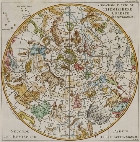
**_Hemisphaerium Coeli Boreale_** – Nuremberg, 1742
# **_Hemisphaerium Coeli Australe_** – Nuremberg, 1742
# Northern and Southern Copper-Engraved Planispheres
Johann Doppelmayr (~1671-1750)
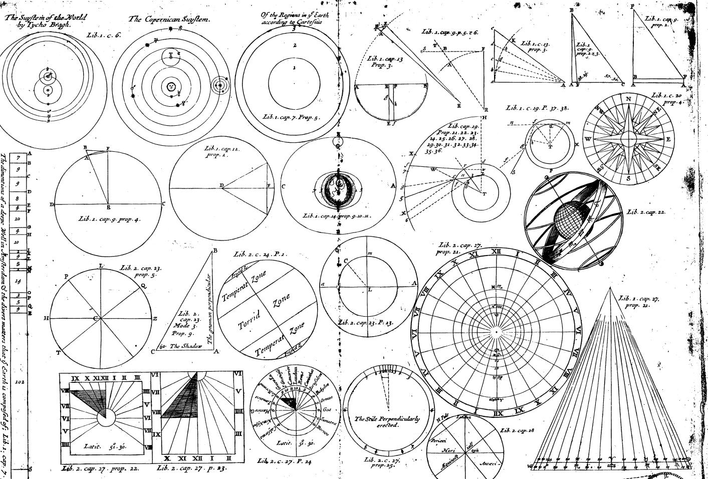
The great celestial atlases were not the only atlases produced. Several significant works were produced in the 17th and 18th centuries that included numerous charts comparing various solar system theories by Ptolemy, Copernicus and Tycho Brahe as well as other solar system phenomena. These often included planispheres and sometimes simple celestial atlases.
Ignace-Gaston Pardies produced an interesting set of charts in 1673. Instead of centering each chart on a constellation as Piccolomini, Galluci, Bayer, Schiller and Hevelius had done, he simply imagined the Earth surrounded by a celestial “cube” and produced six charts – one for each face of this cube. Two of the sides represented the sky around the northern and southern equatorial poles. The other four sides were centered on the equator and divided into the four seasons based on the Summer and Winter solstices and the Vernal and Autumnal equinoxes.
Johann Doppelmayr produced a similar set of charts which he published as part of his _Atlas Coelestis_. His atlas also included two sets of planispheres, one set centered on the ecliptical poles and a second set centered on the equatorial poles. The latter appear here. Note that the copper plates were probably engraved about 1720, but knowing how long it took to publish such works in the 18th century, the stars were depicted with their equatorial coordinates for the year 1730. Doppelmayr included tables to calculate the precession of the Earth’s poles so that the actual positions could be determined for any given year within a few years before or after 1730. This was fortuitous since his atlas didn’t actually get published until 1741.
|||
|---|---|
||A small atlas of 54 copper-engraved charts was produced by Corbinianus Thomas in 1730. These small charts were centered on individual constellations and paled in scope compared to those of Flamsteed published the year before.|
**19th Century: A Quick Apex Followed by Descent**
The 19th century started off with the last of the four great celestial atlases. In 1801, Johann Elert Bode published the most spectacular atlas of its kind. The charts somewhat resembled Flamsteed’s but were larger than in any previous star atlas and crowded with content. Bode increased the number of stars by another factor of six to more than 17,000 and identified hundreds of double stars. In addition to Charles Messier’s 100 bright nebulae, Bode included all 2,500 nebulae discovered by William Herschel in the late 18th century.
After Bode’s atlas, the artistic and scientific content of celestial atlases split. Atlases for scientific work became more detailed, but without the beautiful artwork of the constellation figures. To meet the popular needs of the public, atlases were simplified, and the constellation figures were less ornate, sometimes only shadowy or missing altogether. The first American atlas, published by Elijah Burritt in 1835, was the last major work of its kind. Burritt displayed the sky on four seasonal charts plus two polar charts with prominent constellation figures, similar to what Pardies had done in 1674 and Doppelmayr in 1742, except that Burritt’s charts resembled globe gores and calottes as opposed to the six sides of a celestial cube used by Pardies and Doppelmayr. Burritt’s charts were excellent for novice sky watchers and students using their naked eyes, but essentially useless for serious astronomy. It was the last significant atlas to include prominent constellation figures.

Bode Flamsteed Bayer
**_Uranographia_** – Berlin, 1801
Atlas of 20 Celestial Copper-Engraved Charts
Johann Elert Bode (1747-1826)
The fourth and last of the great celestial atlases, _Uranographia_, was published in 1801 by Johann Elert Bode. Bode had published one of the small versions of Flamsteed’s atlas in 1782, but Uranographia represented a whole new level of science.
Like Flamsteed, Bode only provided charts for the portion of the sky visible from central Europe, and like Flamsteed, Bode used equatorial coordinates and constellation figures. But Bode’s charts were physically twice the area of Flamsteed’s charts and were absolutely crowded with content in comparison. Bode covered the heavens in only 18 charts compared with Flamsteed’s 25, but on those charts he included 17,000 stars – six times as many as Flamsteed. He also included numerous new constellations, many of them invented by Bode just for _Uranographia_.
Unlike Flamsteed, Bode included nebulae – lots of them! In addition to the list of 100 published by Charles Messier in 1781, Bode included the 2,500 nebulae cataloged by William Herschel in the late 18th century. He also restored the Milky Way and systematically identified hundreds of stars with a symbol indicating that they were telescopic doubles.
The chart from _Uranographia_ on display here covers the northern polar area. Aside from the fact that it appears inverted from Flamsteed’s chart of the northern polar area, note that it covers a somewhat different area – the borders are not in the same star fields. Bayer’s chart of Cepheus – a central figure on the charts by Bode and Flamsteed, is also provided for comparison.
The advances from Bayer (1603) to Flamsteed (1729) are obvious, but a close examination of Bode’s chart (1801) shows that the advances in content are even greater for this last of the great celestial atlases. Here is an atlas that today’s amateur astronomer with a modern telescope could happily use for many years of heavenly exploration.

**_The Geography of the Heavens_** – New York, 1835
###### Atlas of 10 Celestial Copper-Engraved Charts
Elijah Burritt (1794-1838)
The first celestial atlas published in the United States was actually the last significant atlas to include prominent constellation figures. After this, constellation figures, if they appeared at all, were typically only shadowy figures among the stars of the heavens.
Elijah Burritt published his atlas for use by educators in America. It was very popular and was republished several times to meet demand.
Burritt’s celestial charts were a little like those of Pardies and Doppelmayr. There were circular charts for the northern and southern equatorial poles, and seasonal charts for the equatorial areas. But rather than distort the heavens with square charts, Burritt tapered his seasonal charts as if they were globe gores with polar calottes.
As became typical in the 19th century, Burritt’s charts were covered with nearly every constellation ever imagined by his predecessors, but the scale of these charts permitted only the brightest stars to be displayed and little if any scientific information was presented besides the rough positions and brightness of these stars.
Most charts and atlases published prior to 1820 were sold uncolored. Color was sometimes added later, but not usually by the original publisher. Burritt’s charts were an exception. Like the Jamieson atlas of 1822, these charts were hand colored with simple pastel washes at the time they were published.
**20th Century: The Modern Era**
Where the 19th century started off with the amazing _Uranographia_ by Bode in 1801, it was a century and a half before modern star atlases were produced for the amateur astronomer that could be considered an improvement.
For all intents and purposes, the modern era of celestial atlases was ushered in by Anton Becvar with his _Atlas Coeli 1950.0_ published in 1948 with star positions calculated for January 1, 1950. This atlas provided sixteen charts covering the entire sky. Not only did it include all stars to magnitude 7.75, but it also included thousands of deep sky objects and, unlike earlier atlases that usually used a single symbol to identify nebulae, it differentiated these by using different symbols to indicate what type of object each was. As expected for a modern scientific atlas, constellation figures were no longer included. But the boundaries for constellations were clearly identified.
This atlas became the prototype for all modern star atlases. Becvar’s symbols for deep sky objects have been used consistently by all subsequent authors. While advances have come rapidly, all modern atlases are evolutionary rather than revolutionary. They all are recognizable as having their roots in Becvar’s _Atlas Coeli 1950.0_.
l 1958 – Becvar issued a color version of _Atlas Coeli 1950.0_ entitled _Atlas of the Heavens_.
l 1981 – Wil Tirion published _Sky Atlas 2000.0_ with the first computer generated charts. All future atlases will have computer generated charts. _Sky Atlas 2000.0_ includes 26 charts with 43,000 stars and 2500 non-stellar objects.
l 1987 – Wil Tirion, Barry Rappaport and George Lovi published _Uranometria 2000.0_ including 473 charts with more than 332,000 stars and 10,300 non-stellar objects.
l 1997 – Roger Sinnott and Michael Perryman published _Millennium Star Atlas_ including 1,548 charts with more than a million stars and more than 10,600 non-stellar objects.
The information available now has exceeded that which can be reasonably portrayed in a printed atlas. Therefore, the most detailed charts are those that are available as computer software. Recent examples currently include more than 15 million stars.
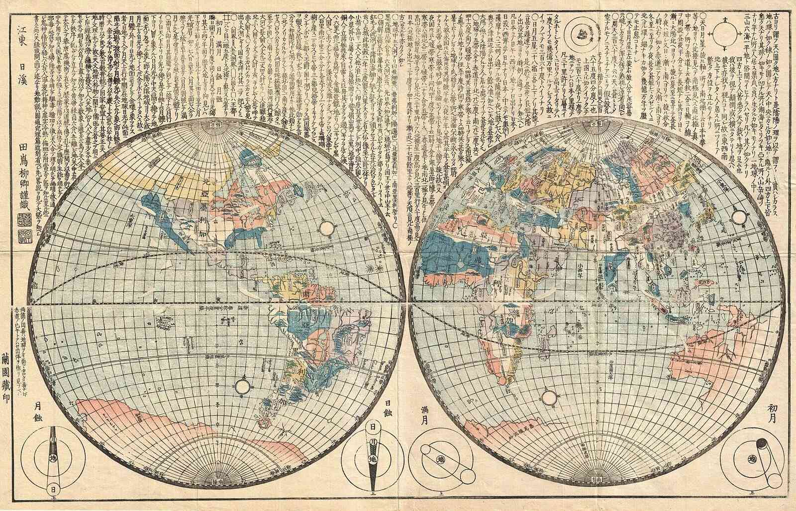
# Cosmography
Cosmographers would attempt to provide a descriptive model of the universe that included the Earth and the celestial realms, combining observations of the stars and attempt to make sense of the world's layout as a whole, from the Earth to the heavens.
In the age of classical antiquity, cosmography involved the creation of mappaemundi, or maps of the world, that often depicted both the terrestrial and celestial spheres. During the Renaissance, it became a more rigorous science with the advent of better observational tools and methods.
As scientific understanding progressed, particularly after the **16th and 17th centuries**, the disciplines of cosmography began to diverge into more specialized fields. Geography became focused on the Earth's surface and its features, cartography on map-making, and astronomy on the study of celestial bodies and phenomena. Cosmology, as it is understood today, emerged to explore the origins, structure, and dynamics of the universe, largely leaving behind the Earth-focused aspects of cosmography.
In the modern era, cosmography is considered a historical term, and its concepts are now encompassed within the separate disciplines of geography and astronomy.
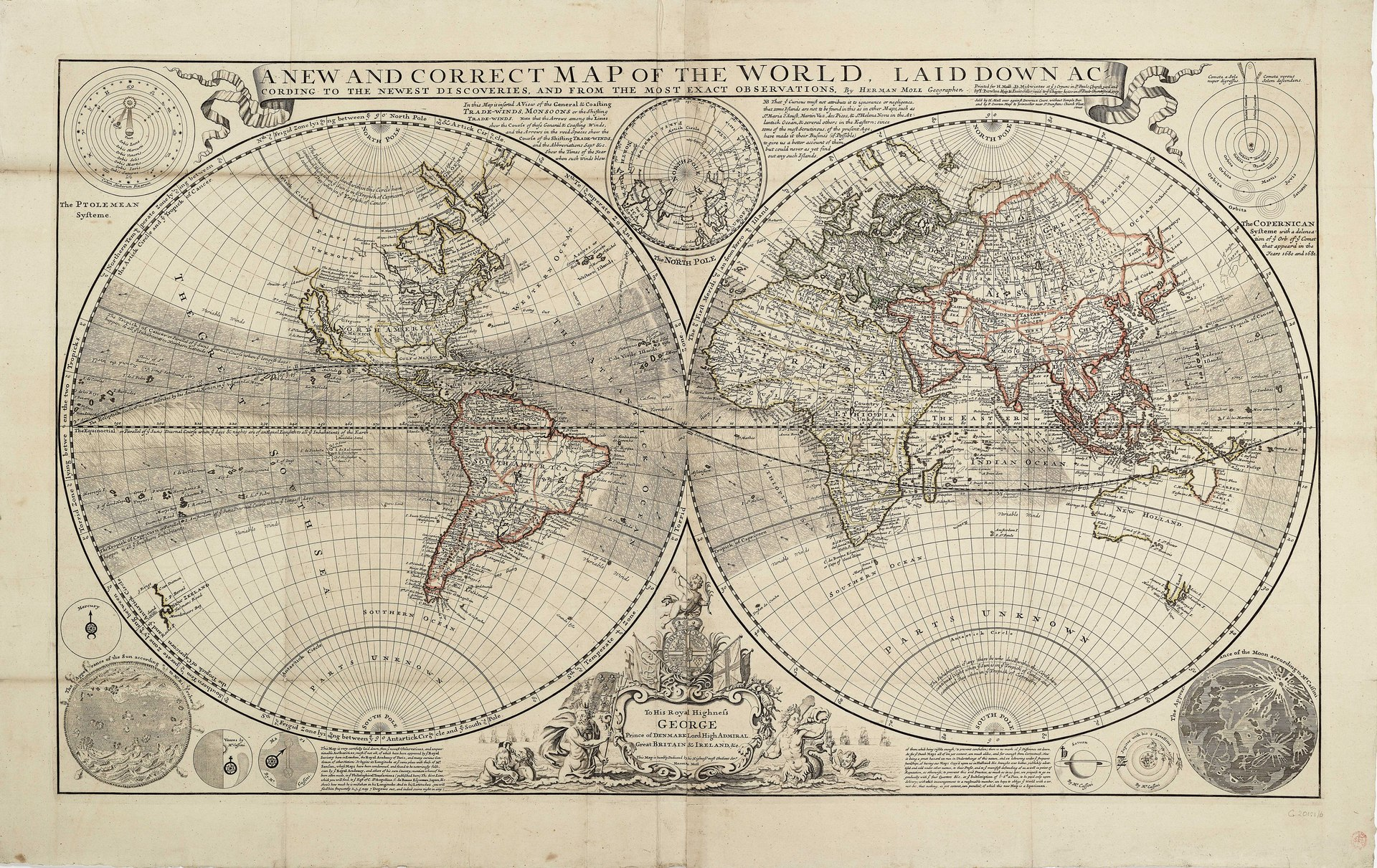
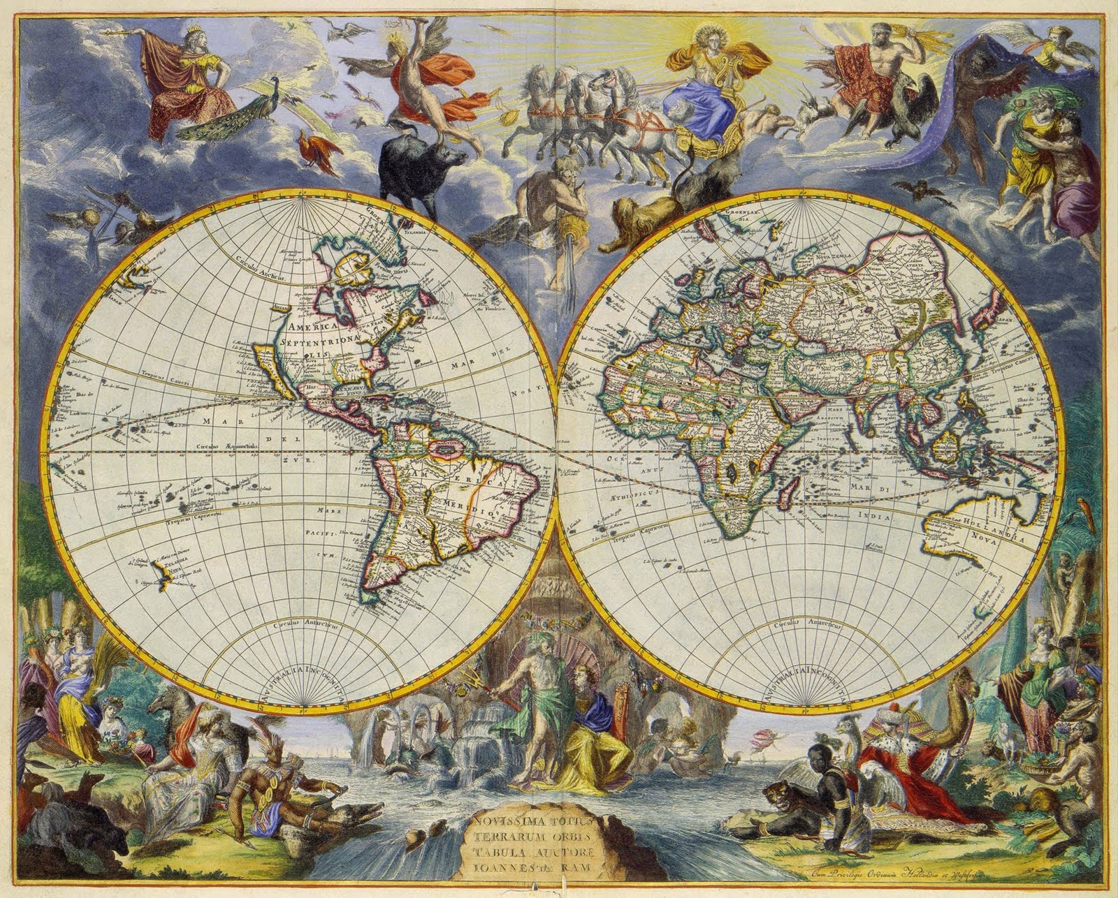
This double-hemisphere world map features insets of the celestial northern hemisphere and the celestial southern hemisphere, both of which show the mythological figures and objects of the constellations. Windheads and illustrations of a volcanic eruption, earthquake, tides, water-spouts, and a rainbow decorate the four corners of the composition. The map shows California as insular and traces the sailing routes of the explorers Magellan, Olivier van Noort, William Dampier, Abel Tasman, and Juan Gaetano. Nuremberg cartographer and map publisher Homann and his family later produced a number of celestial and selenographical (lunar) charts in conjunction with the Nuremberg astronomer and mathematician Johann Gabriel Doppelmayr (1677-1750). Many of these charts were featured in Doppelmayr's _Atlas coelestis_, which Homann's Heirs published in 17
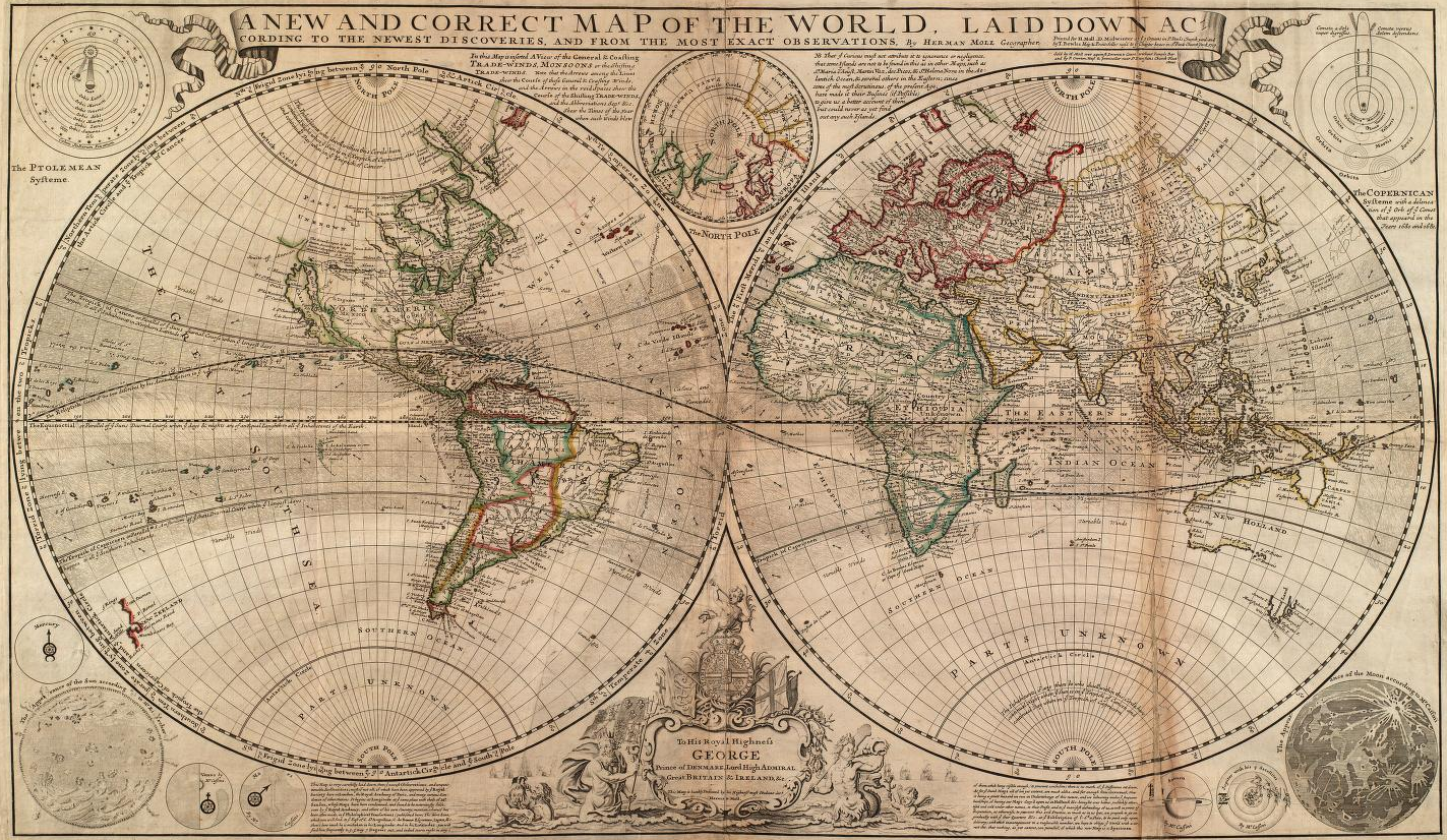
A new and correct map of the world, laid down according to the newest discoveries, and from the most exact observations, by Herman Moll, Geographer.2 sheets joined at the vertical centreline. Engraving coloured in outline. Scale: [circa 1:75,000,000]. A double hemisphere projection with the prime meridian through Ferro and a north polar inset. The Trade Winds are indicated and Dampier's track around the world is shown. Diagrams illustrate the Ptolemean and Copernican solar systems and the sun, moon and planets according to Kircher and Cassini. The cartouche of the dedication to Prince George of Denmark is decorated with mermen, flags and ships. There are text notes on the inaccuracies of Sanson and Dutch mapping. G201:1/6 World
[https://commons.wikimedia.org/wiki/Category:1700s_maps_of_the_world#/media/File:Orbis_terrarum_cognitus_hodiernis_Europaeis._NYPL464975.tiff](https://commons.wikimedia.org/wiki/Category:1700s_maps_of_the_world#/media/File:Orbis_terrarum_cognitus_hodiernis_Europaeis._NYPL464975.tiff)
[https://digitalcollections.nypl.org/items/309635e0-857b-0132-f796-58d385a7bbd0](https://digitalcollections.nypl.org/items/309635e0-857b-0132-f796-58d385a7bbd0)
```embed
title: "Fetching"
image: "data:image/svg+xml;base64,PHN2ZyBjbGFzcz0ibGRzLW1pY3Jvc29mdCIgd2lkdGg9IjgwcHgiICBoZWlnaHQ9IjgwcHgiICB4bWxucz0iaHR0cDovL3d3dy53My5vcmcvMjAwMC9zdmciIHZpZXdCb3g9IjAgMCAxMDAgMTAwIiBwcmVzZXJ2ZUFzcGVjdFJhdGlvPSJ4TWlkWU1pZCI+PGcgdHJhbnNmb3JtPSJyb3RhdGUoMCkiPjxjaXJjbGUgY3g9IjgxLjczNDEzMzYxMTY0OTQxIiBjeT0iNzQuMzUwNDU3MTYwMzQ4ODIiIGZpbGw9IiNlMTViNjQiIHI9IjUiIHRyYW5zZm9ybT0icm90YXRlKDM0MC4wMDEgNDkuOTk5OSA1MCkiPgogIDxhbmltYXRlVHJhbnNmb3JtIGF0dHJpYnV0ZU5hbWU9InRyYW5zZm9ybSIgdHlwZT0icm90YXRlIiBjYWxjTW9kZT0ic3BsaW5lIiB2YWx1ZXM9IjAgNTAgNTA7MzYwIDUwIDUwIiB0aW1lcz0iMDsxIiBrZXlTcGxpbmVzPSIwLjUgMCAwLjUgMSIgcmVwZWF0Q291bnQ9ImluZGVmaW5pdGUiIGR1cj0iMS41cyIgYmVnaW49IjBzIj48L2FuaW1hdGVUcmFuc2Zvcm0+CjwvY2lyY2xlPjxjaXJjbGUgY3g9Ijc0LjM1MDQ1NzE2MDM0ODgyIiBjeT0iODEuNzM0MTMzNjExNjQ5NDEiIGZpbGw9IiNmNDdlNjAiIHI9IjUiIHRyYW5zZm9ybT0icm90YXRlKDM0OC4zNTIgNTAuMDAwMSA1MC4wMDAxKSI+CiAgPGFuaW1hdGVUcmFuc2Zvcm0gYXR0cmlidXRlTmFtZT0idHJhbnNmb3JtIiB0eXBlPSJyb3RhdGUiIGNhbGNNb2RlPSJzcGxpbmUiIHZhbHVlcz0iMCA1MCA1MDszNjAgNTAgNTAiIHRpbWVzPSIwOzEiIGtleVNwbGluZXM9IjAuNSAwIDAuNSAxIiByZXBlYXRDb3VudD0iaW5kZWZpbml0ZSIgZHVyPSIxLjVzIiBiZWdpbj0iLTAuMDYyNXMiPjwvYW5pbWF0ZVRyYW5zZm9ybT4KPC9jaXJjbGU+PGNpcmNsZSBjeD0iNjUuMzA3MzM3Mjk0NjAzNiIgY3k9Ijg2Ljk1NTE4MTMwMDQ1MTQ3IiBmaWxsPSIjZjhiMjZhIiByPSI1IiB0cmFuc2Zvcm09InJvdGF0ZSgzNTQuMjM2IDUwIDUwKSI+CiAgPGFuaW1hdGVUcmFuc2Zvcm0gYXR0cmlidXRlTmFtZT0idHJhbnNmb3JtIiB0eXBlPSJyb3RhdGUiIGNhbGNNb2RlPSJzcGxpbmUiIHZhbHVlcz0iMCA1MCA1MDszNjAgNTAgNTAiIHRpbWVzPSIwOzEiIGtleVNwbGluZXM9IjAuNSAwIDAuNSAxIiByZXBlYXRDb3VudD0iaW5kZWZpbml0ZSIgZHVyPSIxLjVzIiBiZWdpbj0iLTAuMTI1cyI+PC9hbmltYXRlVHJhbnNmb3JtPgo8L2NpcmNsZT48Y2lyY2xlIGN4PSI1NS4yMjEwNDc2ODg4MDIwNyIgY3k9Ijg5LjY1Nzc5NDQ1NDk1MjQxIiBmaWxsPSIjYWJiZDgxIiByPSI1IiB0cmFuc2Zvcm09InJvdGF0ZSgzNTcuOTU4IDUwLjAwMDIgNTAuMDAwMikiPgogIDxhbmltYXRlVHJhbnNmb3JtIGF0dHJpYnV0ZU5hbWU9InRyYW5zZm9ybSIgdHlwZT0icm90YXRlIiBjYWxjTW9kZT0ic3BsaW5lIiB2YWx1ZXM9IjAgNTAgNTA7MzYwIDUwIDUwIiB0aW1lcz0iMDsxIiBrZXlTcGxpbmVzPSIwLjUgMCAwLjUgMSIgcmVwZWF0Q291bnQ9ImluZGVmaW5pdGUiIGR1cj0iMS41cyIgYmVnaW49Ii0wLjE4NzVzIj48L2FuaW1hdGVUcmFuc2Zvcm0+CjwvY2lyY2xlPjxjaXJjbGUgY3g9IjQ0Ljc3ODk1MjMxMTE5NzkzIiBjeT0iODkuNjU3Nzk0NDU0OTUyNDEiIGZpbGw9IiM4NDliODciIHI9IjUiIHRyYW5zZm9ybT0icm90YXRlKDM1OS43NiA1MC4wMDY0IDUwLjAwNjQpIj4KICA8YW5pbWF0ZVRyYW5zZm9ybSBhdHRyaWJ1dGVOYW1lPSJ0cmFuc2Zvcm0iIHR5cGU9InJvdGF0ZSIgY2FsY01vZGU9InNwbGluZSIgdmFsdWVzPSIwIDUwIDUwOzM2MCA1MCA1MCIgdGltZXM9IjA7MSIga2V5U3BsaW5lcz0iMC41IDAgMC41IDEiIHJlcGVhdENvdW50PSJpbmRlZmluaXRlIiBkdXI9IjEuNXMiIGJlZ2luPSItMC4yNXMiPjwvYW5pbWF0ZVRyYW5zZm9ybT4KPC9jaXJjbGU+PGNpcmNsZSBjeD0iMzQuNjkyNjYyNzA1Mzk2NDE1IiBjeT0iODYuOTU1MTgxMzAwNDUxNDciIGZpbGw9IiNlMTViNjQiIHI9IjUiIHRyYW5zZm9ybT0icm90YXRlKDAuMTgzNTUyIDUwIDUwKSI+CiAgPGFuaW1hdGVUcmFuc2Zvcm0gYXR0cmlidXRlTmFtZT0idHJhbnNmb3JtIiB0eXBlPSJyb3RhdGUiIGNhbGNNb2RlPSJzcGxpbmUiIHZhbHVlcz0iMCA1MCA1MDszNjAgNTAgNTAiIHRpbWVzPSIwOzEiIGtleVNwbGluZXM9IjAuNSAwIDAuNSAxIiByZXBlYXRDb3VudD0iaW5kZWZpbml0ZSIgZHVyPSIxLjVzIiBiZWdpbj0iLTAuMzEyNXMiPjwvYW5pbWF0ZVRyYW5zZm9ybT4KPC9jaXJjbGU+PGNpcmNsZSBjeD0iMjUuNjQ5NTQyODM5NjUxMTc2IiBjeT0iODEuNzM0MTMzNjExNjQ5NDEiIGZpbGw9IiNmNDdlNjAiIHI9IjUiIHRyYW5zZm9ybT0icm90YXRlKDEuODY0NTcgNTAgNTApIj4KICA8YW5pbWF0ZVRyYW5zZm9ybSBhdHRyaWJ1dGVOYW1lPSJ0cmFuc2Zvcm0iIHR5cGU9InJvdGF0ZSIgY2FsY01vZGU9InNwbGluZSIgdmFsdWVzPSIwIDUwIDUwOzM2MCA1MCA1MCIgdGltZXM9IjA7MSIga2V5U3BsaW5lcz0iMC41IDAgMC41IDEiIHJlcGVhdENvdW50PSJpbmRlZmluaXRlIiBkdXI9IjEuNXMiIGJlZ2luPSItMC4zNzVzIj48L2FuaW1hdGVUcmFuc2Zvcm0+CjwvY2lyY2xlPjxjaXJjbGUgY3g9IjE4LjI2NTg2NjM4ODM1MDYiIGN5PSI3NC4zNTA0NTcxNjAzNDg4NCIgZmlsbD0iI2Y4YjI2YSIgcj0iNSIgdHJhbnNmb3JtPSJyb3RhdGUoNS40NTEyNiA1MCA1MCkiPgogIDxhbmltYXRlVHJhbnNmb3JtIGF0dHJpYnV0ZU5hbWU9InRyYW5zZm9ybSIgdHlwZT0icm90YXRlIiBjYWxjTW9kZT0ic3BsaW5lIiB2YWx1ZXM9IjAgNTAgNTA7MzYwIDUwIDUwIiB0aW1lcz0iMDsxIiBrZXlTcGxpbmVzPSIwLjUgMCAwLjUgMSIgcmVwZWF0Q291bnQ9ImluZGVmaW5pdGUiIGR1cj0iMS41cyIgYmVnaW49Ii0wLjQzNzVzIj48L2FuaW1hdGVUcmFuc2Zvcm0+CjwvY2lyY2xlPjxhbmltYXRlVHJhbnNmb3JtIGF0dHJpYnV0ZU5hbWU9InRyYW5zZm9ybSIgdHlwZT0icm90YXRlIiBjYWxjTW9kZT0ic3BsaW5lIiB2YWx1ZXM9IjAgNTAgNTA7MCA1MCA1MCIgdGltZXM9IjA7MSIga2V5U3BsaW5lcz0iMC41IDAgMC41IDEiIHJlcGVhdENvdW50PSJpbmRlZmluaXRlIiBkdXI9IjEuNXMiPjwvYW5pbWF0ZVRyYW5zZm9ybT48L2c+PC9zdmc+"
description: "Fetching https://digitalcollections.nypl.org/items/309635e0-857b-0132-f796-58d385a7bbd0"
url: "https://digitalcollections.nypl.org/items/309635e0-857b-0132-f796-58d385a7bbd0"
```
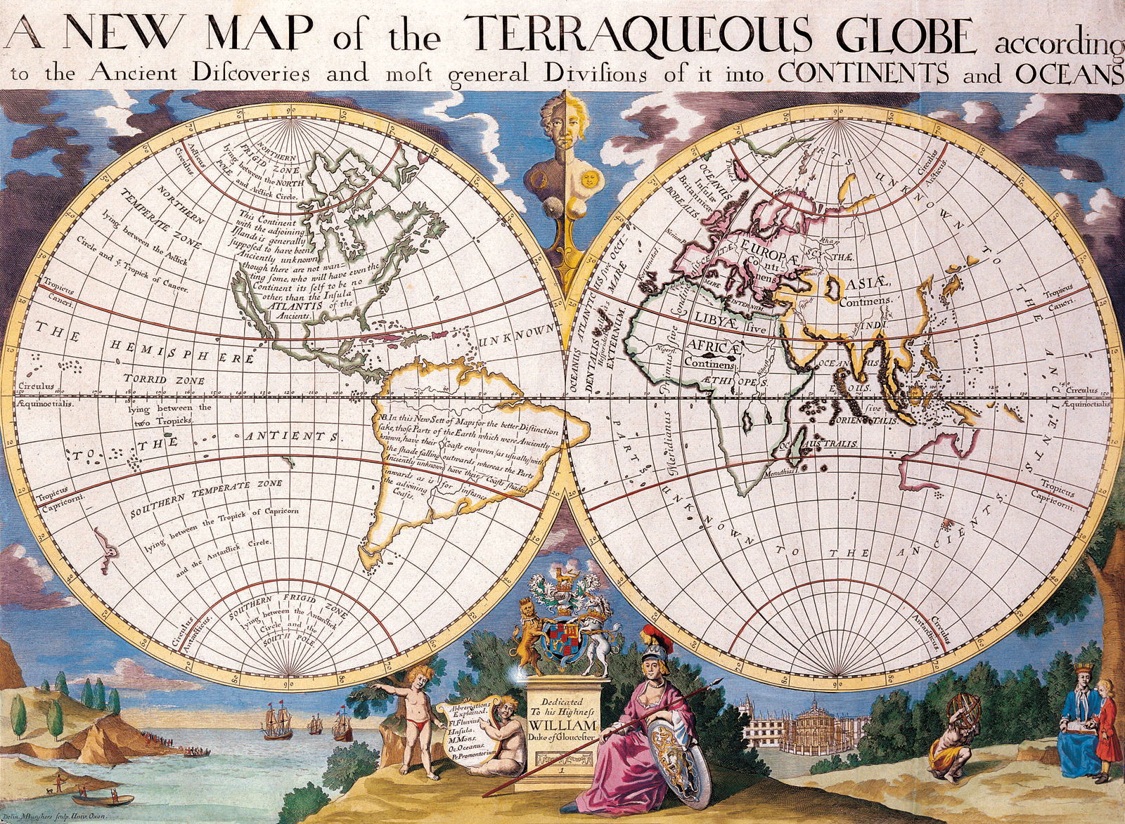
A NEW MAP of the TERRAQUEOUS GLOBE according to the Ancient Diſcoveries and moſt general Diviſions of it into CONTINENTS and OCEANS. Published in Oxford. Dedicated to Wiliam, Duke of Glouchester. Similar to National Library of Australia, NK 4620. Hand Colored.
[
More details](https://commons.wikimedia.org/wiki/File:EAMC_132_-_a_new_and_correct_map_of_the_world.png)
_A new and correct map of the world, laid down according to the newest discoveries, and from the most exact observations_ Insets clockwise from left: The Ptolemean system -- The North Pole -- The Copernican system with a deleneation of y'e Comet that appeared in the years 1680 and 1681 -- The appearance of the Moon according to Mr. Cassini -- Jupiter with his 4 satellies / by Mr. Cassini -- Saturn / by Mr. Cassini -- Mars / by Mr. Cassini -- Venus / by Mr. Cassini -- The appearance of the Sun according to Mr. Kircher -- Mercury. Title in banner. Dedication: To his royal highness George, Prince of Denmark, Lord High Admiral Great Britain & Ireland &c. This map is humbly dedicated by his Highness' most obedient ser't. Herman Moll." Dedication in decorated title cartouche, depicting Neptune and other sea beings, with masted ships in background. Hand-colored copper engraving, printed on chain-lined paper.
- Contains 8 pages of text and 173 double-page large folio charts, colored by a contemporary hand. Citation/Reference: Sabin 95631 Most of the maps bear the imprint of Samuel Thornton, but some were issued by John Thornton, and others. The volumes may be a compilation from several sources, including John Thornton's Atlas maritimus.--cf. Bookseller's description inserted in v. 1; Sabin 95631; and Phillips 2833, 3455. Includes representations of Europe, Asia, America and Africa.
[https://www.loc.gov/resource/g3200m.gct00242/?sp=1&st=slideshow](https://publish.obsidian.md/#)
[https://www.loc.gov/resource/g3200m.gct00242/?sp=1&st=slideshow](https://www.loc.gov/resource/g3200m.gct00242/?sp=1&st=slideshow)
```embed
title: "Novissima totius orbis tabula / per Ioannes Loots"
image: "https://tile.loc.gov/storage-services/service/gmd/gmd3m/g3200m/g3200m/gct00242/ca000001.gif"
description: "Nautical charts with numerous place-names along coastlines. Depths shown by soundings. Title from citation in Philip Lee Phillips’ A list of geographical atlases, p. 246. Most maps in Dutch; text and titles in Dutch, French, English, or Latin on some maps. List of geographical atlases in the Library of Congress, 3464 Available also through the Library of Congress Web site as a raster image. LC copy annotated in pencil on some maps. Each double page map glued to the following map, with the first and last pages backed by blue paper. LC copy bound in red leather. Copy imperfect: spine and front board loose, some maps vertically fold-lined at center and taped."
url: "https://www.loc.gov/resource/g3200m.gct00242/?sp=1&st=slideshow"
```
Delisle, Guillaume (1675-1726). Cartographer Buache, Philippe (1700-1773). Cartographer Dezauche,


.png)


## **REFERENCE**S
Geokov. Map Projections: Types and Distortion Patterns. 2014. Web access 28 November 2014. [http://geokov.com/education/map-projection.aspx](http://geokov.com/education/map-projection.aspx)
Furuti, Carlos. Map Projections: Cylindrical Projections. 2 December 2013. Web access 28 November 2014. [http://www.progonos.com/furuti/MapProj/Dither/ProjCyl/projCyl.html](http://www.progonos.com/furuti/MapProj/Dither/ProjCyl/projCyl.html)
Furuti, Carlos. Map Projections: Conic Projections. 13 December 2013. Web access 28 November 2014. [http://www.progonos.com/furuti/MapProj/Dither/ProjCon/projCon.html](http://www.progonos.com/furuti/MapProj/Dither/ProjCon/projCon.html)
Šavrič, B., Patterson, T., & Jenny, B. (2019). [The equal earth map projection](https://www.geographyrealm.com/equal-earth-map-projection/). _International Journal of Geographical Information Science_, _33_(3), 454-465. [https://doi.org/10.1080/13658816.2018.1504949](https://doi.org/10.1080/13658816.2018.1504949)
Almagià, Roberto “Il primato di Firenze negli studi geografici durante i secoli XV e XVI,” Atti della Società per il Progresso delle Scienze, 18 (1930)[Google Scholar](https://scholar.google.com/scholar_lookup?title=Il+primato+di+Firenze+negli+studi+geografici+durante+i+secoli+XV+e+XVI&author=Almagi%C3%A0+Roberto&publication+year=1930&journal=Atti+della+Societ%C3%A0+per+il+Progresso+delle+Scienze&volume=18)
Apain, Peter, Cosmographicus liber a Petro Apiano mathematico studiose collecuts (Landshut: Johann Weiβenburger, 1524).[CrossRef](https://dx.doi.org/10.5479/sil.67050.39088001925148)[Google Scholar](https://scholar.google.com/scholar_lookup?title=Cosmographicus+liber+a+Petro+Apiano+mathematico+studiose+collecuts&author=Apain+Peter&publication+year=1524)
Bacon, Francis, Francisci de Verulamio, Summi Angliae Cancellarii, Instauratio magna (London: Jo. Billius, 1620)[Google Scholar](https://scholar.google.com/scholar_lookup?title=Francisci+de+Verulamio%2C+Summi+Angliae+Cancellarii%2C+Instauratio+magna&author=Bacon+Francis&publication+year=1620)
Bacon, FrancisNew Atlantis and The Great Instauration, ed. Weinberger, Jerry (Wheeling, Ill.: Harlan Davidson, 1989).[Google Scholar](https://scholar.google.com/scholar_lookup?title=New+Atlantis+and+The+Great+Instauration&author=Bacon+Francis&author=Weinberger+Jerry&publication+year=1989)
Bacon, FrancisThe Great Instauration [1620][Google Scholar]([https://scholar.google.com/scholar_lookup?title=The+Great+Instauration&author=Bacon+Francis&publication+year=1620](https://scholar.google.com/scholar_lookup?title=The+Great+Instauration&author=Bacon+Francis&publication+year=1620))
Baron, Hans “The Querelle of the Ancients and the Moderns as a Problem for Present Renaissance Scholarship,” Journal of the History of Ideas, 20 (1959)[CrossRef](https://dx.doi.org/10.2307/2707964)[Google Scholar](https://scholar.google.com/scholar_lookup?title=The+Querelle+of+the+Ancients+and+the+Moderns+as+a+Problem+for+Present+Renaissance+Scholarship&author=Baron+Hans&publication+year=1959&journal=Journal+of+the+History+of+Ideas&volume=20&doi=10.2307%2F2707964)
Baron, , In Search of Florentine Civic Humanism: Essays on the Transition from Medieval to Modern Thought, vol. 2 (Princeton, N.J.: Princeton University Press, 1988).[Google Scholar](https://scholar.google.com/scholar_lookup?title=In+Search+of+Florentine+Civic+Humanism%3A+Essays+on+the+Transition+from+Medieval+to+Modern+Thought&author=Baron+&publication+year=1988)
Bodin, Jean, I. Bodini methodus ad facilem historiarum cognitionem [1566] (Amsterdam: Jo. Ravesteiny, 1650; repr. Aalen: Scientia, 1967).[Google Scholar](https://scholar.google.com/scholar_lookup?title=I.+Bodini+methodus+ad+facilem+historiarum+cognitionem&author=Bodin+Jean&publication+year=1566)
Boxer, Charles R.The Portuguese Seaborne Empire, 1415–1825, 2 vols. (London: Alfred A. Knopf, 1969)[Google Scholar](https://scholar.google.com/scholar_lookup?title=The+Portuguese+Seaborne+Empire%2C+1415%E2%80%931825&author=Boxer+CharlesR.&publication+year=1969)
Broc, NumaLa géographie de la Renaissance, 2nd ed. (Paris: Éditions du Comité des Travaux historiques et scientifiques, 1986).[Google Scholar](https://scholar.google.com/scholar_lookup?title=La+g%C3%A9ographie+de+la+Renaissance&author=Broc+Numa&publication+year=1986)
Camers, Joannes, Io. Camertis ordinis Minorum, sacrae Theologiae professoris Antilogia, idest, locorum quorundam apud Iulium Solinum a Ioachimo Vadiano Helvetio confutatorum, amica defensio (Vienna: Io. Singrenius, 1522)[Google Scholar](https://scholar.google.com/scholar_lookup?title=Io.+Camertis+ordinis+Minorum%2C+sacrae+Theologiae+professoris+Antilogia%2C+idest%2C+locorum+quorundam+apud+Iulium+Solinum+a+Ioachimo+Vadiano+Helvetio+confutatorum%2C+amica+defensio&author=Camers+Joannes&publication+year=1522)
Camers, JohannesIn C. Iulii Solini Polyistora Enarrationes (Vienna: Io. Singrenius, 1520)[Google Scholar](https://scholar.google.com/scholar_lookup?title=In+C.+Iulii+Solini+Polyistora+Enarrationes&author=Camers+Johannes&publication+year=1520)
Cassini, JacquesTraité de la grandeur et de la figure de la Terre, par M. Cassini de l’Académie Royale des Sciences (Amsterdam: Pierre de Coup, 1723).[Google Scholar](https://scholar.google.com/scholar_lookup?title=Trait%C3%A9+de+la+grandeur+et+de+la+figure+de+la+Terre%2C+par+M.+Cassini+de+l%E2%80%99Acad%C3%A9mie+Royale+des+Sciences&author=Cassini+Jacques&publication+year=1723)
Cline, Harold F. “The Relaciones Geográficas of the Spanish Indies, 1577–1648,” in Handbook of Middle American Indians, vol. 12 (Guide to Ethnohistorical Sources, 1), ed. Cline, Harold F. (Austin: University of Texas, 1972)[Google Scholar](https://scholar.google.com/scholar_lookup?title=Handbook+of+Middle+American+Indians&author=Cline+HaroldF.&author=Cline+HaroldF.&publication+year=1972)
Columbus, ChristopherTextos y documentos completos, 3rd ed., ed. Varela, Consuelo (Madrid: Alianza, 1989).[Google Scholar](https://scholar.google.com/scholar_lookup?title=Textos+y+documentos+completos&author=Columbus+Christopher&author=Varela+Consuelo&publication+year=1989)
Copernicus, NicholasNicolai Copernici Torinensis De revolutionibus orbium coelestium libri VI (Nürnberg: Io. Petreius, 1543).[CrossRef](https://dx.doi.org/10.5479/sil.305973.39088000648568)[Google Scholar](https://scholar.google.com/scholar_lookup?title=Nicolai+Copernici+Torinensis+De+revolutionibus+orbium+coelestium+libri+VI&author=Copernicus+Nicholas&publication+year=1543)
da Mota, A. Teixeira “Some Notes on the Organization of Hydrographical Services in Portugal before the Beginning of the Nineteenth Century,” Imago Mundi, 28 (1978)[Google Scholar](https://scholar.google.com/scholar_lookup?title=Some+Notes+on+the+Organization+of+Hydrographical+Services+in+Portugal+before+the+Beginning+of+the+Nineteenth+Century&author=da+Mota+A.+Teixeira&publication+year=1978&journal=Imago+Mundi&volume=28)
de Dainville, FrançoisLa géographie des humanistes (Paris: Beauchesne et ses fils, 1940; repr. Geneva: Slatkine, 1969).[Google Scholar](https://scholar.google.com/scholar_lookup?title=La+g%C3%A9ographie+des+humanistes&author=de+Dainville+Fran%C3%A7ois&publication+year=1940)
Dekker, Elly and Krogt, Peter, Globes from the Western World (London: Zwemmer, 1993).[Google Scholar](https://scholar.google.com/scholar_lookup?title=Globes+from+the+Western+World&author=Dekker+Elly&author=Krogt+Peter&publication+year=1993)
Diffie, Bailey W. and Winius, George D., Foundations of the Portuguese Empire, 1415–1580 (Europe and the World in the Age of Expansion, 1) (Minneapolis: University of Minnesota Press, 1977).[Google Scholar](https://scholar.google.com/scholar_lookup?title=Foundations+of+the+Portuguese+Empire%2C+1415%E2%80%931580&author=Diffie+BaileyW.&author=Winius+GeorgeD.&publication+year=1977)
Eliot Morison, SamuelAdmiral of the Ocean Sea: A Life of Christopher Columbus (Boston: Little, Brown, 1951).[Google Scholar](https://scholar.google.com/scholar_lookup?title=Admiral+of+the+Ocean+Sea%3A+A+Life+of+Christopher+Columbus&author=Eliot+Morison+Samuel&publication+year=1951)
Emilio Taviani, PaoloCristoforo Colombo: La genesi della grande scoperta, 2 vols. (Novara: Istituto Geografico de Agostini, 1974).[Google Scholar](https://scholar.google.com/scholar_lookup?title=Cristoforo+Colombo%3A+La+genesi+della+grande+scoperta&author=Emilio+Taviani+Paolo&publication+year=1974)
Fernandez-Armesto, FelipeColumbus (Oxford: Oxford University Press, 1991).[Google Scholar](https://scholar.google.com/scholar_lookup?title=Columbus&author=Fernandez-Armesto+Felipe&publication+year=1991)
Galilei, Galileo “Trattato della sfera ovvero Cosmografia,” in Le opere di Galileo Galilei, ed. , Giuseppe Saragat, 20 vols. (Florence: G. Barbèra, 1968).[Google Scholar](https://scholar.google.com/scholar_lookup?title=Le+opere+di+Galileo+Galilei&author=Galilei+Galileo&author=+GiuseppeSaragat&publication+year=1968)
Gallois, LucienLes géographes allemands de la Renaissance (Paris: E. Leroux, 1890)[Google Scholar](https://scholar.google.com/scholar_lookup?title=Les+g%C3%A9ographes+allemands+de+la+Renaissance&author=Gallois+Lucien&publication+year=1890)
Graf-Stuhlhofer, FranzHumanismus zwischen Hof und Universität: Georg Tannstetter (Collimitius) und sein wissenschaftliches Umfeld im Wien des frühen 16. Jahrhunderts (Schriftenreihe des Universitätsarchivs, 8) (Vienna: WUV-Universitätsverlag, 1996).[Google Scholar](https://scholar.google.com/scholar_lookup?title=Humanismus+zwischen+Hof+und+Universit%C3%A4t%3A+Georg+Tannstetter+(Collimitius)+und+sein+wissenschaftliches+Umfeld+im+Wien+des+fr%C3%BChen+16.+Jahrhunderts&author=Graf-Stuhlhofer+Franz&publication+year=1996)
Heinz Burmeister, KarlSebastian Münster: Versuch eines biographischen Gesamtbildes (Basel: Helbing and Lichtenhahn, 1969)[Google Scholar](https://scholar.google.com/scholar_lookup?title=Sebastian+M%C3%BCnster%3A+Versuch+eines+biographischen+Gesamtbildes&author=Heinz+Burmeister+Karl&publication+year=1969)
Heinz Burmeister, Karl, ed. and trans., Briefe Sebastian Münsters, lat.-dt. (Frankfurt am Main: Insel, 1964)[Google Scholar](https://scholar.google.com/scholar_lookup?title=Briefe+Sebastian+M%C3%BCnsters%2C+lat.-dt&author=Heinz+Burmeister+Karl&publication+year=1964)
Hooykaas, Reijer “The Rise of Modern Science: When and Why?,” British Journal for the History of Science, 20 (1987).[CrossRef](https://dx.doi.org/10.1017/S0007087400024225)[Google Scholar](https://scholar.google.com/scholar_lookup?title=The+Rise+of+Modern+Science%3A+When+and+Why%3F&author=Hooykaas+Reijer&publication+year=1987&journal=British+Journal+for+the+History+of+Science&volume=20&doi=10.1017%2FS0007087400024225)
Kant, ImmanuelImmanuel Kant’s Physische Geographie, 4 vols. (Mainz and Hamburg: G. Vollmer, 1801)[Google Scholar](https://scholar.google.com/scholar_lookup?title=Immanuel+Kant%E2%80%99s+Physische+Geographie&author=Kant+Immanuel&publication+year=1801)
Karrow, R. W. Jr., ed., Abraham Ortelius (1527–1598), cartographe et humaniste (Turnhout: Brepols, 1998).[Google Scholar](https://scholar.google.com/scholar_lookup?title=Abraham+Ortelius+(1527%E2%80%931598)%2C+cartographe+et+humaniste&author=Karrow+R.+W.&publication+year=1998)
Kollauer, Johann to Celtis, Konrad, Antwerp, 4 May 1503, in Der Briefwechsel des Konrad Celtis, ed. Rupprich, Hans (Humanistenbriefe, 3) (Munich: C. H. Beck, 1934)[Google Scholar](https://scholar.google.com/scholar_lookup?title=Der+Briefwechsel+des+Konrad+Celtis&author=Kollauer+Johann&author=Celtis+Konrad&author=Rupprich+Hans&publication+year=1503)
Konvitz, Josef W.Cartography in France, 1660–1848: Science, Engineering, and Statecraft (Chicago: University of Chicago Press, 1987).[Google Scholar](https://scholar.google.com/scholar_lookup?title=Cartography+in+France%2C+1660%E2%80%931848%3A+Science%2C+Engineering%2C+and+Statecraft&author=Konvitz+JosefW.&publication+year=1987)
Lamb, UrsulaCosmographers and Pilots of the Spanish Maritime Empire (Variorum Collected Studies Series, 499) (Aldershot: Ashgate, 1995).[Google Scholar](https://scholar.google.com/scholar_lookup?title=Cosmographers+and+Pilots+of+the+Spanish+Maritime+Empire&author=Lamb+Ursula&publication+year=1995)
Le Roy, LouisDe la vicissitude ov variete des choses en l’vnivers … Par Loys Le Roy, dict Regivs. Av Treschrestien Roy de France, et de Poloigne Henry III. du nom (Paris: Chez Pierre l’Huillier, 1577).[Google Scholar](https://scholar.google.com/scholar_lookup?title=De+la+vicissitude+ov+variete+des+choses+en+l%E2%80%99vnivers+%E2%80%A6+Par+Loys+Le+Roy%2C+dict+Regivs.+Av+Treschrestien+Roy+de+France%2C+et+de+Poloigne+Henry+III.+du+nom&author=Le+Roy+Louis&publication+year=1577)
Leporace, Tullia G. ed., Il mappamondo di Fra Mauro (Venice: Istituto Poligrafico dello Stato, 1954).[Google Scholar](https://scholar.google.com/scholar_lookup?title=Il+mappamondo+di+Fra+Mauro&author=Leporace+TulliaG.&publication+year=1954)
Lestringant, FrankL’Atélier du cosmographe (Paris: Albin Michel, 1991), translated as Mapping the Renaissance World, trans. Fausett, David (Cambridge: Polity, 1994).[Google Scholar](https://scholar.google.com/scholar_lookup?title=L%E2%80%99At%C3%A9lier+du+cosmographe&author=Lestringant+Frank&author=Fausett+David&publication+year=1991)
Lyra, of NicolausPostilla super totam Bibliam [1492], 4 vols. (Frankfurt am Main, 1971)[Google Scholar](https://scholar.google.com/scholar_lookup?title=Postilla+super+totam+Bibliam&author=Lyra+ofNicolaus&publication+year=1492)
Martyr d’Anghiera, PetrusOpus epistolarum [1530], no. 130, quoted in Berchet, Guglielmo, ed., Fonti italiane per la storia della scoperta del Nuovo Mondo (Raccolta Colombiana), vol. 3, pt. 2 (Rome: Ministero della Pubblica Istruzione, 1893).[Google Scholar](https://scholar.google.com/scholar_lookup?title=Fonti+italiane+per+la+storia+della+scoperta+del+Nuovo+Mondo&author=Martyr+d%E2%80%99Anghiera+Petrus&author=Berchet+Guglielmo&publication+year=1530)
Maurolico, , Cosmographia … in tres dialogos distincta (Venice: Heirs of Lucantonio Giunta, 1543).[Google Scholar](https://scholar.google.com/scholar_lookup?title=Cosmographia+%E2%80%A6+in+tres+dialogos+distincta&author=Maurolico+&publication+year=1543)
Maurolico, FrancescoDialoghi tre della Cosmographia (ms. Rome, 1536), ed. Cioffarelli, Giovanni (forthcoming)[Google Scholar](https://scholar.google.com/scholar_lookup?title=Dialoghi+tre+della+Cosmographia&author=Maurolico+Francesco&author=Cioffarelli+Giovanni&publication+year=1536)
Mercator, GerardusChronologia, hoc est Temporum demonstratio exactissima, ab initio mundi usque ad annum domini M.D.LXVIII … (1st ed. 1569; Cologne: A. Birckmannus, 1579)[Google Scholar](https://scholar.google.com/scholar_lookup?title=Chronologia%2C+hoc+est+Temporum+demonstratio+exactissima%2C+ab+initio+mundi+usque+ad+annum+domini+M.D.LXVIII+%E2%80%A6&author=Mercator+Gerardus&publication+year=1569)
Moody, Ernest A. “John Buridan on the Habitability of the Earth,” Speculum, 16 (1941)[CrossRef](https://dx.doi.org/10.2307/2852841)[Google Scholar](https://scholar.google.com/scholar_lookup?title=John+Buridan+on+the+Habitability+of+the+Earth&author=Moody+ErnestA.&publication+year=1941&journal=Speculum&volume=16&doi=10.2307%2F2852841)
Mundy, Barbara E.Indigenous Cartography and the Maps of the Relaciones Geográficas (Chicago: University of Chicago Press, 1996).[Google Scholar](https://scholar.google.com/scholar_lookup?title=Indigenous+Cartography+and+the+Maps+of+the+Relaciones+Geogr%C3%A1ficas&author=Mundy+BarbaraE.&publication+year=1996)
Parry, J. H.The Age of Reconnaissance: Discovery, Exploration, and Settlement, 1450 to 1650 (Berkeley: University of California Press, 1981)[Google Scholar](https://scholar.google.com/scholar_lookup?title=The+Age+of+Reconnaissance%3A+Discovery%2C+Exploration%2C+and+Settlement%2C+1450+to+1650&author=Parry+J.+H.&publication+year=1981)
Perrault, CharlesParalelle des Anciens et des Modernes en ce qui regarde les arts et les sciences. Dialogues, 4 vols. (Paris: Jean Baptiste Coignard, 1688–96), vol. 1, 2nd ed.[Google Scholar](https://scholar.google.com/scholar_lookup?title=Paralelle+des+Anciens+et+des+Modernes+en+ce+qui+regarde+les+arts+et+les+sciences.+Dialogues&author=Perrault+Charles&publication+year=1688%E2%80%9396)
Peschel, O. and Ruge, Sophus, Geschichte der Erdkunde bis auf Alexander von Humboldt und Carl Ritter, 2nd ed. (Munich: R. Oldenbourg, 1877).[Google Scholar](https://scholar.google.com/scholar_lookup?title=Geschichte+der+Erdkunde+bis+auf+Alexander+von+Humboldt+und+Carl+Ritter&author=Peschel+O.&author=Ruge+Sophus&publication+year=1877)
Peschel, Oscar and Ruge, Sophus, in their Geschichte der Erdkunde (Munich: J. G. Cotta, 1865).[Google Scholar](https://scholar.google.com/scholar_lookup?title=Geschichte+der+Erdkunde&author=Peschel+Oscar&author=Ruge+Sophus&publication+year=1865)
Ptolemy, , Claudii Ptolemaei Alexandrini philosophi … De Geographia libri octo (Basel: Io. Froben, 1533).[Google Scholar](https://scholar.google.com/scholar_lookup?title=Claudii+Ptolemaei+Alexandrini+philosophi+%E2%80%A6+De+Geographia+libri+octo&author=Ptolemy+&publication+year=1533)
Randles, William G. L. “Classical Models of World Geography and Their Transformation Following the Discovery of America,” in The Classical Tradition and the Americas, ed. Haase, Wolfgang and Reinhold, Meyer (Berlin: Walter de Gruyter, 1994)[Google Scholar](https://scholar.google.com/scholar_lookup?title=The+Classical+Tradition+and+the+Americas&author=Randles+WilliamG.+L.&author=Haase+Wolfgang&author=Reinhold+Meyer&publication+year=1994)
Randles, William G. L. “The Evaluation of Columbus’ ‘India’ Project by Portuguese and Spanish Cosmographers in the Light of the Geographical Science of the Period,” Imago Mundi, 42 (1990).[CrossRef](https://dx.doi.org/10.1080/03085699008592691)[Google Scholar](https://scholar.google.com/scholar_lookup?title=The+Evaluation+of+Columbus%E2%80%99+%E2%80%98India%E2%80%99+Project+by+Portuguese+and+Spanish+Cosmographers+in+the+Light+of+the+Geographical+Science+of+the+Period&author=Randles+WilliamG.+L.&publication+year=1990&journal=Imago+Mundi&volume=42&doi=10.1080%2F03085699008592691)
Ronsin, Albert ed., La fortune d’un nom: AMERICA, Le baptême du Nouveau Monde à Saint-Dié-des Vosges, trans. Monat, Pierre (Grenoble: Jérôme Millon, 1991).[Google Scholar](https://scholar.google.com/scholar_lookup?title=La+fortune+d%E2%80%99un+nom%3A+AMERICA%2C+Le+bapt%C3%AAme+du+Nouveau+Monde+%C3%A0+Saint-Di%C3%A9-des+Vosges&author=Ronsin+Albert&author=Monat+Pierre&publication+year=1991)
Russell, PeterPrince Henry the Navigator (New Haven, Conn.: Yale University Press, 2000).[Google Scholar](https://scholar.google.com/scholar_lookup?title=Prince+Henry+the+Navigator&author=Russell+Peter&publication+year=2000)
Schäfer, ErnestoEl Consejo Real y Supremo de las Indias: Su historia, organización y labor administrativa hasta la terminación de la Casa de Austria, 2 vols. (Sevilla, 1935, 1947)[Google Scholar](https://scholar.google.com/scholar_lookup?title=El+Consejo+Real+y+Supremo+de+las+Indias%3A+Su+historia%2C+organizaci%C3%B3n+y+labor+administrativa+hasta+la+terminaci%C3%B3n+de+la+Casa+de+Austria&author=Sch%C3%A4fer+Ernesto&publication+year=1935)
Taylor, Eva G. R.The Haven-Finding Art: A History of Navigation from Odysseus to Captain Cook (New York: Abelard-Schuman, 1957)[Google Scholar](https://scholar.google.com/scholar_lookup?title=The+Haven-Finding+Art%3A+A+History+of+Navigation+from+Odysseus+to+Captain+Cook&author=Taylor+EvaG.+R.&publication+year=1957)
Taylor, Eva G. R.Tudor Geography, 1485–1583 (London: Methuen, 1930)[Google Scholar](https://scholar.google.com/scholar_lookup?title=Tudor+Geography%2C+1485%E2%80%931583&author=Taylor+EvaG.+R.&publication+year=1930)
Taylor, , Late Tudor and Early Stuart Geography, 1583–1650 (London: Methuen, 1934)[Google Scholar](https://scholar.google.com/scholar_lookup?title=Late+Tudor+and+Early+Stuart+Geography%2C+1583%E2%80%931650&author=Taylor+&publication+year=1934)
Taylor, , The Mathematical Practitioners of Tudor and Stuart England (London: Methuen, 1954).[Google Scholar](https://scholar.google.com/scholar_lookup?title=The+Mathematical+Practitioners+of+Tudor+and+Stuart+England&author=Taylor+&publication+year=1954)
Vadian, Joachim “Loca aliquot ex Pomponianis commentariis repetita, indicataque, in quibus censendis, et aestimandis Ioanni Camerti Theologo Minoritano, viro doctissimo, suis in Solinum enarrationibus, cum Ioachimo Vadiano non admodum convenit,” in Mela, Pomponius, Pomponii Melae De orbis situ libri tres, acuratissime emendati, una cum Commentariis Ioachimi Vadiani Helvetii castigatoribus … (Basel: A. Cratander, 1522)[Google Scholar](https://scholar.google.com/scholar_lookup?title=Pomponii+Melae+De+orbis+situ+libri+tres%2C+acuratissime+emendati%2C+una+cum+Commentariis+Ioachimi+Vadiani+Helvetii+castigatoribus+%E2%80%A6&author=Vadian+Joachim&author=Mela+Pomponius&publication+year=1522)
Vadian, JoachimPomponii Melae Hispani, libri de situ orbis tres, adiectis Ioachimi Vadiani in eosdem Scholiis … (Vienna: Io. Singrenius, 1518)[Google Scholar](https://scholar.google.com/scholar_lookup?title=Pomponii+Melae+Hispani%2C+libri+de+situ+orbis+tres%2C+adiectis+Ioachimi+Vadiani+in+eosdem+Scholiis+%E2%80%A6&author=Vadian+Joachim&publication+year=1518)
Vespucci, Amerigo “Mundus Novus,” in Letters from a New World: Amerigo Vespucci’s Discovery of America, ed. Formisano, Luciano, trans. Jacobson, David (New York: Marsilio, 1992).[Google Scholar](https://scholar.google.com/scholar_lookup?title=Letters+from+a+New+World%3A+Amerigo+Vespucci%E2%80%99s+Discovery+of+America&author=Vespucci+Amerigo&author=Formisano+Luciano&author=Jacobson+David&publication+year=1992)
Vogel, Klaus A. “Amerigo Vespucci und die Humanisten in Wien: Die Rezeption der geographischen Entdeckungen und der Streit zwischen Joachim Vadian und Johannes Camers über die Irrtümer der Klassiker,” Pirckheimer-Jahrbuch, 7 (1992).[Google Scholar](https://scholar.google.com/scholar_lookup?title=Amerigo+Vespucci+und+die+Humanisten+in+Wien%3A+Die+Rezeption+der+geographischen+Entdeckungen+und+der+Streit+zwischen+Joachim+Vadian+und+Johannes+Camers+%C3%BCber+die+Irrt%C3%BCmer+der+Klassiker&author=Vogel+KlausA.&publication+year=1992&journal=Pirckheimer-Jahrbuch&volume=7)
Vogel, Klaus A. “Das Problem der relativen Lage von Erd- und Wassersphäre im Mittelalter und die kosmographische Revolution,” Mitteilungen der Österreichischen Gesellschaft für Wissenschaftsgeschichte, 13 (1993).[Google Scholar](https://scholar.google.com/scholar_lookup?title=Das+Problem+der+relativen+Lage+von+Erd-+und+Wassersph%C3%A4re+im+Mittelalter+und+die+kosmographische+Revolution&author=Vogel+KlausA.&publication+year=1993&journal=Mitteilungen+der+%C3%96sterreichischen+Gesellschaft+f%C3%BCr+Wissenschaftsgeschichte&volume=13)
Vogel, Klaus A. “Neue Horizonte der Kosmographie: Die kosmographischen Bücherlisten Hartmann Schedels (um 1498) und Konrad Peutingers (1523),” Anzeiger des Germanischen National-museums, 67 (1991).[Google Scholar](https://scholar.google.com/scholar_lookup?title=Neue+Horizonte+der+Kosmographie%3A+Die+kosmographischen+B%C3%BCcherlisten+Hartmann+Schedels+(um+1498)+und+Konrad+Peutingers+(1523)%2C&author=Vogel+KlausA.&publication+year=1991&journal=Anzeiger+des+Germanischen+National-museums&volume=67)
Vogel, Klaus A. “Neue Welt Nirgendwo? Geographische und geschichtliche Horizonte der ‘Utopia’ des Thomas Morus,” in Vogel, Klaus, ed., Denkhorizonte und Handlungsspielräume: Historische Studien für Rudolf Vierhaus zum 70. Geburtstag (Göttingen: Wallstein, 1992).[Google Scholar](https://scholar.google.com/scholar_lookup?title=Denkhorizonte+und+Handlungsspielr%C3%A4ume%3A+Historische+Studien+f%C3%BCr+Rudolf+Vierhaus+zum+70.+Geburtstag&author=Vogel+KlausA.&author=Vogel+Klaus&publication+year=1992)
von Mzik, Hans ed. and trans., Des Klaudios Ptolemäus Einführung in die darstellende Erdkunde: Erster Teil (Vienna: Gerold and Co., 1938).[Google Scholar](https://scholar.google.com/scholar_lookup?title=Des+Klaudios+Ptolem%C3%A4us+Einf%C3%BChrung+in+die+darstellende+Erdkunde%3A+Erster+Teil&author=von+Mzik+Hans&publication+year=1938)
Waldseemüller, Martin, Cosmographiae introductio, cum quibusdam geometriae ac astronomiae principiis ad eam rem necessariis (St. Dié: G. and N. Lud, 1507)[Google Scholar](https://scholar.google.com/scholar_lookup?title=Cosmographiae+introductio%2C+cum+quibusdam+geometriae+ac+astronomiae+principiis+ad+eam+rem+necessariis&author=Waldseem%C3%BCller+Martin&publication+year=1507)
Waldseemüller, , The Cosmographiae Introductio of Martin Waldseemüller, ed. Fischer, Joseph, Wieser, Franz, and Herbermann, Charles George, trans. Burke, Edward (New York: United States Catholic Historical Society, 1907)[Google Scholar](https://scholar.google.com/scholar_lookup?title=The+Cosmographiae+Introductio+of+Martin+Waldseem%C3%BCller&author=Waldseem%C3%BCller+&author=Fischer+Joseph&author=Wieser+Franz&author=Herbermann+CharlesGeorge&author=Burke+Edward&publication+year=1907)
Watelet, Marcel ed., Gérard Mercator cosmographe, le temps et l’espace (Mariakerke: Vanmelle, 1994)[Google Scholar](https://scholar.google.com/scholar_lookup?title=G%C3%A9rard+Mercator+cosmographe%2C+le+temps+et+l%E2%80%99espace&author=Watelet+Marcel&publication+year=1994)
Waters, David W.The Art of Navigation in England in Elizabethan and Early Stuart Times (London: Hollis and Carter, 1958).[Google Scholar](https://scholar.google.com/scholar_lookup?title=The+Art+of+Navigation+in+England+in+Elizabethan+and+Early+Stuart+Times&author=Waters+DavidW.&publication+year=1958)
Wolff, Hans ed., Philipp Apian und die Kartographie der Renaissance (Bayerische Staatsbibliothek, Ausstellungskataloge, 50) (Munich: Anton H. Konrad, 1989).[Google Scholar](https://scholar.google.com/scholar_lookup?title=Philipp+Apian+und+die+Kartographie+der+Renaissance&author=Wolff+Hans&publication+year=1989)
Zandvliet, KeesMapping for Money: Maps, Plans and Topographic Paintings and their Role in Dutch Overseas Expansion During the 16th and 17th Centuries (Amsterdam: Batavian Lion International, 1998)[Google Scholar](https://scholar.google.com/scholar_lookup?title=Mapping+for+Money%3A+Maps%2C+Plans+and+Topographic+Paintings+and+their+Role+in+Dutch+Overseas+Expansion+During+the+16th+and+17th+Centuries&author=Zandvliet+Kees&publication+year=1998)
Zurla, PlacidoIl mappamondo di Fra Mauro Camaldolese (Venice, 1806).[Google Scholar](https://scholar.google.com/scholar_lookup?title=Il+mappamondo+di+Fra+Mauro+Camaldolese&author=Zurla+Placido&publication+year=1806)