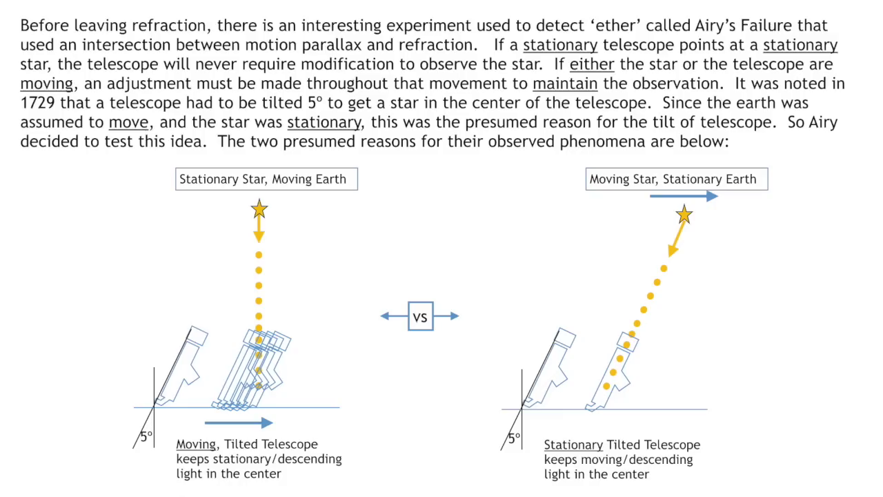
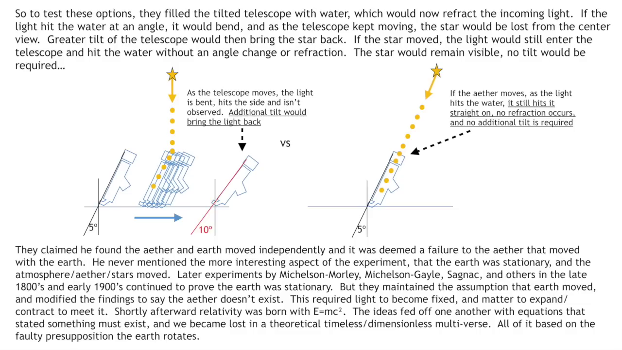
69 Miles Per Degree
[Sky Mile Slide Deck](https://publish.obsidian.md/shanesql/Sky+Mile+Slide+Deck)
[The Sky Mile Presentation](https://publish.obsidian.md/shanesql/The+Sky+Mile+Presentation)
[Sidereal Solar and Lunar Time](https://publish.obsidian.md/shanesql/Sidereal+Solar+and+Lunar+Time)
[Coordinate Systems](https://publish.obsidian.md/shanesql/Coordinate+Systems)
[Coordinate System and Map Projection Papers](https://publish.obsidian.md/shanesql/Coordinate+System+and+Map+Projection+Papers)
[Longitude](https://publish.obsidian.md/shanesql/Longitude)
[Maps and the Coordinate Systems they are Projected From](https://publish.obsidian.md/shanesql/Maps+and+the+Coordinate+Systems+they+are+Projected+From)
[Cosmography](https://publish.obsidian.md/shanesql/Cosmography)
[G Projector Map Software](https://publish.obsidian.md/shanesql/G+Projector+Map+Software)
[Optics Derived](https://publish.obsidian.md/shanesql/Attachments/Optics+Derived+.docx)
[Optics Angular Resolution or Earth Curve](https://publish.obsidian.md/shanesql/Optics+Angular+Resolution+or+Earth+Curve)
[Angular Resolution and our World](https://publish.obsidian.md/shanesql/Angular+Resolution+and+our+World)
[Basic Trigonometry angular size, distance, and](https://publish.obsidian.md/shanesql/Basic+Trigonometry+angular+size%2C+distance%2C+and)
[The Celestial Sphere](https://publish.obsidian.md/shanesql/The+Celestial+Sphere)
[69 Miles Per Degree](https://publish.obsidian.md/shanesql/69+Miles+Per+Degree)
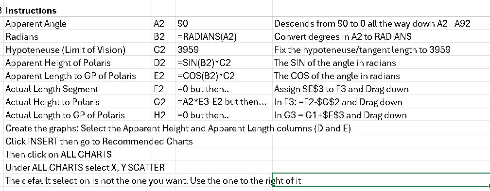
The instructions are at the bottom for anyone who wishes to replicate and test this method.
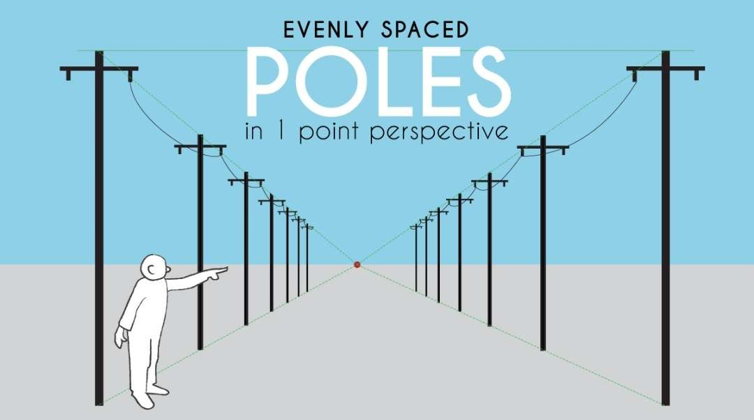
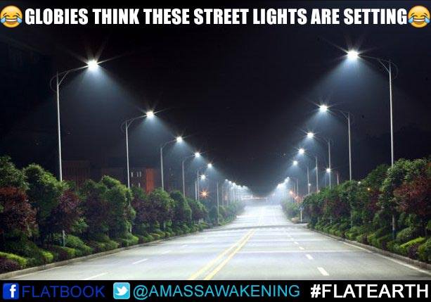
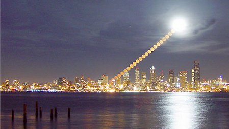
Since globularists noticed the 69 miles per degree relationship and declared that this effect happened solely because of the curve of the earth. Well, for the sky solely because of the curve of the earth, but for mountains, well... that is because of perspective. And for streetlights on a long straight road... well also perspective. And of course tall buildings that compress into the horizon with distance, well that happens because of perspective too. But the stars and the sun the moon are all because of earth curvature I swear!
Essentially, the globular position has to be that this effect happens for everything on earth due to perspective, but it happens to everything in the sky for a completely different reason.

%20-%20Copy%201.jpg)
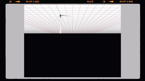
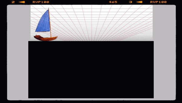
The effect is pictured above. Globers have to accept this happens to street lights, tall buildings, and mountains, all at the same rate, and that the stars demonstrate the same effect, but for a cause that is totally different and unique (curvature/spin).
They had declared this was a linear relationship, and would not be geometrically possible on a flat earth.
---
So, Gleem did this already you say? Please check his work above.
Well, he did indeed create an excellent linear form of this. Ours, is NON linear. Just like you all said we needed.
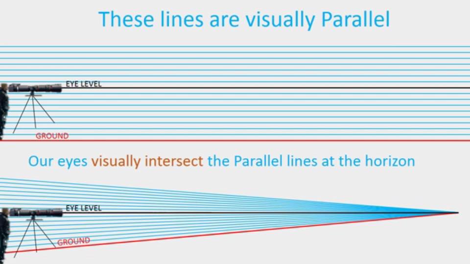
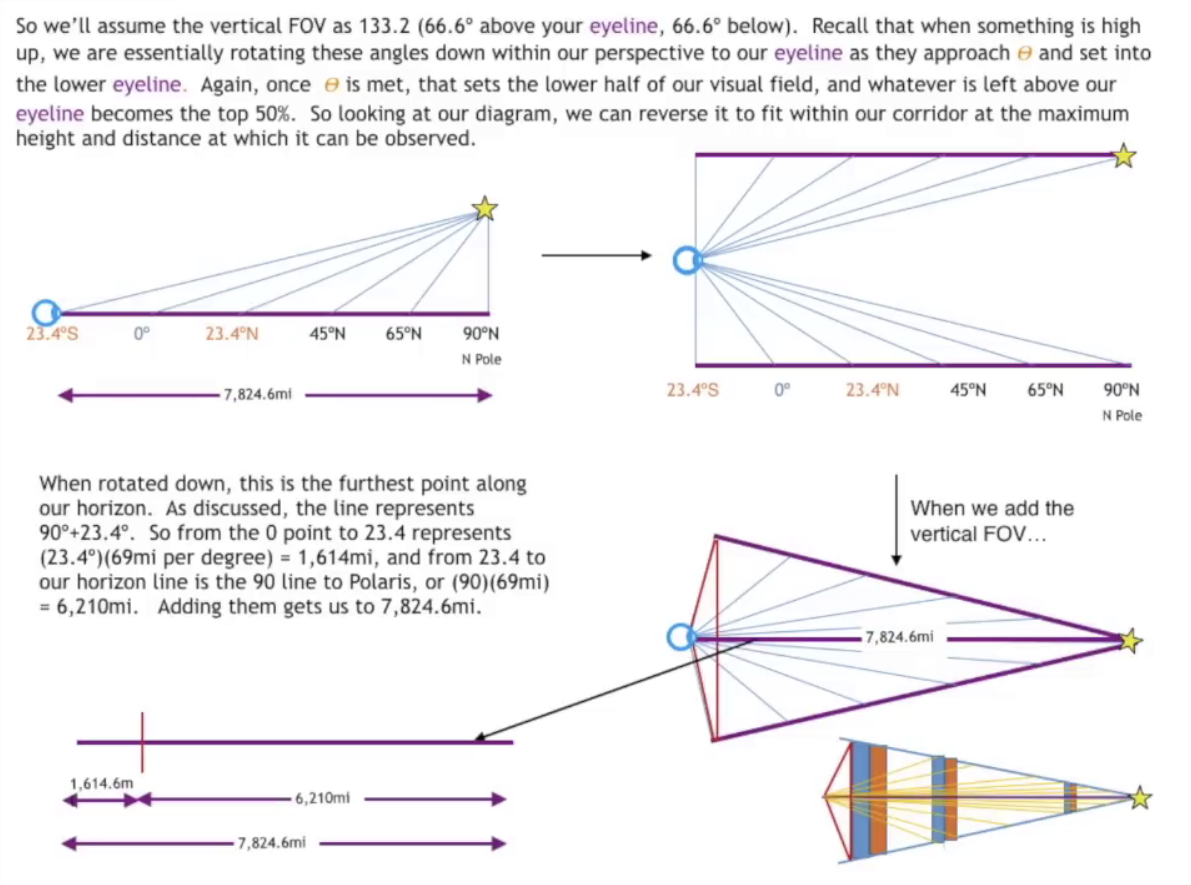
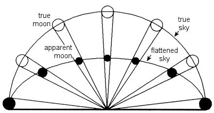
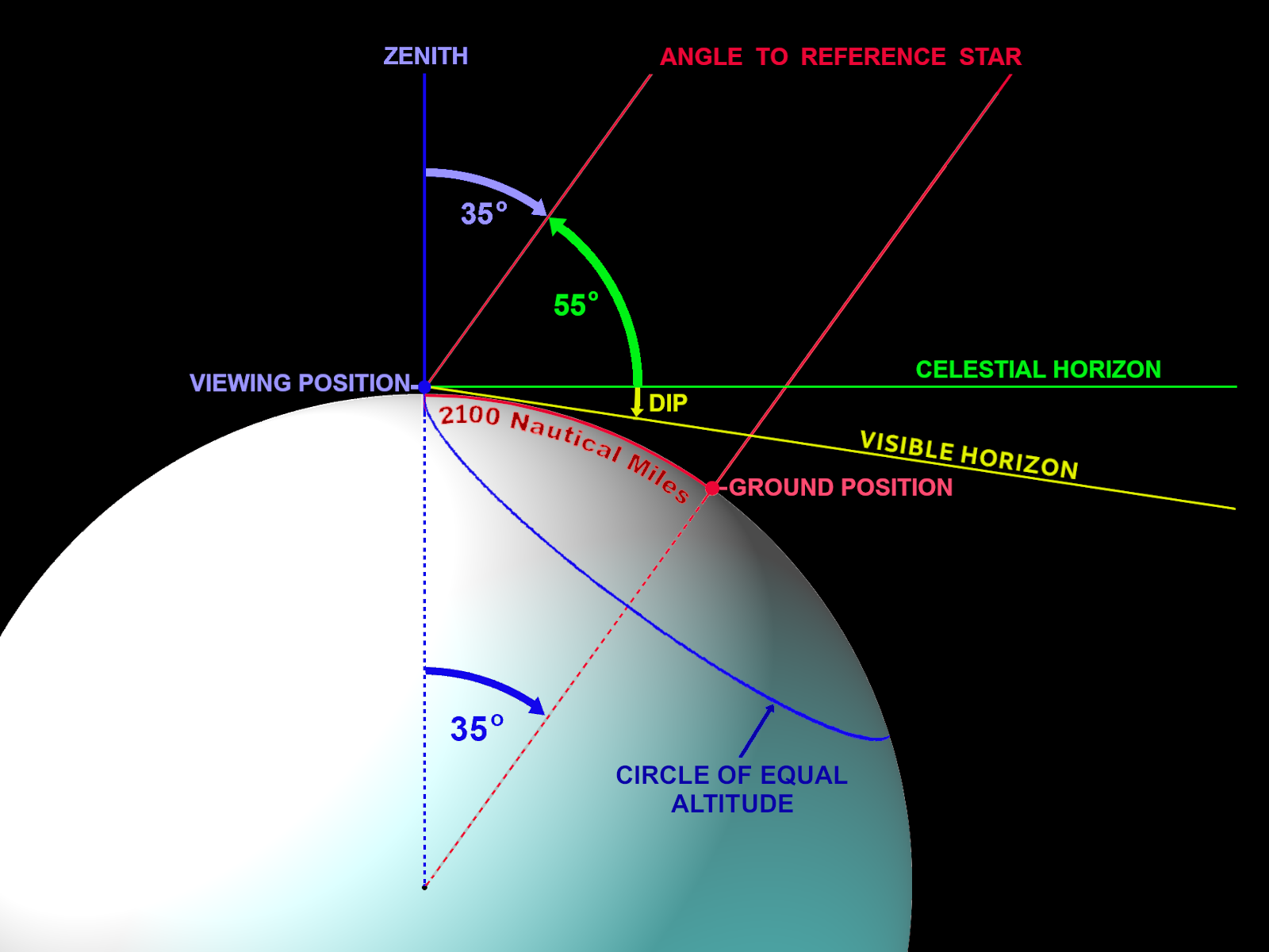
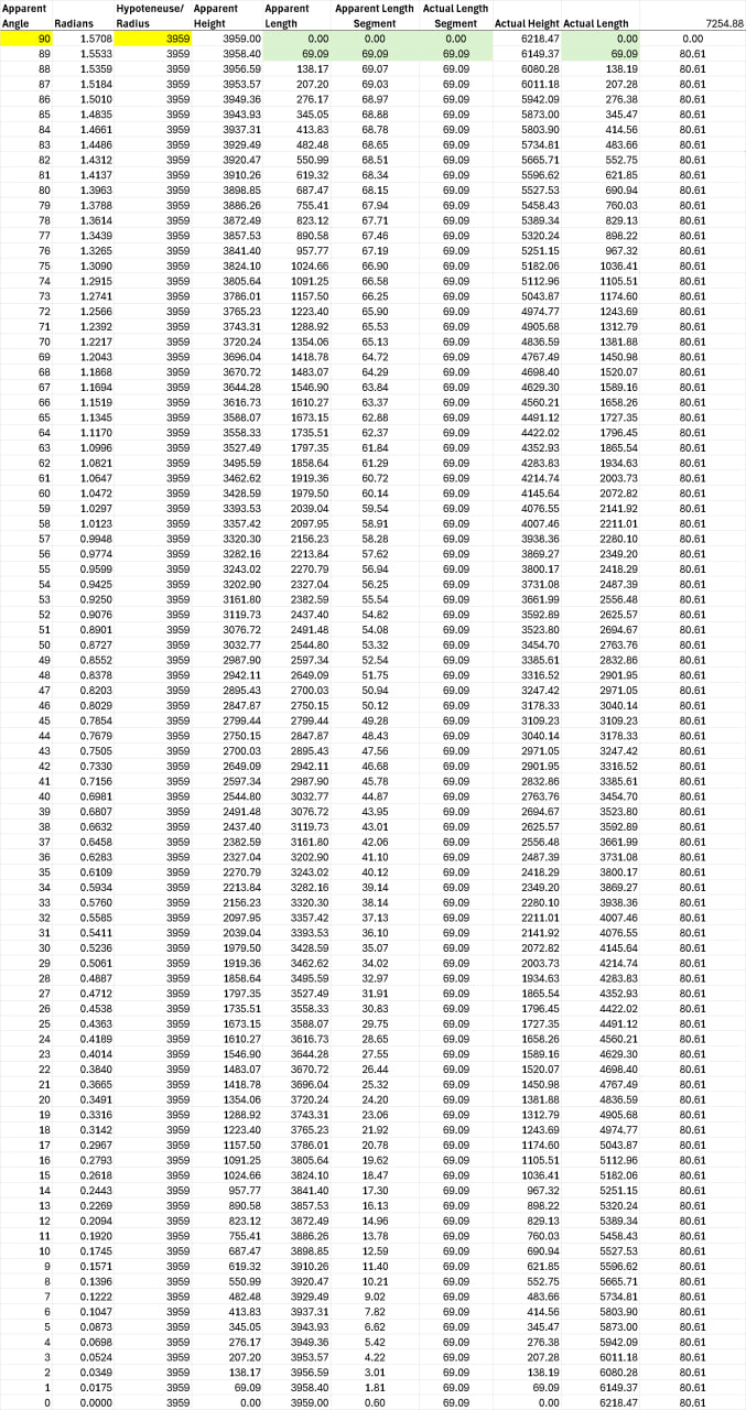
Our spreadsheet outlines our approach to illustrating the kinematic equivalence between observations attributed to a globe Earth and those expected on a flat Earth, particularly concerning the elevation angles to Polaris and the apparent rotation of the night sky. By examining the angles of elevation and the corresponding horizontal and vertical distances, we are delving into the geometric relationships that underpin these observations.
### Steps
Concepts and terminology first:
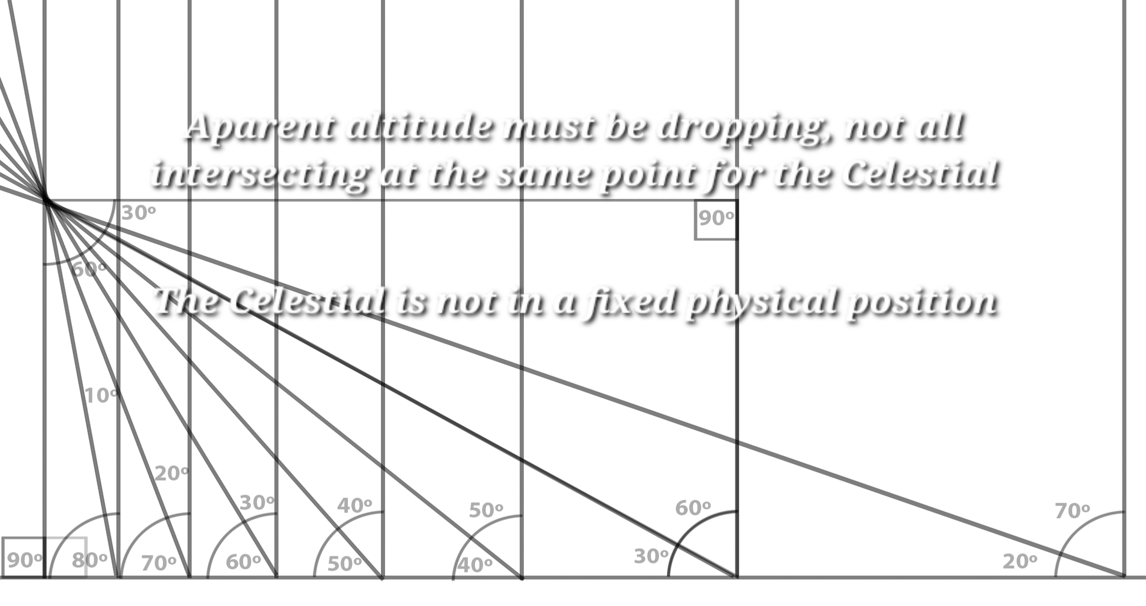
1. **Angle**: The angle of elevation to Polaris, which decreases as one moves away from the North Pole on a globe Earth, or equivalently, as one moves southward on a flat Earth.
2. **Radians**: The angle converted into radians, a necessary conversion for many calculations in trigonometry and physics.
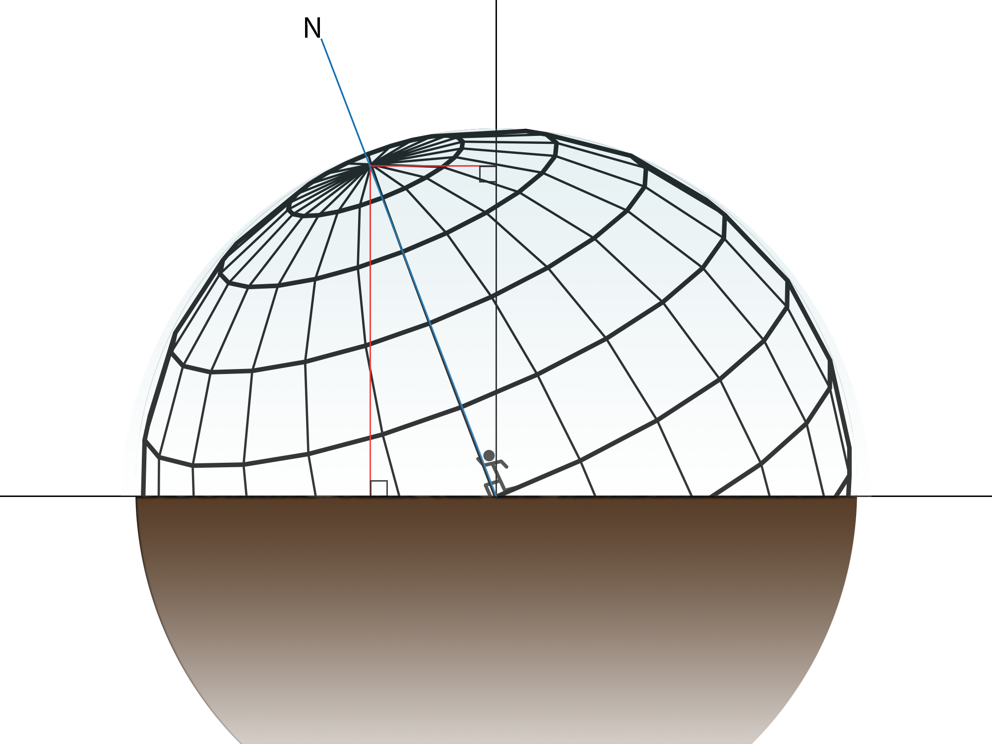
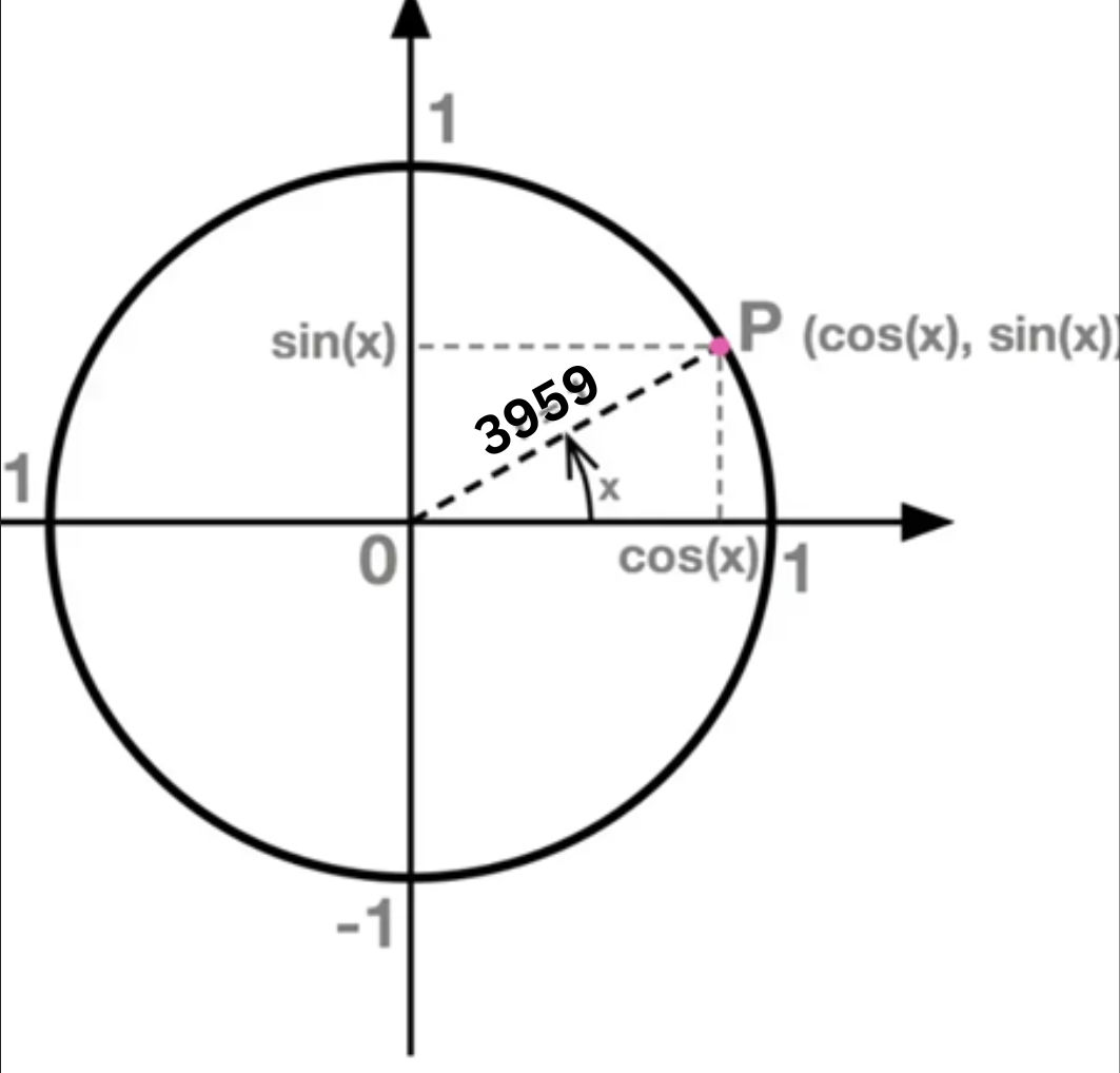
3. **Hypotenuse**: In the context of a globe, this could represent the radius of the Earth. For a flat Earth model, this can be seen as the distance from the observer to the point directly below Polaris along the Earth's surface. In our example, it describes the azimuthal grid of observability radius, 3959.
4. **Height**: This corresponds to the vertical distance from the surface to Polaris. On a flat Earth, many misunderstand this concept and insist this would be constant, but in my table, it changes, which nicely approximates the effect incorrectly attributed to the globe model's curvature. (supposed curvature, remember when they attributed this effect differently to every other object) This value is obtained via a sin function
5. **Length**: GP of Polaris or star: This is the length of the triangle, and the cos of the radians. It represents the distance, apparent or otherwise, to the ground position of the star.
The term "kinematic equivalence" is a way to describe how motion (or apparent motion, in this case) can be interpreted similarly from two different perspectives. My table essentially replaces the globe Earth's curvature by correlating elevation angles to Polaris with specific positions on the Earth's surface, as measured by the "height" (or altitude above the surface) and "length" (or distance from the North Pole or equivalently, the point directly below Polaris). This is a clever way to juxtapose real world observations and predictions with correct flat Earth interpretations.

For our flat Earth model to mimic these observations, I would argue that the apparent decrease in elevation angle to Polaris as one moves "southward" is due to perspective, rather than actual curvature. On a flat Earth, explaining the non uniform change in elevation angles to Polaris over different latitudes (or distances from the North) is a completely valid and even more accurate way to describe the relationship of optics and elevation angles.
Our spreadsheet initiates a foundational comparison of linear and non linear mathematical descriptions of optical angles to celestial bodies.
To address how this model accounts for observations in the southern hemisphere, where Polaris is not visible, and stars rotate around a different point in the sky, we would just invoke the same model we we have always used to describe this, the personal celestial sphere with a latitude dependent axis of rotation. This is an equivalent mechanism on a flat Earth to explain the symmetric observations around the south celestial pole.
[Open: photo_2023-03-24_15-52-58 1 1 1 1.jpg](https://publish.obsidian.md/shanesql/Attachments/photo_2023-03-24_15-52-58+1+1+1+1.jpg)

[Open: photo_2023-05-28_22-03-31 1 1 1 1.jpg](https://publish.obsidian.md/shanesql/Attachments/photo_2023-05-28_22-03-31+1+1+1+1.jpg)
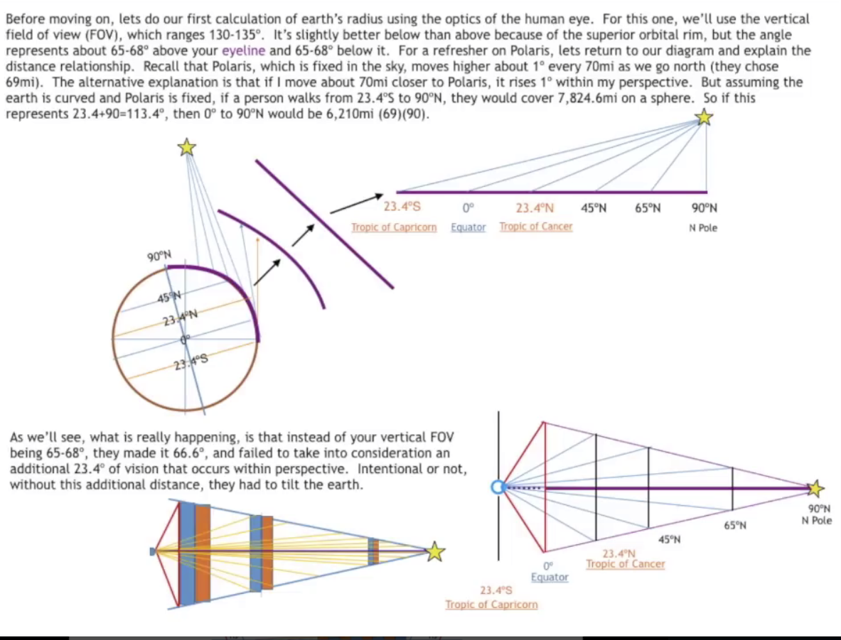
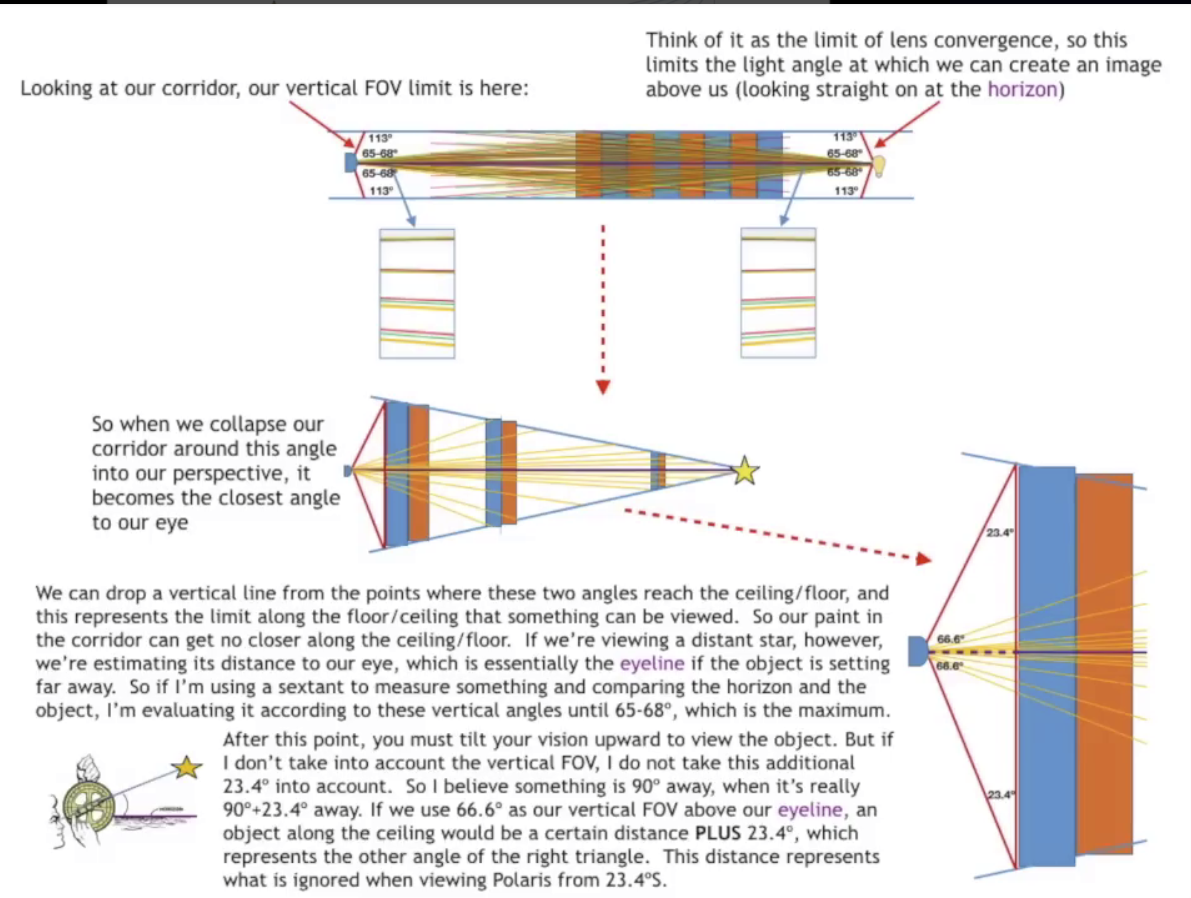
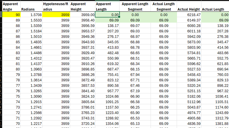
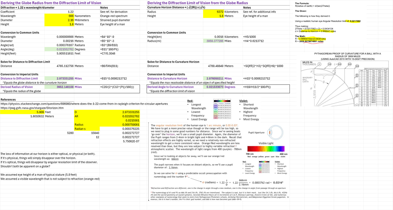
### Radius
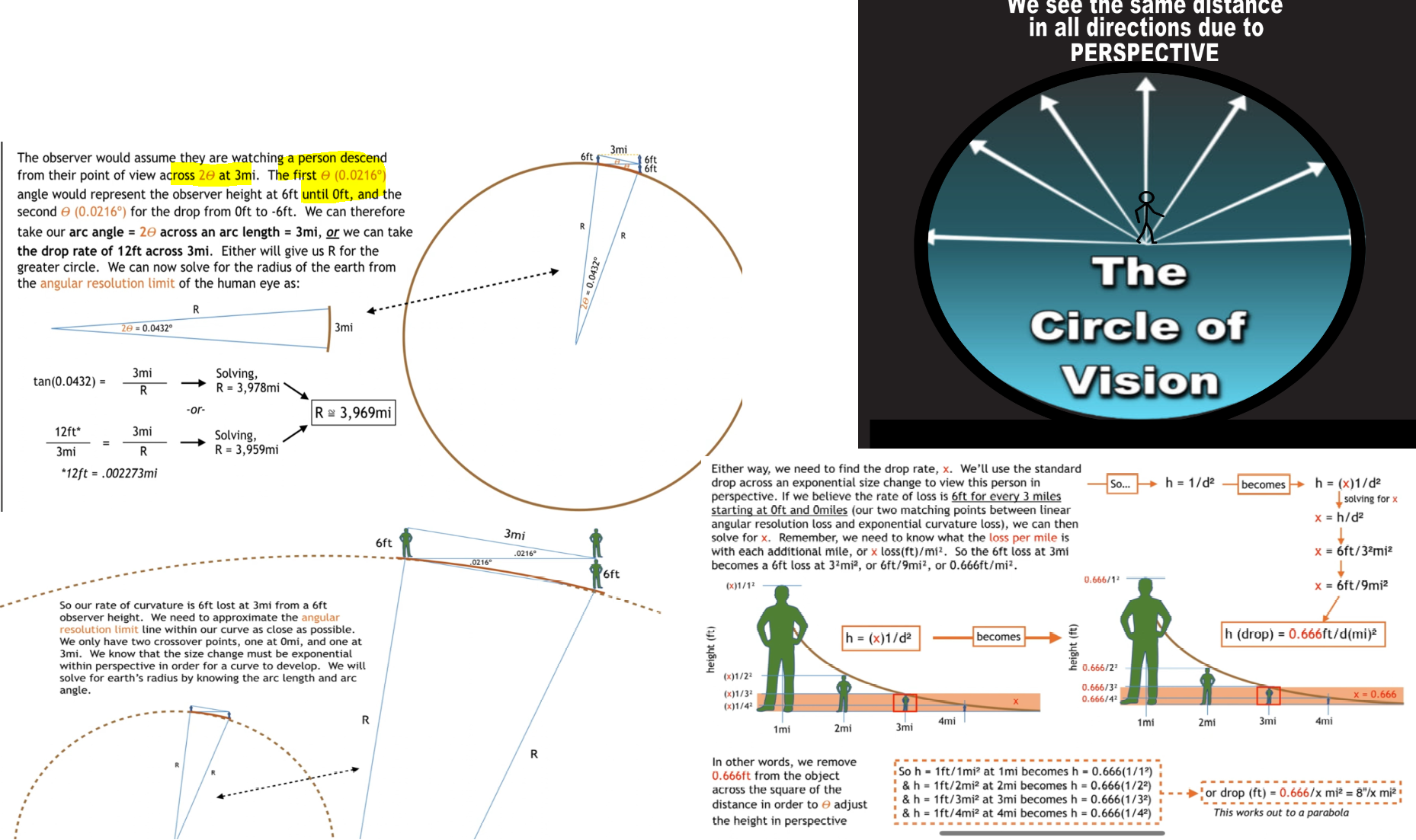
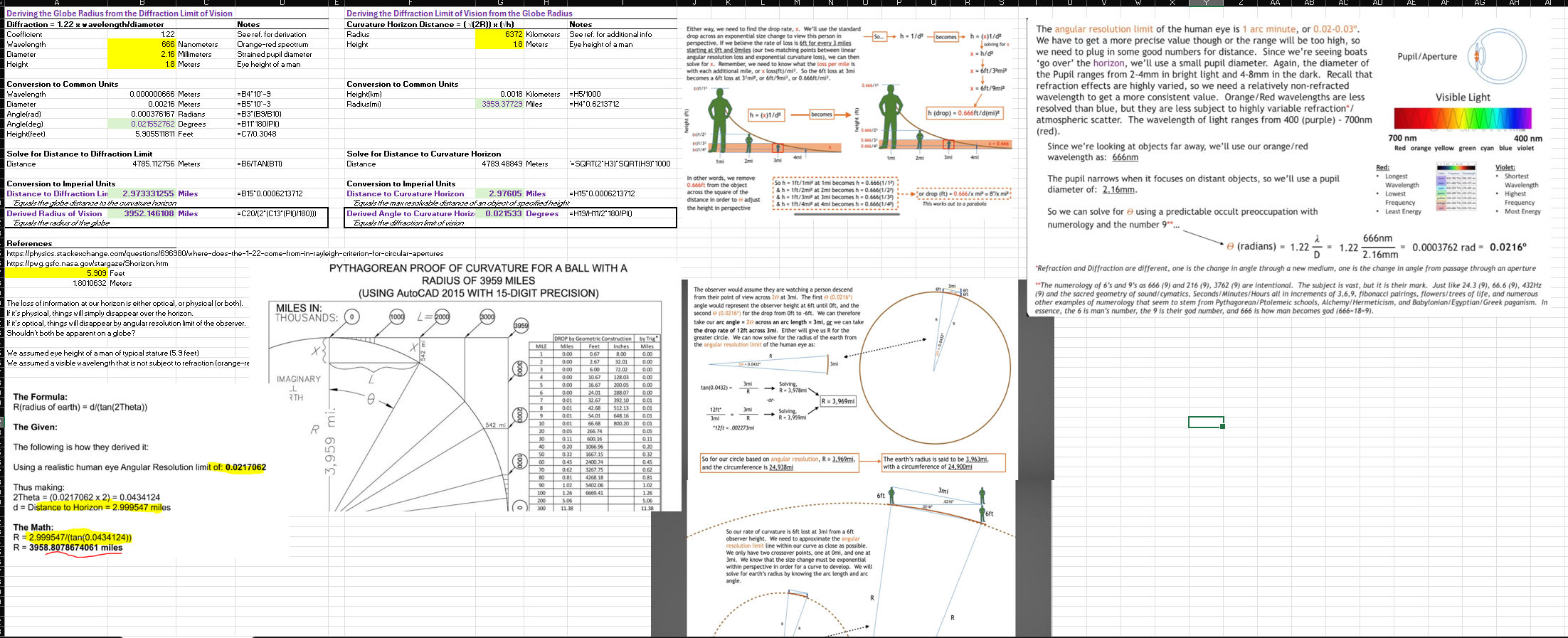
The rate of curvature is 6 feet lost at 3 miles from a 6-foot observer height. The angular resolution limit is approximated closely within the curved perspective. Two crossover points exist at 0 miles and 3 miles, and the size change is exponential within the observer's perspective. The observer views a person descending 6 feet over 3 miles, with angles representing changes in observer height from 6 feet to 0 feet and then to -6 feet. The arc angle is calculated from an arc length of 3 miles or a drop distance of 12 feet over 3 miles to determine the radius of the Earth. Using the angular resolution limit, the radius is calculated to be approximately 3,978 miles. The drop rate for exponential size changes is approximated, resulting in a parabolic height adjustment with increasing distance.
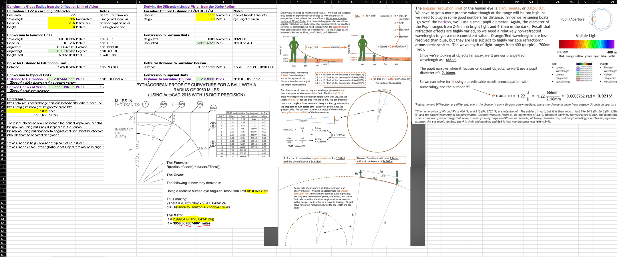
We set the radius to 3959, because we can derive it through optics, see below.
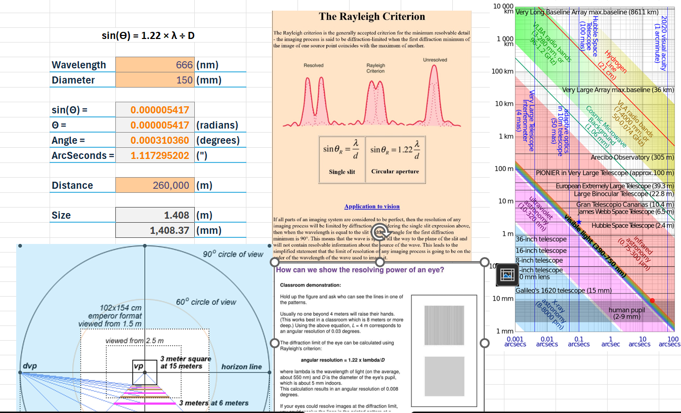
The supporting math based on angular resolution limit and the limit of our vision being spherical
[[Library/Optics Angular Resolution or Earth Curve|Optics Angular Resolution or Earth Curve
[Open: Pasted image 20240509204232.png](https://publish.obsidian.md/shanesql/Attachments/Pasted+image+20240509204232.jpeg)
[Open: Pasted image 20240509103648.png](https://publish.obsidian.md/shanesql/Attachments/Pasted+image+20240509103648.jpeg)
[Open: Pasted image 20240509103648.jpeg](https://publish.obsidian.md/shanesql/Attachments/Pasted+image+20240509103648.jpeg)
[Open: Pasted image 20240509103721.png](https://publish.obsidian.md/shanesql/Attachments/Pasted+image+20240509103721.jpeg)
[Open: Pasted image 20240509103721.jpeg](https://publish.obsidian.md/shanesql/Attachments/Pasted+image+20240509103721.jpeg)
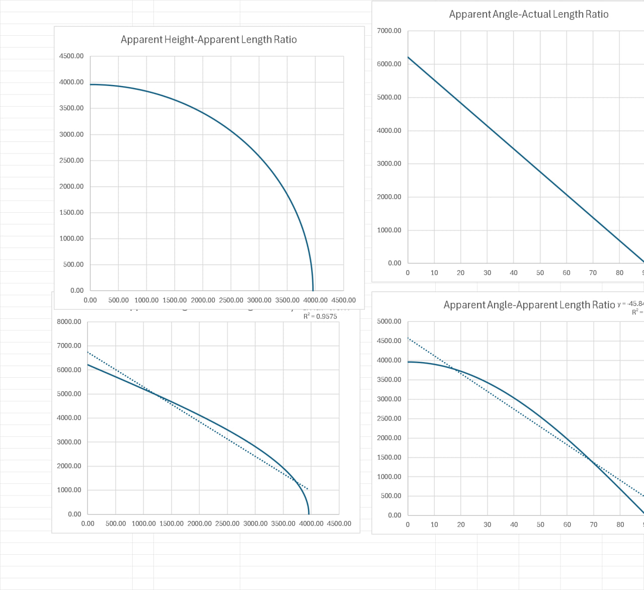
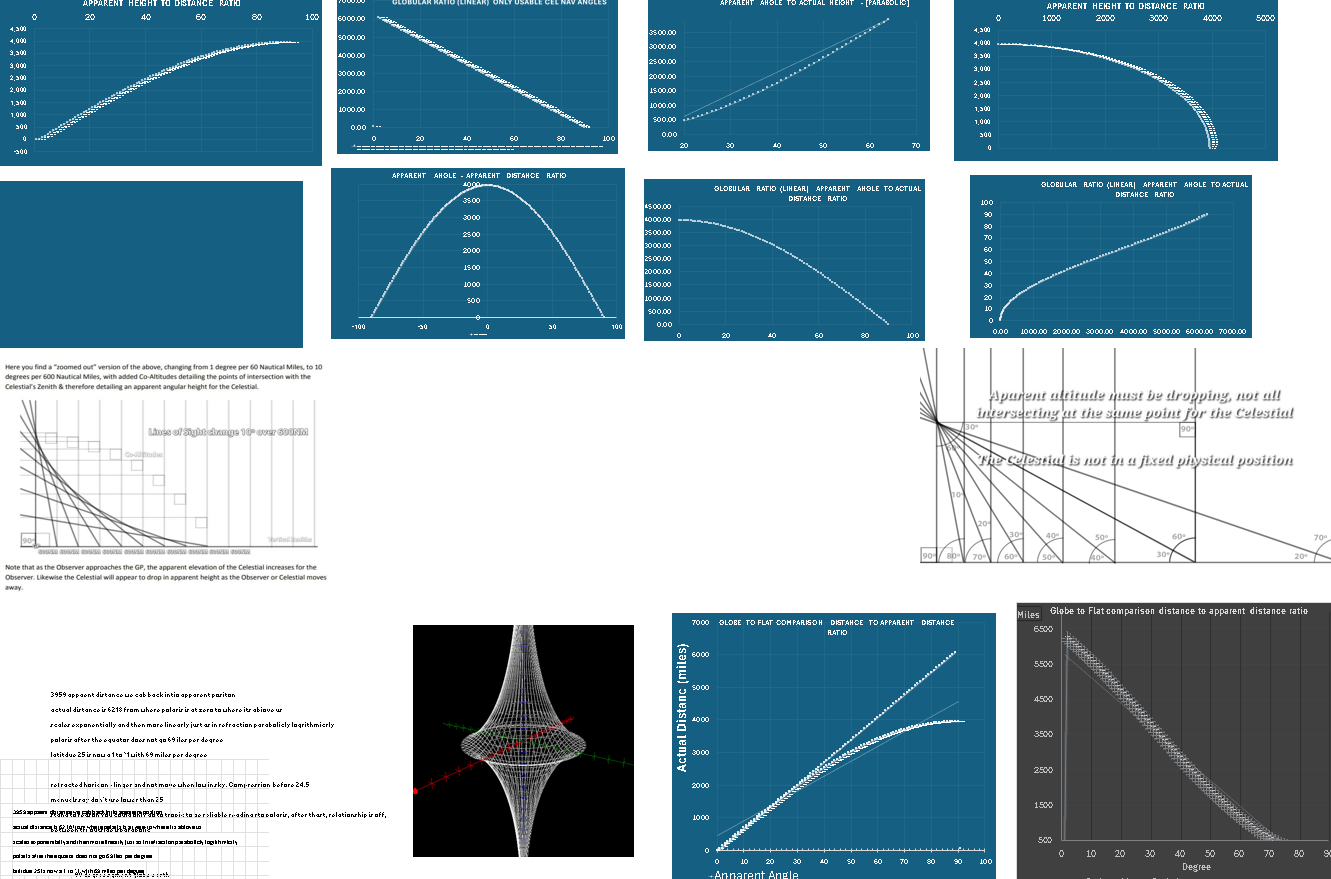
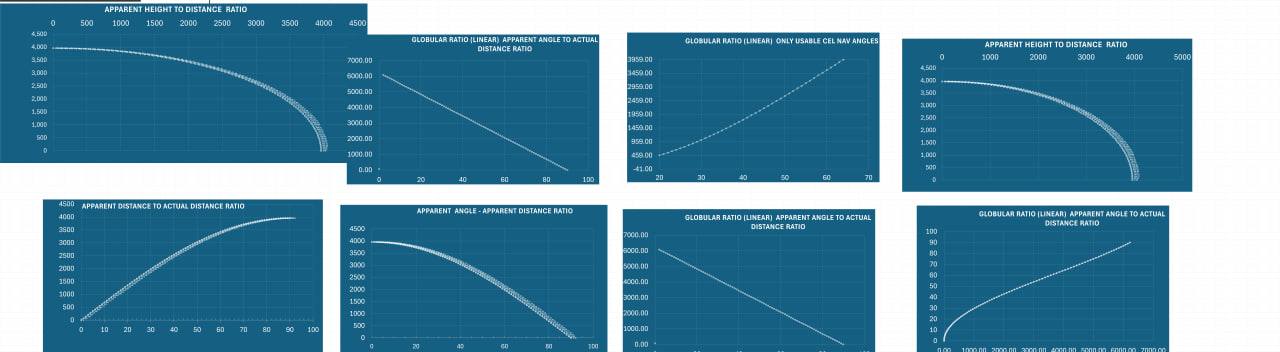
## Non Linear
---
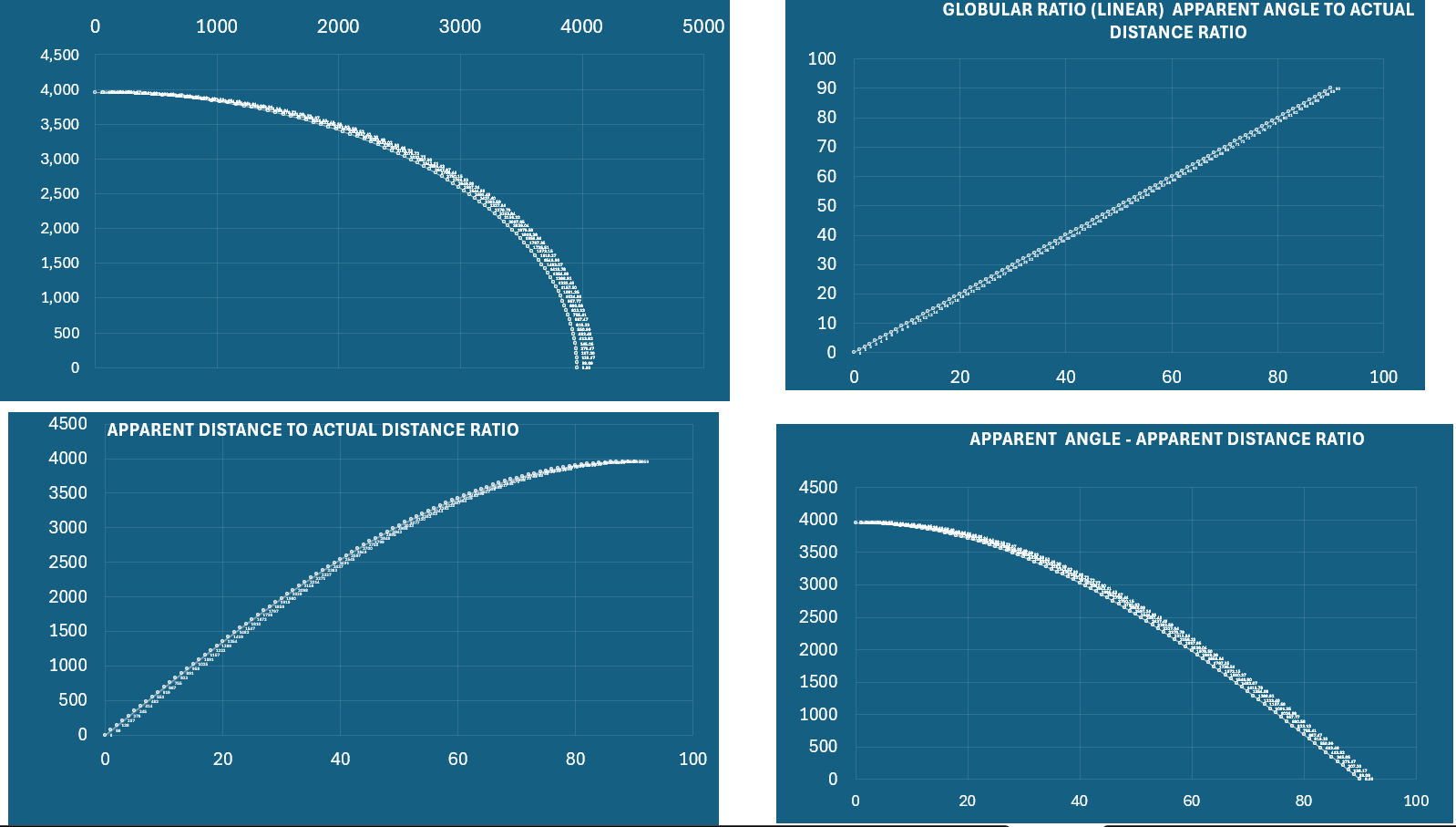
Now, we can describe this exact relationship in a different, **non linear** way. It actually can be parabolic, exponential (logarithmic) or linear, depending on the distance and the portion we are analyzing.
We derived a kinematic equivalence between the proportionate relationship between distance and the amount things in the sky appear to recede on the horizon.
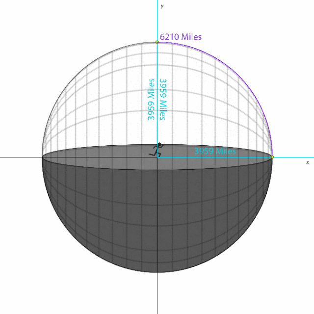
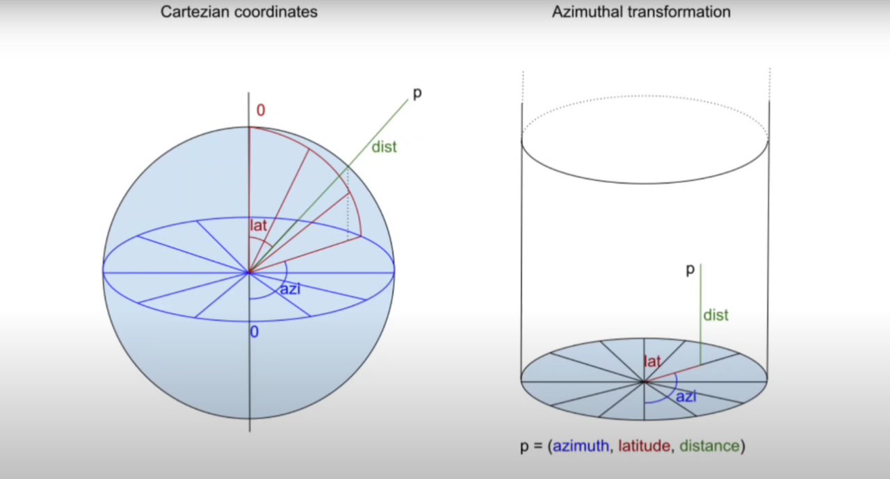
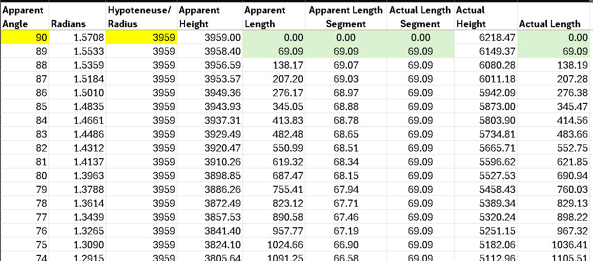
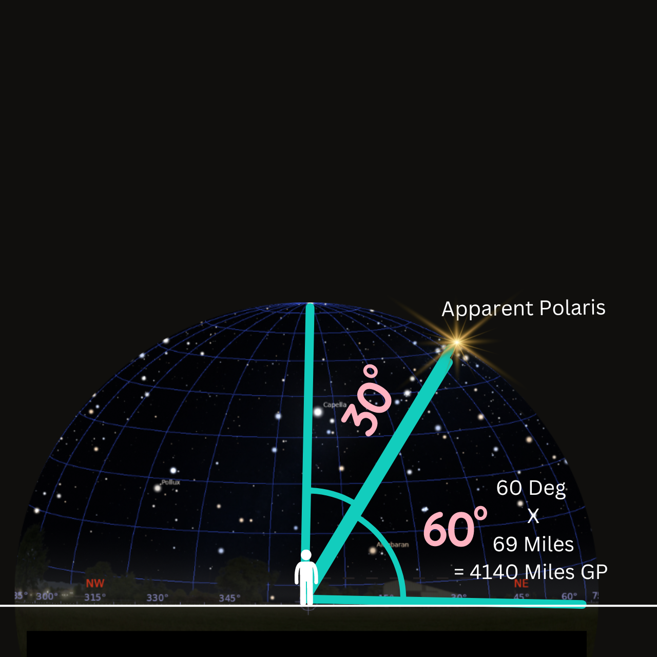
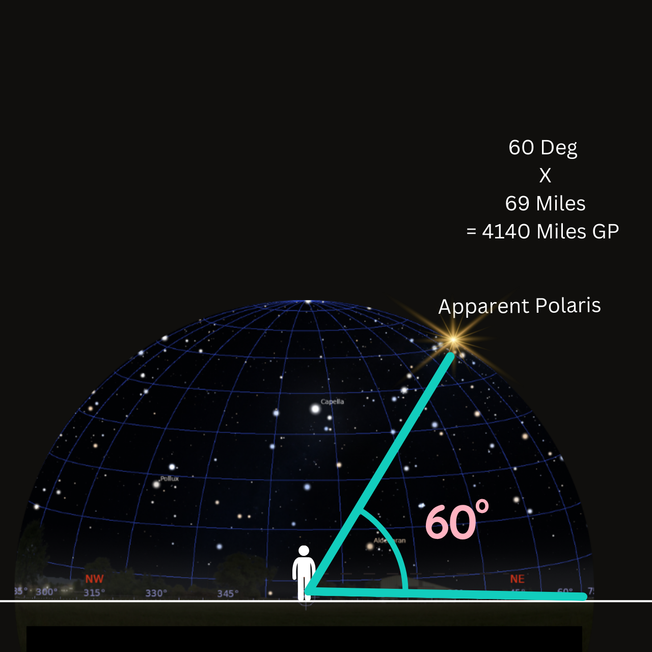
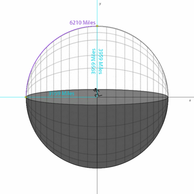
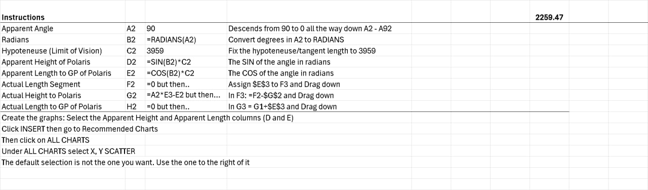
We used a unit circle and basic trigonometry to demonstrate relationship. The height of each created triangle is determined by the SIN of the angle in radians. The length of each created triangle is determined by the COS of the angle in radians. The hypotenuse/tangent length is set to 3959. (the radius of the spherical limits of your vision).
This maintains the proportionate relationship but uses a method that cannot be claimed exclusive to the globe.
## Linear
69 miles per degree.... is not a problem for us, here is why.
%201.gif)
69.07 Statute miles per degree, means that from Polaris to the equator is 69.07 X 90 degrees of latitude = 6210 miles.
This is the LINEAR distance from Polaris to the equator.
For a spherical object, this linear distance would 'shrink' to fit as a curved arc of the same distance. If you straightened out the curved line of 3969, it would be 6210 miles long.
This is how the globers justify this relationship by the way.
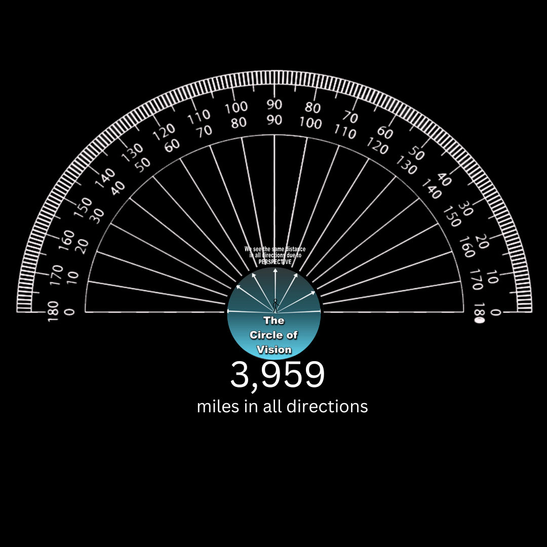
So, if we have a spherical limit to our curved visual space, than it has a radius of 3959, we never have to worry about a linear distance that exceeds that, because of the geometry of a sphere, we would only see 3,959 miles all visible directions.
[Optics Angular Resolution or Earth Curve 1](https://publish.obsidian.md/shanesql/Database+Tabs/Optics+Angular+Resolution+or+Earth+Curve+1)
.jpg)
---
Here are some visuals. Don't mind the canva stick art....
This is supposed to help visualize a linear distance forming a shorter curved arc. Since the shortest distance between two points on a sphere is an arc.... etc.
But, when you hold us to the same standard you have for yourself, considering not using angles below 30 degrees....
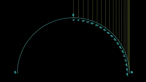
This curve represents the height to the stars and its proportionate change with distance.
This also proves that if you move along this FLAT baseline 69.09 miles, the stars will rotate 1 degree overhead.
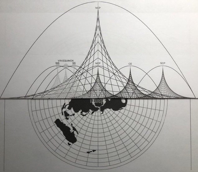
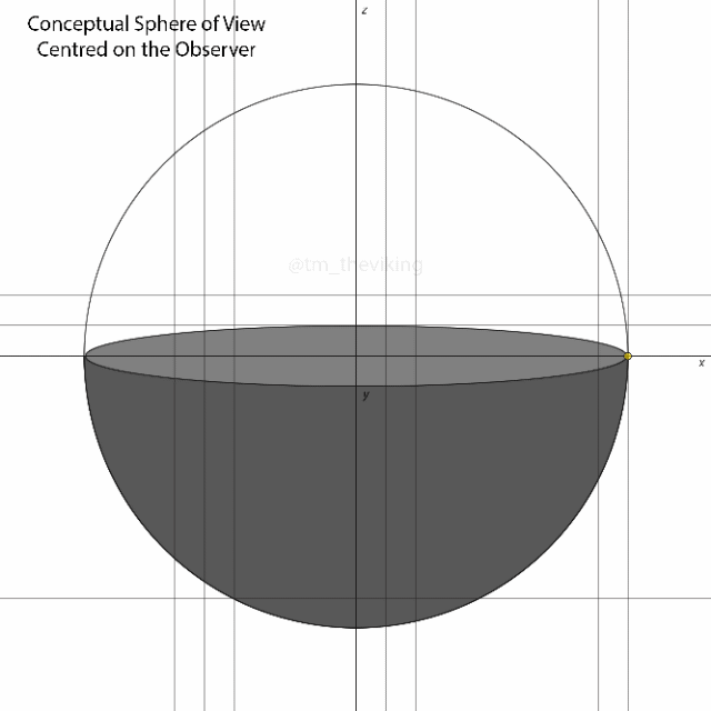
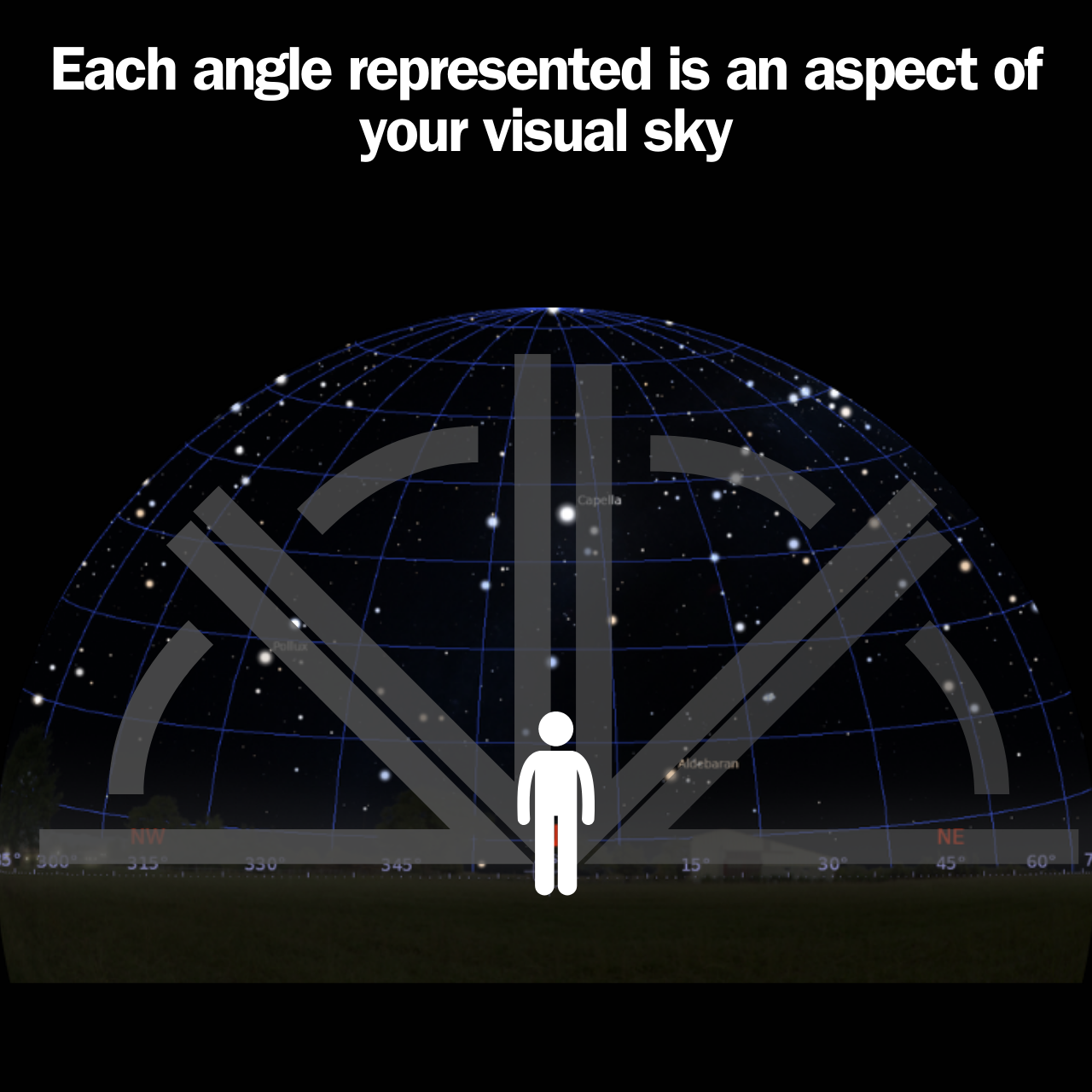
## The personal celestial sphere
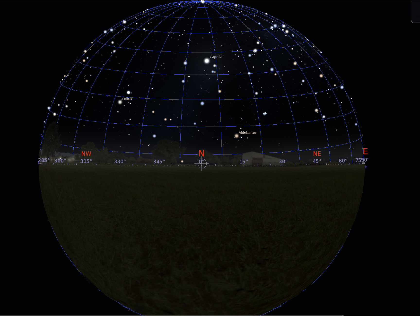
Stellarium in 'Orthographic View'
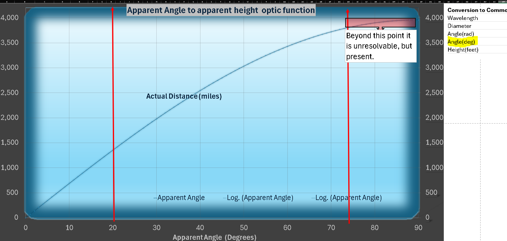
The only graph we will focus on for now: the non linear relationship of apparent angle to apparent height. A function of optics.
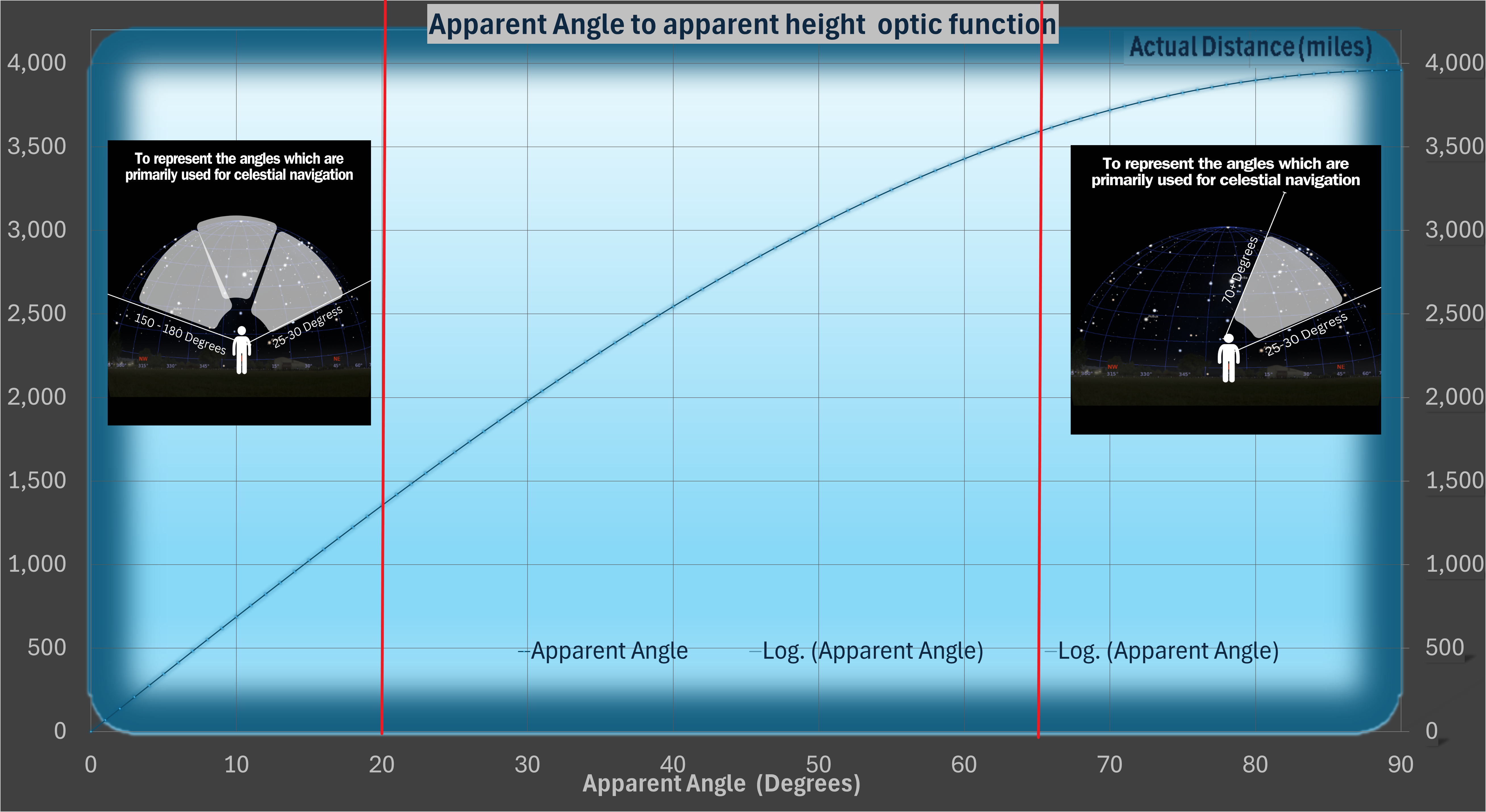
### Is it Linear?


[Open: Pasted image 20240509103703.png](https://publish.obsidian.md/shanesql/Attachments/Pasted+image+20240509103703.jpeg)
[Open: Pasted image 20240509103703.jpeg](https://publish.obsidian.md/shanesql/Attachments/Pasted+image+20240509103703.jpeg)
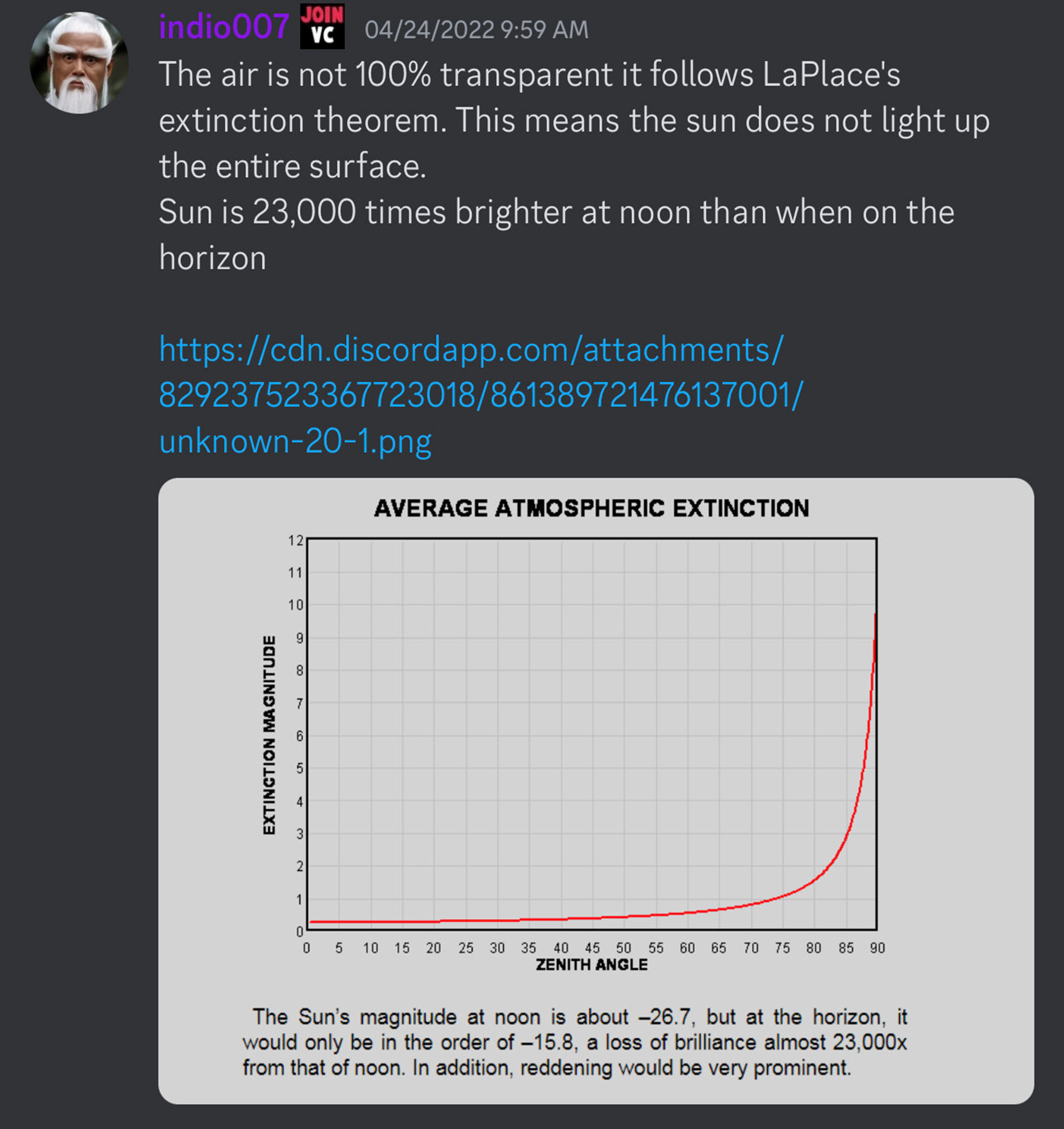
Notice the linear portion is exactly where the tables of corrections for celestial navigation begin. They disavow accuracy below and above this threshold.

This is how they tricked the people. They used what they knew was not a linear expression of optic scaling, and restricted the use of it to the linear portion. In this way, they convinced the mass public that distance scaled linearly through optics. They took this non linear relationship, told you it was linear all the way through, and added correction tables for the non linear portions. Well, if you were using this that way, how would you ever tell it was not in fact, linear?
.png)
The end result of this is we can now justify the personal celestial sphere rising 1 degree per 69.07 of LINEAR distance traveled. They had denied this to us previously, by claiming as a linear function it could not work on flat earth. Although we disagree, we have derived a different way to use the relationship. This also more accurately describes what happens at the extremes of your vision. At each horizon, for example, the relationship of polaris's elevation angle is not linear. It will not ACT linear until, surprise surprise, 20 degrees on the horizon. Only then will you observe that relationship linearly. If something on the horizon is not visible a non linear function could describe it as approaching the maximum of your vision, but not quite reaching it. It would approach it without reaching it forever, trapped in the logarithmic portion of that function. This would actually perfectly describe an object that is just about outside the range of your angular resolution. If it is just about to become unresolvable, the logarithmic portion describes that reality perfectly.
[Open: wwed 1 1 1 1.png](https://publish.obsidian.md/shanesql/wwed+1+1+1+1.jpeg)
### The process
[Open: Pasted image 20240229134048 1 1 1.png](https://publish.obsidian.md/shanesql/Attachments/Pasted+image+20240229134048+1+1+1.jpeg)
[Open: Pasted image 20240229134107 1 1 1.png](https://publish.obsidian.md/shanesql/Attachments/Pasted+image+20240229134107+1+1+1.jpeg)
But what about the sun and the moon? Well they act a little differently. Its safe to say the above method applies to any static star of equal distance away, or any star in the personal celestial sphere.
## Apparent VS Actual
But why are you using apparent height? What is actual height? What is the difference?
Short answer:
Because apparent is all we ever see, it is all we ever use to measure, why would i be concerned with anything else?
This was taken from NASA before they took it down.
[https://web.archive.org/web/20220128205422/https://www.nasa.gov/vision/universe/watchtheskies/20jun_moonillusion.html](https://web.archive.org/web/20220128205422/https://www.nasa.gov/vision/universe/watchtheskies/20jun_moonillusion.html)
[https://www.ks.uiuc.edu/Research/vmd/current/ug/node99.html](https://www.ks.uiuc.edu/Research/vmd/current/ug/node99.html)
And putting it all together we get....
## Personal Celestial Sphere
.png)
.png)
.png)
.png)
.png)
.png)
Simply mimics the already in place and observed Celestial Sphere.
The 'mechanism' that is at work is simply any movement processes the celestial sphere 1 degree per 69 statue miles. Previously, this was a claimed effect of curvature. Now we have proven if you process 69 statue miles laterraly on a flat plane your personal celestial sphere processes the same 1 degree over you. There is no real difference.
.gif)
.png)
Putting it all together


.jpg)
.gif)
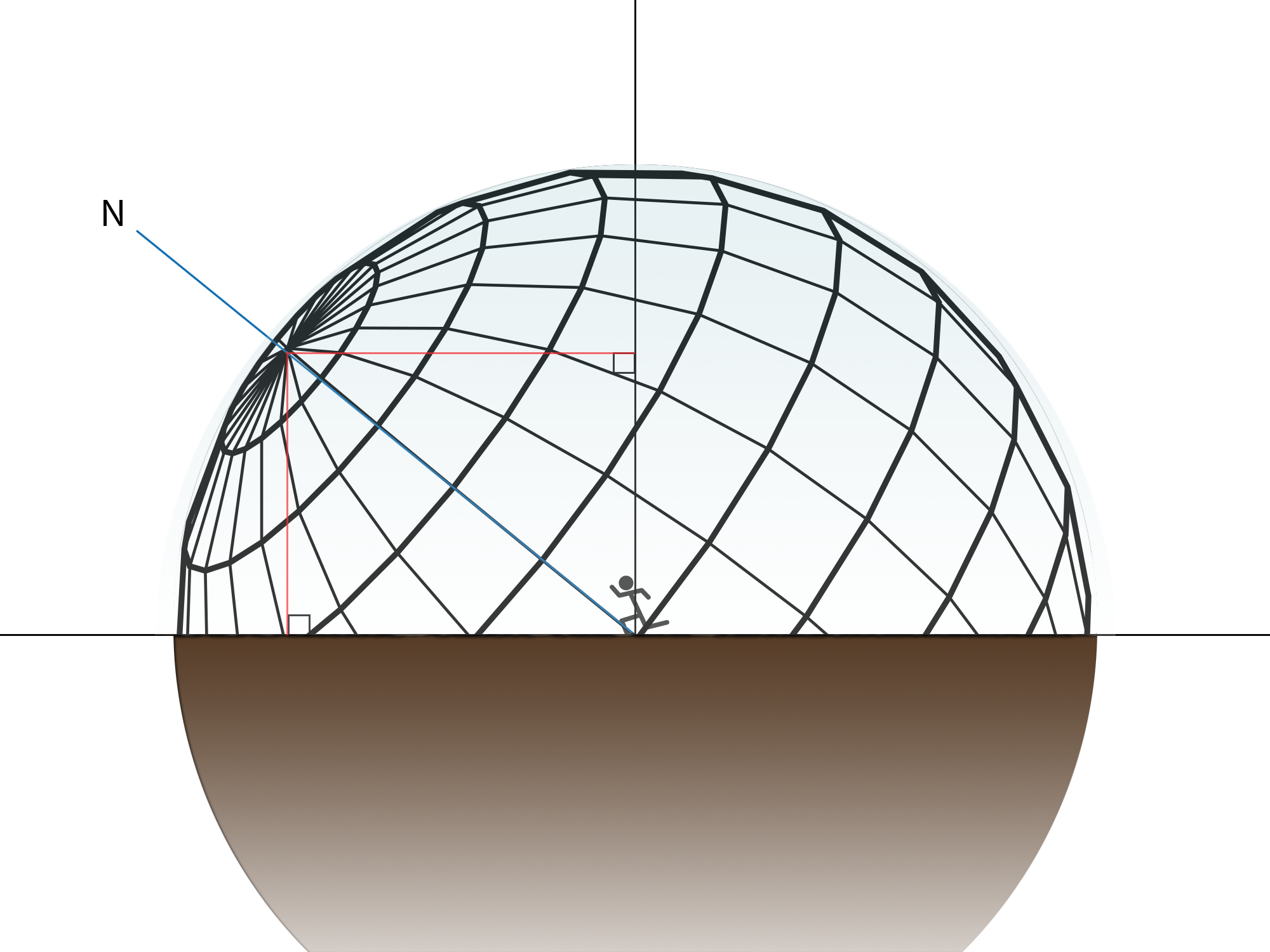
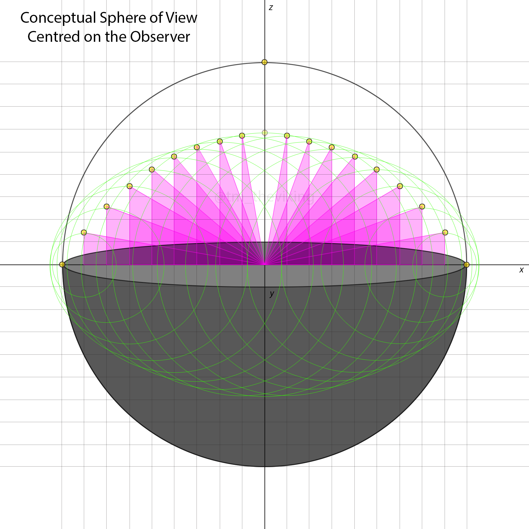
Celestial sphere projected around the observer, extending 3,959 in every direction and follows the observer on the flat plane.
Linear or Geodesic Arc? 6218 or 3959?
%201.png)
%201.png)
.png)
.png)
%201.png)
.png)
In conclusion, it has now been proven that this phenomena is REAL and happens on earth (flat or globe) EVERYWHERE, ALL THE TIME.
We knew this already of course, but now we have the the math that proves it. Therefor, that relationship can no longer only be linear, and is now no longer exclusive to globularity.
Finally, this forms the basis of the azimuthal grid of observability concept. It surrounds the observer in a 'circle' that moves and rotates with the observer. We set that radius to 3959 to match reality, and this follows the observer around the flat earth exactly as we explained and modeled before.

And we have been using the same celestial sphere over flat earth ever since.
That looks familiar. It looks like they just kept using that model forever; Office, G. B. N. A. and U. S. N. O. N. A. Office (1961). Explanatory Supplement to the Astronomical Ephemeris and the American Ephemeris and Nautical Almanac, H.M. Stationery Office.
Celestial navigation works because... we are where you pretend to be. Simple as that.
Don't forget those corrections....
## Correction s
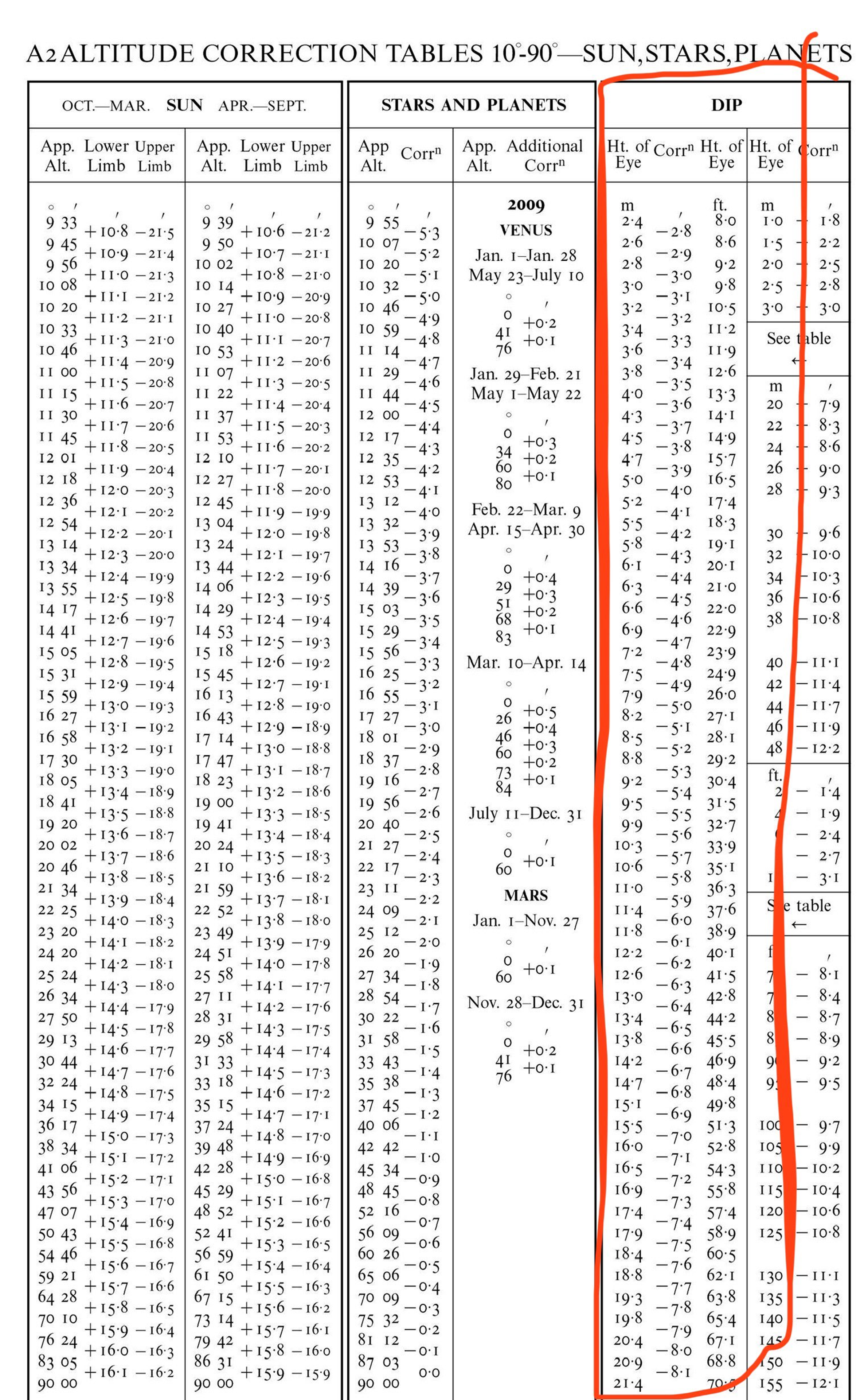
Basic Cel nav using celestial sphere
[https://www.marinenavigationbooks.com/images/pdfs/Chapter-01-Concepts-of-Celestial-Navigation.pdf](https://www.marinenavigationbooks.com/images/pdfs/Chapter-01-Concepts-of-Celestial-Navigation.pdf)
[Open: Pasted image 20240229134048 1 1 1.png](https://publish.obsidian.md/shanesql/Attachments/Pasted+image+20240229134048+1+1+1.jpeg)


Coordinate system transforms are important...
The math behind it:
A lot like this in reality:
Well if we apply the same corrections that they apply to their linear celestial navigation angles....
---
*All globularist objections can be formalized, composed and sent to the circular filing cabinet in the corner of your room. Thanks
---
### CREDIT*
Our Amish Friend
Gleem - the coolest person on discord
With lots of help from:
[https://www.patreon.com/TM_TheViking](https://www.patreon.com/TM_TheViking "https://www.patreon.com/TM_TheViking")
The viking's complete breakdown:
And of course, special thanks to:
### Walter Bislin
The wonderful anti-flat earther who provided the backbone for what would become our FE model. Let me just explain why this we find this funny, and rightfully so. I am not saying Walter Bislin is stupid, not at all. He is very intelligent. However, his POSITION renders his argument stupid. Let me clarify: as a globe believer, he HAS to adopt the '69 miles per degree' relationship is exclusive to the globe, otherwise the whole argument basis is moot. We have always claimed this and they have never conceded it because if they do, the sky is ours. His only objection is this:
"How does the Azimuthal Grid of Vision know its latitude, Witsit". This statement alone illustrates the logical constraints Walter has to operate under. He cannot admit that everyone on earth has always known their latitude equals the elevation angle of Polaris. Its how they navigated the seas without longitude for more than a thousand years. Look into it.
Anyway,
Thanks Walter!
Why can’t we see Polaris from everywhere on the flat earth?
[https://youtu.be/V_RceH0-hSk](https://youtu.be/V_RceH0-hSk)
The below is speculation for a future application of optics as a dynamic scaling distance using a vieth-mueller torus and hyperbolic, parabolic and logarithmic distance scaling.
%201%201%202.png)
%201%201%201%201%201%201%201%202.png)
![[Attachments/1 (6).png]
%201%201%201.png)
%201%201%201%201%201%201.png)
%201%201%201.png)
%201%201%201%201%201%201%201%201%202.png)
### Glober Objections:
%201%201%201%201%203%201%201%201%201%202.png)